
Updated Guidelines Provide Roadmap for Reliable Land Cover Maps
Systematic overview of good practice methods helps researchers and practitioners ensure map accuracy.
Early in her work leading global land cover mapping projects, Associate Research Professor Alexandra (Sasha) Tyukavina understood just how much depended on the reliability of the maps themselves. “A map that is lacking an accuracy assessment is just a prototype or an untested hypothesis and should not be used as a source of information,” she said, quoting the executive summary of the newly released Land Cover Map Validation Guidelines.
The guidelines, produced by the Working Group on Calibration & Validation’s (WGCV) Land Product Validation (LPV) subgroup within the Committee on Earth Observation Satellites (CEOS), outline best practices for validating map accuracy. Tyukavina is a current co-lead of CEO’s Land Cover focus area with Nandika Tsendbazar from Wageningen University (Netherlands) and Sophie Bontemps from Université catholique de Louvain (Belgium).
The updated guidelines are the result of a three-year effort led by Tyukavina, with contributions from GEOG colleagues Anna Komarova, Xiaopeng Song, Amy Pickens, Peter Potapov and Matt Hansen. They provide a comprehensive reference for graduate students, researchers and practitioners, offering clear best practices for validating global land cover maps. The guidelines are freely available online.
The original 2006 guidelines were created in a very different era, before the Landsat archive became freely accessible in 2008. Back then, map validation was costly because of the limited access to higher resolution satellite data, so many maps were assessed with whatever reference points were on hand. Today, global open remote sensing data archives, such as from Landsat and Sentinel-2 missions, enable globally representative map validation at a reduced cost compared to early 2000s. At the same time, deriving high quality reference land cover class labels could still be costly, requiring thorough training of the interpreters, multiple quality checks, and in many cases acquiring commercial high-resolution or field data to supplement freely available satellite data.
“We are trying to emphasize the idea that map validation should not be done as an afterthought when the map is already created, but planned ahead, with significant resources allocated towards validation” says Tyukavina, citing the recommendation from the original guidelines to allocate a third of a project budget towards validation.
Another difference compared to the era of the previous guidelines is that platforms like Google Earth Engine make it possible to produce maps of the entire planet in hours but that accessibility also increases the risk of low-quality products. “The result is an increasing informational noise and having robust accuracy assessment for all map products released to users is becoming increasingly important,” Tyukavina said.
The updated guidelines introduce several key innovations. They emphasize estimating land cover class areas alongside traditional accuracy assessment, accounting for errors in reference data and incorporating novel reference data sources such as spaceborne, airborne and drone-based lidar data, and high-resolution satellite and drone-based optical imagery. Emerging topics including operational validation updates, near real-time map accuracy assessment and local map quality metrics are also covered.
Beyond methods, the guidelines are user-friendly, including an interactive table of contents, internal links to sections, figures and tables and clear references to methodological studies from the past two decades. This structure allows both newcomers and experienced researchers to easily find guidance and apply best practices to their own projects.
“The guidelines will be useful to map users because they can read the description of the validation methodology and reported accuracy results for the map they are using, and compare them to what is considered ‘good practice’ in the guidelines, thus verifying that the map producer or an independent entity performing map validation did due diligence in assessing the quality of the map,” she explained.
“This is an incredibly important work, and I am glad that colleagues from our Department are leading it and are heavily involved,” said Associate Professor Sergii Skakun, who is also the associate chair. “The correct statistical inference from the map, e.g., regarding land cover and land use change areas, is a fundamental problem. And these updated practices show the community how these should be properly done, so maps will not be misused.”
The publication continues GEOG’s leadership in setting global standards for Earth Observation data products, following previous protocols such as the Aboveground Biomass guidelines led by Associate Professor Laura Duncanson and setting the stage for ongoing updates including burned area validation led by Research Professor Louis Giglio.
“I also want to point out that this is a women-led project, with five out of seven editors identifying as female, and many chapter leads and co-authors as well, whereas the original 2006 guidelines were exclusively male-authored,” Tyukavina said, calling it evidence of positive gender dynamics in the field of quantitative remote sensing. “We were intentional about reaching out to authors and reviewers with diverse backgrounds, to make this new document truly a community standard of practice”.
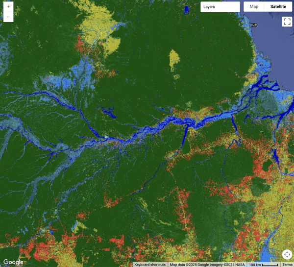
Main image: Zoomed-in view of the Amazon River from UMD-GLAD's Global Land Cover and Land Use Change (2000–2020). P.V. Potapov, M.C. Hansen, A.H. Pickens, A. Hernandez-Serna, A. Tyukavina, S. Turubanova, V. Zalles, X. Li, A. Khan, F. Stolle, N. Harris, X.-P. Song, A. Baggett, I. Kommareddy, A. Komareddy (2022).
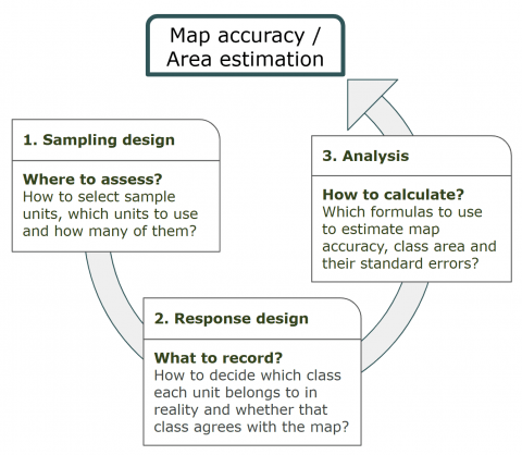
Figure "Map Accuracy/Area Estimation" courtesy of Alexandra (Sasha) Tyukavina
Related Article
How Validating Forest Maps Led to a Better Way to Quantify Global Land Change
Published on Tue, 09/23/2025 - 14:12