
How Validating Forest Maps Led to a Better Way to Quantify Global Land Change
GLAD researchers publish a unified set of methods for validating land cover and change data at any scale.
Thirteen years ago, Associate Research Professor Alexandra (Sasha)Tyukavina at GEOG’s Global Land Analysis and Discovery (GLAD) Laboratory began working to validate global forest loss maps. Now, she and her colleagues have distilled over a decade of insights into a new publication in Remote Sensing of Environment that offers a comprehensive framework for verifying global land cover and change data.
The paper, “Practical global sampling methods for estimating area and map accuracy of land cover and change” provides guidance for turning classification model outputs into reliable estimates of what’s actually happening on the ground.
Developed in collaboration with Professor Stephen Stehman of the State University of New York's College of Environmental Science & Forestry, the framework supports both equal- and unequal-probability sampling across populations of uniform or varying unit sizes.
“This is especially valuable when working with global datasets stored in geographic coordinates (latitude/longitude), where pixel areas are unequal—a common challenge in our field,” said Tyukavina, lead author of the study.
In addition to the theoretical foundation, the paper includes Python code to help researchers implement the methods. The goal is to make statistically rigorous area estimation and map validation more accessible, reproducible, and tailored to specific project needs.
“In the past we had to refer to multiple publications containing special-case equations and use different versions of the code, which often led to confusion as to which equations to use in which case,” explained Tyukavina. “I hope that this overview of commonly used one-stage sampling designs accompanied by a unified set of equations and a code repository helps reduce this confusion."
Tyukavina is also leading work on updating the global land cover map validation guidelines, which are currently in review and are expected to be published later this year through the Committee on Earth Observation Satellites (CEOS) Land Product Validation (LPV) working group. This 150-page guidelines document, co-authored by 34 scientists from nine countries, will provide a broader overview of the accuracy assessment methods.
“The paper that we just published will be useful for the guidelines document as a one-stop reference for estimation equations,” Tyukavina said. “But unlike the guidelines, it focuses only on the sampling implementation and estimation aspects of map accuracy assessment, and doesn’t address other topics like response design and sources of reference data, which are discussed in the guidelines.”
Tyukavina also noted that the new paper is highly technical and should not be used as an introductory reading for researchers not familiar with the topic of map accuracy assessment. She recommends starting with the following publications instead: Stehman and Czaplewski (1998), Olofsson et al. (2014) and Stehman and Foody (2019).
“Practical Global Sampling Methods for Estimating Area and Map Accuracy of Land Cover and Change.” Alexandra Tyukavina, Stephen V. Stehman, Amy H. Pickens, Peter Potapov, Matthew C. Hansen. Remote Sensing of Environment, Volume 324, 2025, 114714, ISSN 0034-4257, https://doi.org/10.1016/j.rse.2025.114714
Main image: Map data © OpenStreetMap contributors, CC-BY-SA 2.0
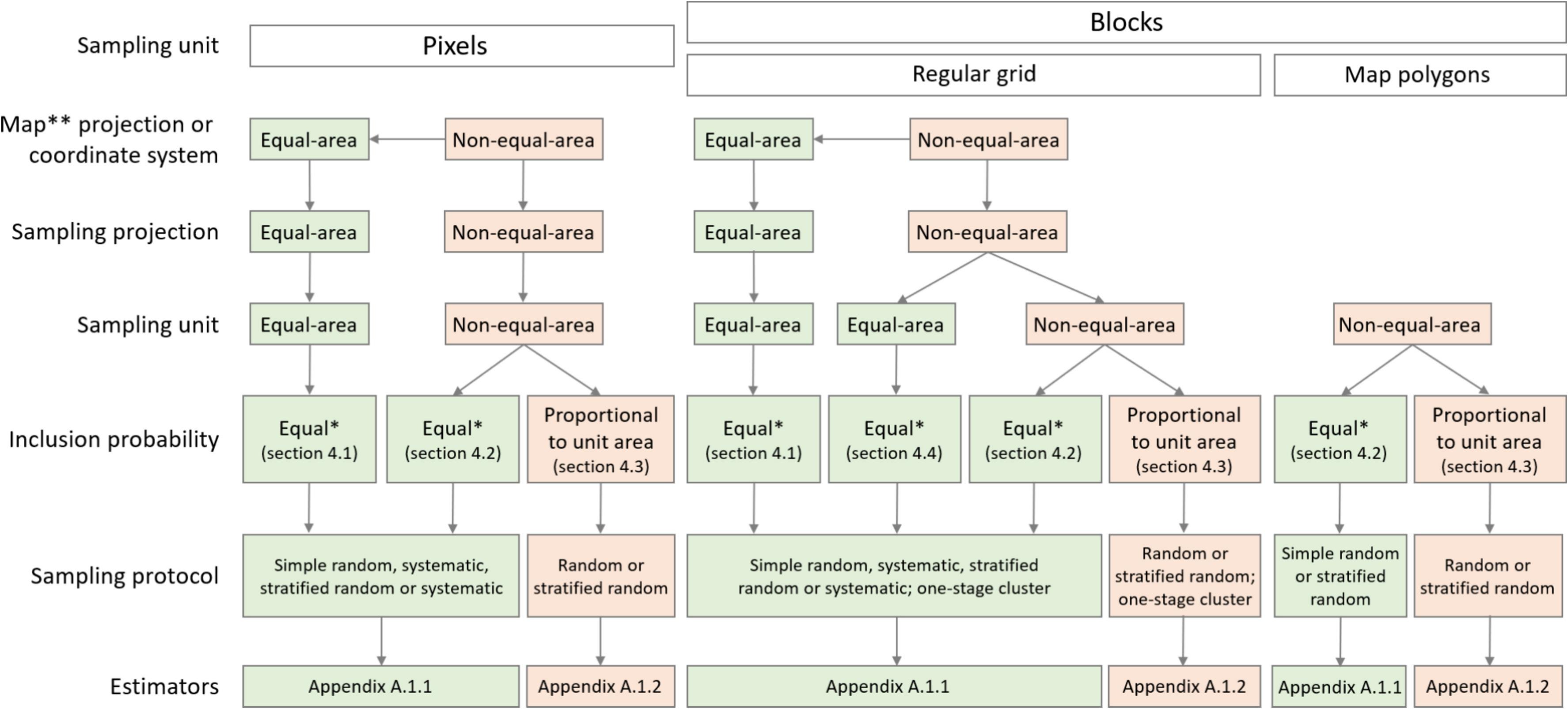
Figure: Sampling of discrete units for map accuracy and area estimation: probability sampling design options presented in the overview and a unified set of estimators. Specific sections referred to in the diagram discuss practical aspects of implementation and rationale for using each sampling option. This overview does not cover two-stage cluster sampling designs.
Published on Tue, 04/29/2025 - 15:55