
Principal Lecturer Jonathan Resop Makes Decade of Drone Lidar Data Publicly Available
High-resolution drone lidar surveys offer new opportunities to study stream restoration and landscape change.
Five drone lidar surveys documenting a stream restoration project in Virginia are now publicly available through OpenTopography, providing researchers and students with access to a rare, long-term record of environmental change.
Jonathan Resop, principal lecturer in the Department of Geographical Sciences (GEOG), led the effort to publish the datasets through OpenTopography after years of collaboration with Virginia Tech's StREAM Lab.
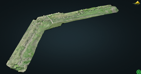
The datasets capture a 1.3-kilometer reach of Stroubles Creek in Blacksburg, Virginia, where researchers have monitored restoration efforts since 2010. The project compares multiple restoration approaches, including livestock exclusion, riparian vegetation planting, and natural channel design.
Collected using drone-based lidar, the surveys span nearly a decade, from 2017 to 2026. Drone lidar can capture more than 500 points per square meter, producing highly detailed three-dimensional representations of the landscape. These data help researchers measure changes in vegetation, stream channel morphology, and floodplain characteristics over time.
The newly released datasets include complete point clouds ranging from 80 million to 360 million points, along with high-resolution digital terrain and canopy height models.
“These datasets not only allow researchers to study a stream restoration site in high resolution, but also give students the opportunity to work with drone-based lidar data, which is typically not widely available and readily accessible.” Resop said.
Datasets
- Hession, W. C., L. Lehmann, and J. P. Resop. 2026. Virginia Tech StREAM Lab Spring 2017 Drone Lidar Survey. OpenTopography. https://doi.org/10.5069/G95X275P
- Hession, W. C., L. Lehmann, and J. P. Resop. 2026. Virginia Tech StREAM Lab Fall 2018 Drone Lidar Survey. OpenTopography. https://doi.org/10.5069/G9SQ8XN1
- Hession, W. C., L. Lehmann, T. Pingel, J. Czuba, E. Prior, N. Christensen, Y. Kobayashi, and J. P. Resop. 2023. Virginia Tech StREAM Lab Winter 2021 Drone Lidar Survey. OpenTopography. https://doi.org/10.5069/G9348HK3
- Hession, W. C., L. Lehmann, Y. Kobayashi, and J. P. Resop. 2026. Virginia Tech StREAM Lab Summer 2024 Drone Lidar Survey. OpenTopography. https://doi.org/10.5069/G9J67F57
- Hession, W. C., L. Lehmann, A. Chandel, and J. P. Resop. 2026. Virginia Tech StREAM Lab Spring 2026 Drone Lidar Survey. OpenTopography. https://doi.org/10.5069/G9NZ85W7
Image: 3-D point cloud for the Spring 2026 survey on OpenTopography showing RGB color values. Courtesy of Jonathan Resop
Published on Tue, 06/23/2026 - 14:14