
NASA Highlights Harmonized Landsat and Sentinel-2 Breakthrough
UMD researchers help advance a global dataset that improves disaster response, land-use monitoring and agricultural planning
NASA: "Harmonized Landsat and Sentinel-2: Collaboration Drives Innovation"
Introduction
Landsat, a joint program of NASA and the U.S. Geological Survey (USGS), has been an invaluable tool for monitoring changes in Earth’s land surface for over 50 years. Researchers use instruments on Landsat satellites to monitor decades-long trends, including urbanization and agricultural expansion, as well as short-term dynamics, including water use and disaster recovery. However, scientists and land managers often encounter one critical limitation of this program: Landsat has a revisit time of eight days (with Landsat 8 and 9 operating), which is too long to capture events and disasters that occur on short timescales. Floods, for example, can quickly inundate a region, and cloud cover from storms can delay Landsat’s ability to get a clear observation on damage.
...
HLS V2.0 in Action
The increased frequency of observations improved the ability of the scientific community to track disaster recovery, changes in phenology, agricultural intensification, rapid urban growth, logging, and deforestation. Researchers are already putting these advances to use.
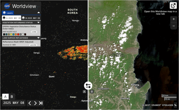
The land disturbance product (DIST-ALERT) is a global land change monitoring system that uses HLS V2.0 data to track vegetation anomalies in near real-time – see Figure 1. DIST-ALERT captures agricultural expansion, urban growth, fire, flooding, logging, drought, landslides, and other forces of change to vegetation. Amy Pickens [University of Maryland, Department of Geographical Sciences—Assistant Research Professor] said that HLS is the perfect dataset for tracking disturbances because of the frequency of observations.
DIST-ALERT was created through Observational Products for End-Users from Remote Sensing Analysis (OPERA), a project at NASA/Jet Propulsion Laboratory (JPL). OPERA products respond to agency needs identified by the SNWG. In 2018, SNWG identified tracking surface disturbance as a key need. OPERA partnered with the Global Land Analysis and Discovery (GLAD) lab at University of Maryland to develop the change detection algorithm. ...
NASA Article in Full
Image: Wildfires in South Korea (March 2025) caused major vegetation loss. [Left] DIST-ALERT data on May 8 show losses under 50% (yellow) and over 50% (red). [Right] A Sentinel-2C image the same day reveals the large burn scar amid surrounding green vegetation. Credit: UMD-GLAD
Related Article
GLAD’s DIST ALERT Spotlighted in NASA’s Image of the Week
Published on Thu, 08/28/2025 - 14:33