Innovative System Puts Maryland at the Forefront of Carbon Monitoring
Integrated geospatial mapping and modeling offer a new method for tracking forest carbon and climate goals.
Forests have long helped maintain Earth’s sustainability by absorbing carbon dioxide and releasing oxygen. However, tracking exactly how much carbon they store—and how and why this changes over time—is a complex challenge.
Led by Professor George Hurtt, researchers from the Department of Geographical Sciences, state of Maryland, NASA, World Resources Institute, US Forest Service and others have developed an innovative methodology to address this challenge. By combining data from satellites and aerial sensors with advanced computer models, they have created a new method to monitor changes in forest carbon levels. This approach, published in Environmental Research Letters, provides high-resolution maps of Maryland’s forest carbon changes from 1984 to 2023.
“This study effectively demonstrates how scientific advancements can enhance state-level operations,” said paper co-author Elliot Campbell, director of Economic and Social Science in the Maryland Department of Natural Resources. “This work will hopefully inspire increased interest and collaboration across other states.”
Maryland has become the first state in the nation to deploy a remote-sensing-based system for forest carbon monitoring and modeling. The University of Maryland, through its Campus Forest Carbon Project, is the first university to adopt this innovative approach.
The new system captures changes in above-ground carbon in high detail over all Maryland’s forests, tracking changes in 27 million 30-meter grid cells in the state. By covering nearly four decades, the team has tracked how weather patterns, CO₂ levels, disturbances like storms and land use and subsequent regrowth have impacted carbon storage.
Key Findings
- Maryland's forests function as a net carbon sink, though there is considerable spatial and temporal variability.
- Persistent and regrowing forests, reduced disturbance and rising CO2 primarily contributed to the long-term statewide sink, while weather and variable disturbances primarily contributed to the large-scale interannual variability.
- Spatial patterns of forest carbon dynamics varies across the state, with the majority of locations gaining carbon and a smaller fraction losing carbon during disturbance events.
“The wall-to-wall geospatial coverage afforded by this approach enabled the consistent monitoring and reporting of results across multiple relevant spatial (state, county, event) and temporal scales (annual, decadal)— all in a framework also enabled for planning,” said Hurtt. “This is critical for informing the state’s policies and planning for greenhouse gas reductions.”
Rachel Lamb, co-author of the study and senior climate advisor at the Maryland Department of the Environment, echoed Hurtt’s insights:
"This team’s work represents a leap forward in using advanced modeling and remote sensing technologies together to map forest carbon changes and provide insight into the causes behind these changes. This kind of attribution is critical for targeted climate policy and planning.”
- Rachel Lamb, Maryland Department of the Environment
As a key partner in the project, Lamb played a vital role in ensuring the research met Maryland’s specific policy needs.
Maryland’s Forests: A Vital Carbon Sink
Statewide, forested land had an average annual net carbon sink comparable to prior estimates, removing about 1.37 million tons of carbon annually. However, this role is not static.
“Our research found that while forests consistently take in carbon, their rate of absorption can fluctuate significantly from year to year and place to place,” Hurtt explained. “Previous approaches reported only long-term trends.”
Persistent, undisturbed forests contributed the most to the carbon sink, while newly regrowing forests played a smaller but significant role. Disturbances like logging, wildfires or major storms had a substantial impact on these dynamics.
Tools for Climate Action
The study’s implications go beyond discovery. It offers critical data to help Maryland’s policymakers achieve ambitious carbon reduction goals.
“Our system not only allows for precise monitoring of forest carbon changes but also enables future planning for better forest management and climate policy,” said Hurtt.
Developed at UMD in collaboration with the state of Maryland, the system was designed to meet the state’s needs for comprehensive forest carbon monitoring and planning.
The data has already been used to inform Maryland’s climate strategies, including the state’s plan to achieve net zero greenhouse gas emissions by 2045 and the 5 Million Trees Initiative, which aims to plant and maintain five million trees by 2031.
A Model for Others
Maryland’s approach is intended to serve as a scalable model for other states, regions and countries. “With NASA support, the system is also being developed to run globally as a prototype for broader adoption,” said Hurtt.
With new satellite missions and advancing technologies, the potential for more detailed carbon monitoring is growing, enabling improved data, smarter policies and stronger global climate action.
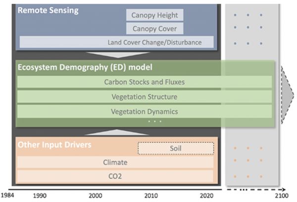
Image: Conceptual diagram of the components of the forest carbon monitoring and modeling system. Remote sensing and other input drivers are integrated into the Ecosystem Demography model to quantify past vegetation structure, dynamics and carbon stocks and fluxes over the state consistent with contemporary baseline conditions.
Beyond MRV: Combining Remote Sensing and Ecosystem Modeling for Geospatial Monitoring and Attribution of Forest Carbon Fluxes over Maryland, USA. George C Hurtt, Lei Ma, Rachel Lamb, Elliot Campbell, Ralph O Dubayah, M Hansen, Chengquan Huang, Haley Leslie-Bole, Andrew Lister, Jiaming Lu, Frances Marie S Panday, Quan Shen, Carlos E Silva and H Tang. Environmental Research Letters, Volume 19, Number 12
Published on Thu, 12/05/2024 - 15:16


