UMD College of Behavorial & Social Sciences UMD College of Behavorial & Social Sciences
MENU

Topbar Menu

  • About Us
  • People
  • Alumni and Giving
  • Diversity
  • Undergraduate
    • Prospective Students
    • Courses & Facilities
    • Advising
    • Special Programs
    • Graduation
    • Geography Club
  • Graduate
    • Prospective Ph.D. Students
    • Graduate Courses
    • Graduate Student Publications
    • Graduate Student Awards
    • Graduate Students
    • Master of Science and Graduate Certificate Programs
    • Combined BS/MS Program
  • Research
    • Research Areas
      • Geospatial-Information Science and Remote Sensing
      • Human Dimensions of Global Change
      • Land Cover and Land Use Change
      • Carbon, Vegetation Dynamics and Landscape-Scale Processes
    • Centers
      • Center for Geospatial Information Science
      • International Center for Innovation in Geospatial Analytics & Earth Observation
  • High School Hub
    • Program Overview
    • High School Awards
    • High School Internship Program
    • GIS Day
  • Resources
    • Graduate Student Organization
    • Student Life
    • Graduate School
    • Responsible Conduct of Research
    • Emergency Preparedness
    • Job Opportunities
    • Graduation
Search

Main navigation

  • Undergraduate
    • Prospective Students
    • Courses & Facilities
    • Advising
    • Special Programs
    • Graduation
    • Geography Club
  • Graduate
    • Prospective Ph.D. Students
    • Graduate Courses
    • Graduate Student Publications
    • Graduate Student Awards
    • Graduate Students
    • Master of Science and Graduate Certificate Programs
    • Combined BS/MS Program
  • Research
    • Research Areas
      • Geospatial-Information Science and Remote Sensing
      • Human Dimensions of Global Change
      • Land Cover and Land Use Change
      • Carbon, Vegetation Dynamics and Landscape-Scale Processes
    • Centers
      • Center for Geospatial Information Science
      • International Center for Innovation in Geospatial Analytics & Earth Observation
  • High School Hub
    • Program Overview
    • High School Awards
    • High School Internship Program
    • GIS Day
  • Resources
    • Graduate Student Organization
    • Student Life
    • Graduate School
    • Responsible Conduct of Research
    • Emergency Preparedness
    • Job Opportunities
    • Graduation
  • About Us
  • People
  • Alumni and History
  • Diversity

Search our site:

Improving Forest Biomass Estimation Techniques With GEDI

Breadcrumb

  • Home
  • Featured Content
  • Improving Forest Biomass Estimation Techniques With GEDI
Impact of GEDI data sparsity in the paring of NFI plots to the most adjacent GEDI footprint. Data sparsity is a function on the density of GEDI tracks, the proportion of cross-tracks and the effect of quality filters at reducing the number of high-quality GEDI footprints along each ground track.

A recent paper outlines approaches to tailor GEDI biomass estimates to local conditions. 

Estimating the biomass of forests—the total amount of living organic matter in a forest— across vast and diverse landscapes has long challenged geographical scientists. A recent benchmarking study using NASA's Global Ecosystem Dynamics Investigation (GEDI) mission points to available solutions to this complex problem.

Published in the Journal of Environmental Management, the paper compared three approaches to improve biomass estimation, identifying one as the most effective. The study also serves as a guide for GEDI data users, offering insights on how to recalibrate global GEDI estimates to align with site-specific field inventory plots.

"When estimating forest biomass using GEDI satellite data, a statistical technique called imputation—which fills in missing or uncertain data based on patterns in existing data—produces better results than simply relying on GEDI measurements from nearby locations," explained lead author of the paper Adrián Pascual, who has been recently promoted to associate research professor at the Department of Geographical Sciences.

Examining Mediterranean forests in Spain, Pascual and colleagues discovered that the geostatistical imputation method offers specific advantages such as less sensitivity to geolocation errors in forest inventory data; potential to improve biomass predictions in some scenarios; and ability to use multiple satellite data points for more comprehensive measurements.

"Instead of assuming that areas close to each other have similar biomass just because they are adjacent, the study found that using statistical models to predict biomass based on a combination of GEDI data and ground measurements can perform better. The approach is not contingent on expensive airborne lidar data availability, and this provides countries flexibility to re-design their own GEDI models for biomass but also other variables such as stock volume or basal area - key metrics for forest management,” explained Pascual.

With continued refinement of these methods, forest monitoring is expected to improve, contributing to more effective conservation efforts globally. The assimilation of GEDI data into applications is evolving steadily over the past six  years since GEDI collected its first measurement in 2019.

Full paper

“Calibration of GEDI Footprint Aboveground Biomass Models in Mediterranean Forests With NFI Plots: A Comparison of Approaches.” Adrián Pascual, Paul B. May, Aarón Cárdenas-Martínez, Juan Guerra-Hernández, Neha Hunka, Jamis M. Bruening, Sean P. Healey, John D. Armston, Ralph O. Dubayah. Journal of Environmental Management, 375, 124313. https://doi.org/10.1016/j.jenvman.2025.124313 

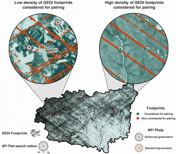
Image: Impact of GEDI data sparsity in the paring of NFI plots to the most adjacent GEDI footprint. Data sparsity is a function on the density of GEDI tracks, the proportion of cross-tracks and the effect of quality filters at reducing the number of high-quality GEDI footprints along each ground track.
 

Published on Fri, 03/28/2025 - 11:13

College of Behavorial & Social Sciences
  • Facebook
  • Twitter
  • Instagram
  • YouTube
  • LinkedIn
  • Zenfolio

Department of Geographical Sciences

2181 Samuel J. LeFrak Hall, 7251 Preinkert Drive,
University of Maryland, College Park, MD 20742
Phone: 301-405-4050

Join Our Newsletter

Contact Us

Links
  • UMD Land Acknowledgement
  • UMD Staff Directory
  • Give to GEOG
  • UMD Web Accessibility
  • Alumni
© 2025 College of Behavorial & Social Sciences. All Rights Reserved.
Login