
How Longstanding Russia-Ukraine Conflict Has Impacted Conservation Efforts
The war between Russia and Ukraine has been happening since 2014; Russia’s invasion of Ukraine in February 2022 was only a recent escalation.
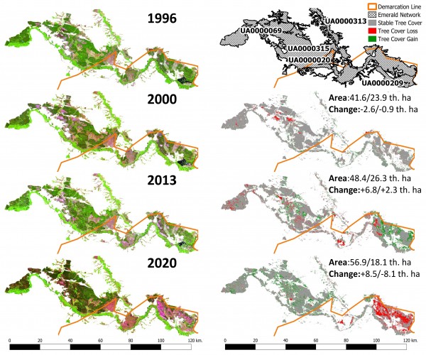
As the two sides have been at odds with each other for nearly a decade now, a team of researchers in the University of Maryland’s Department of Geographical Sciences, including Ph.D student Leonid Shumilo, Associate Chair George Hurtt, Associate Professor Meredith Gore and Associate Professor Sergii Skakun and recently set out to see how the ongoing conflict has impacted key conservation areas—specifically those that are a part of the “Emerald Network,” an ecological network of areas of special conservation interest as identified by the Bern Convention. The Bern Convention, aka a Convention on the Conservation of European Wildlife and Natural Habits, is a regional convention whose aim is to conserve wild flora and fauna and their natural habitats in Europe and parts of Africa.
As published in Communications Earth & Environment, the researchers—along with experts from, the Department of Mathematical Modelling and Data Analysis of the National Technical University of Ukraine (NTUU), Ukraine’s Space Research Institute, and the Ukrainian NGO “ForestCom”—found that there was a transition from deforestation (-4% each) to substantial reforestation (+8% and +10%) on both sides of the Luhansk region’s Emerald Network site, which was divided by the demarcation line in 2014, after Bern Convention conservation policies were implemented in 2000.
“We used historical satellite images from the Landsat and Sentinel data collections to build land cover classification maps from 1996 to 2020 for the Luhansk region,” said Shumilo, a Ph.D. student in the Department of Geographical Sciences and the paper’s leading author. “These maps allowed us to conduct an analysis of the deforestation pressure of Ukrainian Emerald Network policies and the separation of local institutions due to the partial occupation of the Luhansk region by the Russian Federation in 2014,” Shumilo explained.
The study also highlights the impact of the war on territories under Ukrainian and Russian control post-2014. The researchers also found that, despite challenging circumstances, territories under Ukrainian control after 2014 continued to experience reforestation (+9%), while territories under Russian control experienced a severe loss of forests (-25%).
“These trends underscore many of the detrimental consequences emerging from separation of local institutions on conservation areas and the positive effect of the forest management practices implemented during establishment of the Emerald Network," said Skakun, who holds a joint appointment with the College of Information Studies (iSchool).
Modern technology made much of these research insights possible.
“The combination of Ukrainian AI potential with American satellite monitoring experience allows us to address many cornerstone scientific problems in international cooperation,” said Professor Nataliia Kussul of the NTUU, who headed the Ukrainian research team. “In this study machine learning land cover classification methods developed in Ukraine in national and international programs helped us quantify changes in war-impacted areas, not accessible for ground surveys due to active warfare.”
The researchers believe that these insights will contribute to a broader understanding of the relationship between armed conflicts and environmental conservation, ultimately guiding future efforts to safeguard our planet's biodiversity.
Map courtesy of Leonid Shumilo
Published on Thu, 11/30/2023 - 10:26