UMD College of Behavorial & Social Sciences UMD College of Behavorial & Social Sciences
MENU

Topbar Menu

  • About Us
  • People
  • Alumni and Giving
  • Diversity
  • Undergraduate
    • Prospective Students
    • Courses & Facilities
    • Advising
    • Special Programs
    • Graduation
    • Geography Club
  • Graduate
    • Prospective Ph.D. Students
    • Graduate Courses
    • Graduate Student Publications
    • Graduate Student Awards
    • Graduate Students
    • Master of Science and Graduate Certificate Programs
    • Combined BS/MS Program
  • Research
    • Research Areas
      • Geospatial-Information Science and Remote Sensing
      • Human Dimensions of Global Change
      • Land Cover and Land Use Change
      • Carbon, Vegetation Dynamics and Landscape-Scale Processes
    • Centers
      • Center for Geospatial Information Science
      • International Center for Innovation in Geospatial Analytics & Earth Observation
  • High School Hub
    • Program Overview
    • High School Awards
    • High School Internship Program
    • GIS Day
  • Resources
    • Graduate Student Organization
    • Student Life
    • Graduate School
    • Responsible Conduct of Research
    • Emergency Preparedness
    • Job Opportunities
    • Graduation
Search

Main navigation

  • Undergraduate
    • Prospective Students
    • Courses & Facilities
    • Advising
    • Special Programs
    • Graduation
    • Geography Club
  • Graduate
    • Prospective Ph.D. Students
    • Graduate Courses
    • Graduate Student Publications
    • Graduate Student Awards
    • Graduate Students
    • Master of Science and Graduate Certificate Programs
    • Combined BS/MS Program
  • Research
    • Research Areas
      • Geospatial-Information Science and Remote Sensing
      • Human Dimensions of Global Change
      • Land Cover and Land Use Change
      • Carbon, Vegetation Dynamics and Landscape-Scale Processes
    • Centers
      • Center for Geospatial Information Science
      • International Center for Innovation in Geospatial Analytics & Earth Observation
  • High School Hub
    • Program Overview
    • High School Awards
    • High School Internship Program
    • GIS Day
  • Resources
    • Graduate Student Organization
    • Student Life
    • Graduate School
    • Responsible Conduct of Research
    • Emergency Preparedness
    • Job Opportunities
    • Graduation
  • About Us
  • People
  • Alumni and History
  • Diversity

Search our site:

Bridging Science-Policy Gap for UNFCCC

Breadcrumb

  • Home
  • Featured Content
  • Bridging Science-Policy Gap For UNFCCC
Bridging the science-policy gap for UNFCCC

Scientists at the Department of Geographical Sciences (UMD GEOG) will be working toward the uptake of space-based forest carbon maps to inform the Global Stocktake of United Nations Framework Convention on Climate Change (UNFCCC).  

In a recently awarded NASA Carbon Monitoring System (CMS) three-year grant, Laura Duncanson (Principle Investigator, PI) and Neha Hunka (Science PI) will guide nations of the world on the operational use of carbon maps, modeled from data acquired from space, for policy reporting. 

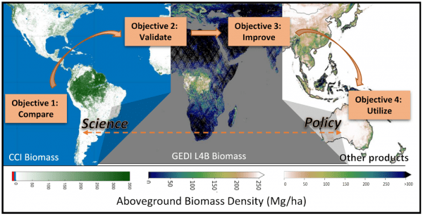
The proposed research is positioned to fill a fundamental gap in science and policy; the use of space-based carbon maps, such as those produced by the GEDI mission, to inform national and global policy is nearly non-existent as of 2023. In the awarded NASA CMS grant, researchers will compare carbon maps published by various space agencies and institutions, validate them using robust methods, test a suite of options to improve the maps with ground and airborne data, and co-develop practical tools to facilitate the uptake of maps by nations. The overarching goal is to support the formal incorporation of space-based carbon estimates to inform the Global Stocktake in 2025/26.  

The research is supported by the NASA-ESA Multi-mission Algorithm and Analysis Platform (MAAP), based on open-science policies with the codes publicly released during the course of the project. The outcomes are expected to set the stage for maps from future missions, such as NASA-ISRO’s Synthetic Aperture Radar (NISAR) and the European Space Agency’s BIOMASS mission, to be seamlessly used for the collective global ambition of reducing forest carbon emissions.


Published on Tue, 06/06/2023 - 23:18

College of Behavorial & Social Sciences
  • Facebook
  • Twitter
  • Instagram
  • YouTube
  • LinkedIn
  • Zenfolio

Department of Geographical Sciences

2181 Samuel J. LeFrak Hall, 7251 Preinkert Drive,
University of Maryland, College Park, MD 20742
Phone: 301-405-4050

Join Our Newsletter

Contact Us

Links
  • UMD Land Acknowledgement
  • UMD Staff Directory
  • Give to GEOG
  • UMD Web Accessibility
  • Alumni
© 2025 College of Behavorial & Social Sciences. All Rights Reserved.
Login