
Bridging the Gap Between Satellites and Farms: UMD MS Student Reports from AFS 2025
Leaders learned how UMD researchers are applying geospatial data to track environmental change and support communities worldwide.
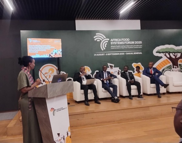
The University of Maryland's NASA Harvest, XylemLab and the Common Market for Eastern and Southern Africa (COMESA) hosted a special side event at the Africa's Food Systems (AFS) Forum 2025 in Senegal. The session, titled “Crop Production Estimation Using Satellite Data and Machine Learning for Regional Food Balance and Security Monitoring,” brought together experts, policymakers and youth innovators to explore how geospatial technologies can be transformed into practical tools that strengthen agricultural decision-making and food security across Africa.
The conversation opened with Sixbert Maurice, senior lecturer at Sokoine University in Tanzania, who highlighted the persistent disconnect between regional satellite analyses and the realities of smallholder farmers. He described three key gaps — scale, interpretation and accessibility — noting that while satellite data can map entire landscapes, “farmers need guidance at the plot level.” Maurice emphasized that digital tools must move beyond presenting raw vegetation indices or model outputs. Instead, they should translate complex measurements into clear recommendations, such as when to plant maize or apply inputs based on forecasted rainfall. He stressed that for technology to be impactful, it must “speak the farmer’s language” and deliver advice that fits local decision timelines.
Building on this, Edrick Bwambale from the Sustainable Agri-Food Initiative in Uganda offered the perspective of youth innovators working directly with farmers. He reflected on the overwhelming and often conflicting information farmers receive from meteorological agencies, NGOs and local actors, noting that the challenge is rarely the sophistication of the technology but rather its accessibility and credibility. “You approach a farmer in hopes of sharing what we’re supposed to do … yet you don’t know which piece of information you should rely on or which one is credible enough to trust,” he said. Bwambale described interventions in Uganda where soil moisture sensors linked with satellite data provided precise guidance on irrigation scheduling — a technology farmers quickly adopted because it was simple, actionable and directly tied to improved yields. “The end goal is for the farmer to understand that this information is going to improve production,” he added.
From a government coordination perspective, Albert Novas Somanje of the Zambian Ministry of Agriculture described ongoing efforts to close data gaps that inhibit effective agricultural planning. He explained that while Zambia collaborates with the Meteorological Department to produce biweekly agro-meteorological bulletins, delays in generating recommendations mean farmers often receive information too late to act upon it. “Currently, it takes about 10 days, but our goal is five days or fewer,” he said. He emphasized the need for harmonized data frameworks aligned with agricultural zones rather than only administrative boundaries to improve both the quality of national statistics and the relevance of field-level recommendations.

Collage of images from AFS 2025 in Dakar, Senegal.
This theme of harmonization was further explored by Assistant Professor Catherine Nakalembe at the Department of Geographical Sciences, who drew lessons from Kenya’s transition from manual, list-based farmer sampling to GIS-based sampling frames for crop insurance programs. She described how this shift allowed Kenya to produce spatially explicit and nationally representative crop data, reducing uncertainty and improving the accuracy of production estimates. Nakalembe emphasized that with sufficient investment, similar approaches could significantly strengthen crop monitoring systems in other countries and support more reliable regional food balance assessments.
Putting these national perspectives into a broader context, Patrick Maingi from the COMESA Secretariat discussed the role of the Regional Food Balance Sheet (RFBS) in harmonizing crop production estimates across member states. He noted that inconsistent definitions — for example, what constitutes a hectare of maize or how yields are calculated — and delays in reporting often distort regional markets and contribute to price speculation. Rwanda and Kenya, he said, have emerged as strong examples for their coordinated statistical systems: Rwanda has integrated remote sensing into agricultural surveys and publishes harmonized, publicly accessible data, while Kenya demonstrates effective collaboration across multiple agricultural agencies. Maingi highlighted ongoing efforts to expand the RFBS to additional countries, including Ethiopia, Burundi and Zimbabwe, and to incorporate new crops such as wheat, millet, sorghum and soybean — reinforcing the importance of collaboration and standardized methodologies for regional food security.
Together, the insights shared during the side event underscored a unifying message: satellite data and machine learning hold tremendous potential to transform agricultural monitoring, but their impact depends on the systems that translate them into action. From simplifying digital tools for farmers to strengthening national and regional data frameworks to ensuring consistent definitions and coordination across borders, the path forward requires a blend of scientific innovation and institutional collaboration. As the speakers emphasized, building trusted, accessible and harmonized data ecosystems will be essential for helping farmers make informed decisions and for strengthening food security across Africa.
Main image: Speakers at the side event, from left: Catherine Nakalembe (host), Patrick Maingi, Sixbert Maurice, Edrick Bwambale and Albert Novas Somanje. All photos provided by Nakalembe, the speakers and AFS 2025 organizers.
This article was written by Monica Adjei, MSGIS-UMD.
Published on Sun, 11/23/2025 - 09:59