UMD College of Behavorial & Social Sciences UMD College of Behavorial & Social Sciences
MENU

Topbar Menu

  • About Us
  • People
  • Alumni and Giving
  • Diversity
  • Undergraduate
    • Prospective Students
    • Courses & Facilities
    • Advising
    • Special Programs
    • Graduation
    • Geography Club
  • Graduate
    • Prospective Ph.D. Students
    • Graduate Courses
    • Graduate Student Publications
    • Graduate Student Awards
    • Graduate Students
    • Master of Science and Graduate Certificate Programs
    • Combined BS/MS Program
  • Research
    • Research Areas
      • Geospatial-Information Science and Remote Sensing
      • Human Dimensions of Global Change
      • Land Cover and Land Use Change
      • Carbon, Vegetation Dynamics and Landscape-Scale Processes
    • Centers
      • Center for Geospatial Information Science
      • International Center for Innovation in Geospatial Analytics & Earth Observation
  • High School Hub
    • Program Overview
    • High School Awards
    • High School Internship Program
    • GIS Day
  • Resources
    • Graduate Student Organization
    • Student Life
    • Graduate School
    • Responsible Conduct of Research
    • Emergency Preparedness
    • Job Opportunities
    • Graduation
Search

Main navigation

  • Undergraduate
    • Prospective Students
    • Courses & Facilities
    • Advising
    • Special Programs
    • Graduation
    • Geography Club
  • Graduate
    • Prospective Ph.D. Students
    • Graduate Courses
    • Graduate Student Publications
    • Graduate Student Awards
    • Graduate Students
    • Master of Science and Graduate Certificate Programs
    • Combined BS/MS Program
  • Research
    • Research Areas
      • Geospatial-Information Science and Remote Sensing
      • Human Dimensions of Global Change
      • Land Cover and Land Use Change
      • Carbon, Vegetation Dynamics and Landscape-Scale Processes
    • Centers
      • Center for Geospatial Information Science
      • International Center for Innovation in Geospatial Analytics & Earth Observation
  • High School Hub
    • Program Overview
    • High School Awards
    • High School Internship Program
    • GIS Day
  • Resources
    • Graduate Student Organization
    • Student Life
    • Graduate School
    • Responsible Conduct of Research
    • Emergency Preparedness
    • Job Opportunities
    • Graduation
  • About Us
  • People
  • Alumni and History
  • Diversity

Search our site:

Woody Vegetation Dataset for Latin America Released

Breadcrumb

  • Home
  • Featured Content
  • Woody Vegetation Dataset For Latin America Released
The map shows percent tall woody cover (> 5m tall) in shades of green ((0 to 100%, light to dark green), short woody vegetation cover (<5 m) in white, woody vegetation cover decrease in red, and decrease - in blue

Annual data from 2015 to 2023 provides detailed insights into tree canopy cover and height.

A team of scientists, led by Research Professor Peter Potapov, has released the Latin America Woody Vegetation Structure and Change (LAM WVSC) dataset, designed to support forest management, conservation and restoration in Latin America. The dataset covers the period from 2015 to 2023 and offers data on woody vegetation structure at a resolution of 30 meters per pixel.

Addressing Data Gaps

Existing land cover maps and forest loss datasets often do not provide detailed information on vegetation structure, such as tree canopy cover and height, especially in savannas and dry woodlands, explained the dataset release.The LAM WVSC dataset addresses this by offering annual data on the structure of forests, woodlands, and savannas. Even short and open woodlands, with a canopy cover of 10% and tree height of 2 m are reflected by this new dataset. The new data will support biomass modeling, greenhouse gas emission estimates and forest restoration planning.

Methodology

The dataset was developed through a collaboration between scientists at Global Land Analysis & Discovery (UMD-GLAD), the World Resources Institute and Brazil’s National Institute for Space Research using these methods:

  • Landsat Analysis Ready Data (ARD): Used for accuracy and consistency.
  • Annual Phenology and Change Detection Features: Employed to monitor vegetation dynamics.
  • Locally Calibrated Regression Tree Ensemble Models: Utilized for detailed structure mapping.
  • Temporal Filtering Techniques: Applied to enhance interannual map consistency.

Access and Availability

The dataset is freely available under the Creative Commons Attribution License (CC BY). It can be accessed as raster image tiles or as public assets on Google Earth Engine. An interactive platform for viewing the data is available.

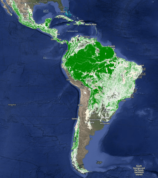
Image: The map shows percent tall woody cover (> 5m tall) in shades of green ((0 to 100%, light to dark green), short woody vegetation cover (<5 m) in white, woody vegetation cover decrease in red, and decrease - in blue. Courtesy of the Global Land Analysis & Discovery (UMD-GLAD) group.
 

Published on Thu, 01/16/2025 - 15:41

College of Behavorial & Social Sciences
  • Facebook
  • Twitter
  • Instagram
  • YouTube
  • LinkedIn
  • Zenfolio

Department of Geographical Sciences

2181 Samuel J. LeFrak Hall, 7251 Preinkert Drive,
University of Maryland, College Park, MD 20742
Phone: 301-405-4050

Join Our Newsletter

Contact Us

Links
  • UMD Land Acknowledgement
  • UMD Staff Directory
  • Give to GEOG
  • UMD Web Accessibility
  • Alumni
© 2025 College of Behavorial & Social Sciences. All Rights Reserved.
Login