UMD College of Behavorial & Social Sciences UMD College of Behavorial & Social Sciences
MENU

Topbar Menu

  • About Us
  • People
  • Alumni and Giving
  • Diversity
  • Undergraduate
    • Prospective Students
    • Courses & Facilities
    • Advising
    • Special Programs
    • Graduation
    • Geography Club
  • Graduate
    • Prospective Ph.D. Students
    • Graduate Courses
    • Graduate Student Publications
    • Graduate Student Awards
    • Graduate Students
    • Master of Science and Graduate Certificate Programs
    • Combined BS/MS Program
  • Research
    • Research Areas
      • Geospatial-Information Science and Remote Sensing
      • Human Dimensions of Global Change
      • Land Cover and Land Use Change
      • Carbon, Vegetation Dynamics and Landscape-Scale Processes
    • Centers
      • Center for Geospatial Information Science
      • International Center for Innovation in Geospatial Analytics & Earth Observation
  • High School Hub
    • Program Overview
    • High School Awards
    • High School Internship Program
    • GIS Day
  • Resources
    • Graduate Student Organization
    • Student Life
    • Graduate School
    • Responsible Conduct of Research
    • Emergency Preparedness
    • Job Opportunities
    • Graduation
Search

Main navigation

  • Undergraduate
    • Prospective Students
    • Courses & Facilities
    • Advising
    • Special Programs
    • Graduation
    • Geography Club
  • Graduate
    • Prospective Ph.D. Students
    • Graduate Courses
    • Graduate Student Publications
    • Graduate Student Awards
    • Graduate Students
    • Master of Science and Graduate Certificate Programs
    • Combined BS/MS Program
  • Research
    • Research Areas
      • Geospatial-Information Science and Remote Sensing
      • Human Dimensions of Global Change
      • Land Cover and Land Use Change
      • Carbon, Vegetation Dynamics and Landscape-Scale Processes
    • Centers
      • Center for Geospatial Information Science
      • International Center for Innovation in Geospatial Analytics & Earth Observation
  • High School Hub
    • Program Overview
    • High School Awards
    • High School Internship Program
    • GIS Day
  • Resources
    • Graduate Student Organization
    • Student Life
    • Graduate School
    • Responsible Conduct of Research
    • Emergency Preparedness
    • Job Opportunities
    • Graduation

Search our site:

What do we know about forest degradation in Africa?

Breadcrumb

  • Home
  • Featured Content
  • What Do We Know About Forest Degradation In Africa?
Charcoal  production in Mozambique


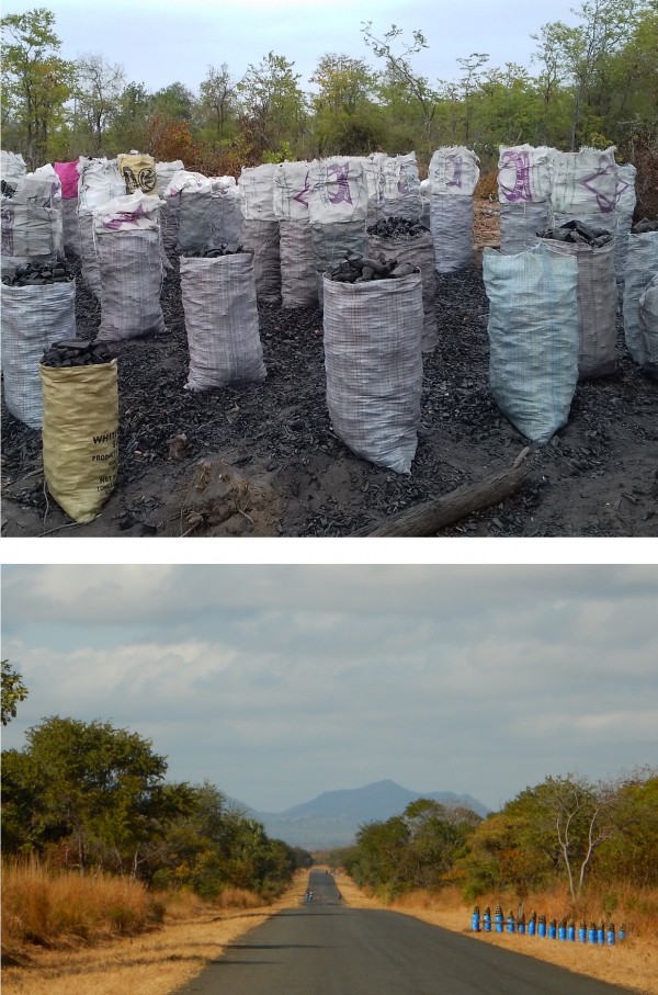
Charcoal is an essential element of every day’s life in African cities, where it is used as cooking fuel by close to eighty percent of households. Charcoal is the result of a process in which logs and branches piled in kilns are carbonized under low oxygen combustion conditions. Most of this charcoal is produced from natural forests and woodlands, and the process is considered the main cause of forest degradation in sub-Saharan Africa. Recent studies in the region indicate that charcoal production could remove between 60 and 80 % of the standing aboveground biomass, representing up to 30 % of the total emissions from forest loss in tropical woodlands of sub-Saharan Africa. As the urbanization process in Africa intensifies, the growing demand for charcoal will pose an increasing pressure on African woodlands.


However, despite the magnitude of its present and future potential impact, forest degradation from charcoal production is still insufficiently understood and poorly quantified. With support from the NSF Coupled Natural and Human Systems and NASA Carbon Monitoring Systems programs, a group of international researchers lead by Dr. Fernando Sedano is developing remote sensing-based and modeling tools to characterize, monitor, quantify and forecast the impact of forest degradation associated with charcoal production in the tropical woodlands of sub-Saharan Africa. The team uses multitemporal datasets of medium, high, and very high resolution optical remote sensing data to map the extent and intensity of forest degradation due to charcoal production. Their work also combines remote sensing and ecosystem modeling to forecast potential forest regrowth trajectories under various charcoal production scenarios.


Working closely with stakeholder in the region, this research supports the development of more precise MRV REDD+ systems in sub-Saharan Africa and provides key information for decision makers and efficient policy interventions. The methods developed in this project will also enable the independent monitoring of emission inventories in support of international climate agreements.

Published on Wed, 09/16/2020 - 09:13

College of Behavorial & Social Sciences
  • Facebook
  • Twitter
  • Instagram
  • YouTube
  • LinkedIn
  • Zenfolio

Department of Geographical Sciences

2181 Samuel J. LeFrak Hall, 7251 Preinkert Drive,
University of Maryland, College Park, MD 20742
Phone: 301-405-4050

Join Our Newsletter

Contact Us

Links
  • UMD Land Acknowledgement
  • UMD Staff Directory
  • Give to GEOG
  • UMD Web Accessibility
  • Alumni
© 2025 College of Behavorial & Social Sciences. All Rights Reserved.
Login