
UMD Study: While Some Forest Losses Recover, Others Permanently Lost
UMD’s Global Land Analysis and Discovery (GLAD) Lab uses high-resolution satellite data to quantify global forest change in unprecedented detail.
From cattle pasture expansion in the Amazon to oil palm plantations in Southeast Asia, forests disappear—and some of those losses appear to be permanent. A new study from the University of Maryland’s Global Land Analysis and Discovery (GLAD) Lab found that nearly one-third of the world’s tree cover loss in 2018 resulted in permanent forest conversion, offering the clearest picture yet of where forests disappear and where they are expected to recover over time.
Published June 4 in Science, the research used a global sample of high-resolution imagery at 3 to 10 meters to quantify the extent, and drivers of tree cover changes around the world. The team estimated that a total of about 277,000 square kilometers of tree cover—an area roughly the size of Arizona—was lost worldwide in 2018.
Researchers focused on 2018 because distinguishing permanent forest conversion from temporary tree cover loss requires several years of follow-up observation.
“Accurate knowledge on the scale of economic activities and natural phenomena that remove forest cover is lacking at the global scale,” said Matthew Hansen, a professor in the Department of Geographical Sciences (GEOG) and UMD’s GLAD director. “This study is the most precise quantification to date and sets a methodological framework and baseline record that can be built upon over time in tracking this critical dynamic.”
Nearly one-third of the total tree cover loss represented permanent conversion of forests and woodlands to other land uses, while the remaining losses resulted from temporary disturbances such as forestry operations, shifting agriculture and wildfires, in which trees are expected to regenerate over time.
“It is important to differentiate between permanent and temporary tree cover loss because these categories are very different in terms of environmental consequences,” said Alexandra (Sasha) Tyukavina, lead author of the study and an associate research professor in GEOG. “Widely used maps—like the annual tree cover loss map produced by our lab and published on Global Forest Watch—do not make this distinction.”
Nearly two-thirds of global tree cover loss occurred in the tropics. Latin America accounted for the largest share at 26.6%, followed by South and Southeast Asia at 21.6% and Africa at 18.2%. Brazil, Russia and Indonesia experienced the greatest losses among individual countries.
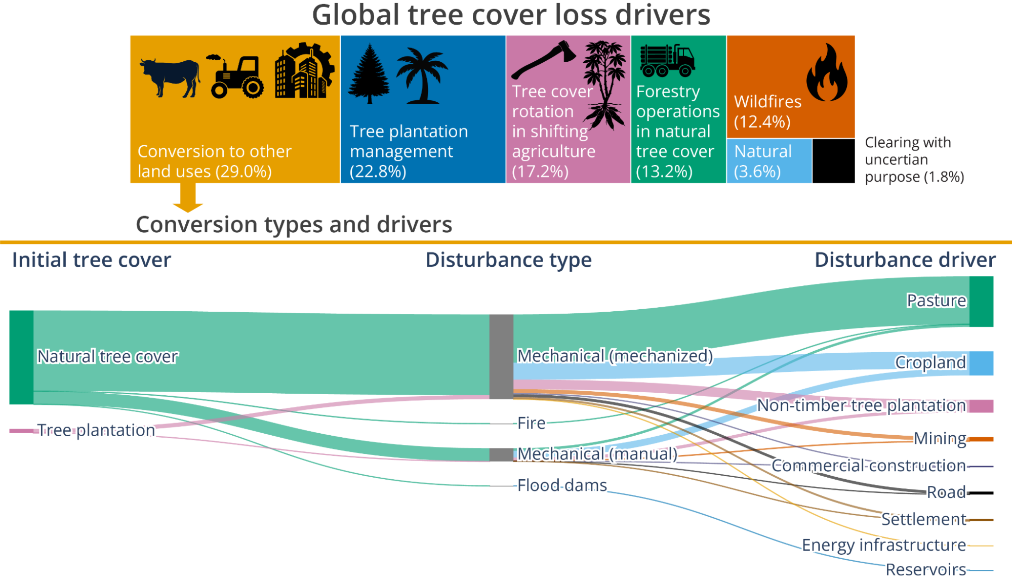
Infographic courtesy of Alexandra (Sasha)Tyukavina
The study found that agriculture was the primary force behind permanent tree cover loss. Expansion of cattle pasture, concentrated in Latin America, accounted for 15% of all global tree cover loss in 2018. Cropland expansion added another 6.4%, especially in dry woodlands across Africa and South America. Oil palm and rubber plantations represented a smaller share—3.8%—but remained significant drivers in Southeast Asia and West Africa.
The findings also suggest that available global maps of tree cover loss drivers may misidentify the causes of forest disturbances because of their aggregate spatial (1-10 km) and temporal (20+ years) scale. In some regions, existing maps classify temporary plantation harvesting cycles as permanent deforestation or fail to distinguish between shifting cultivation and long-term agricultural conversion.
“When maps get the drivers of tree cover loss wrong, it might shift the focus of deforestation efforts to the wrong regions,” said Tyukavina. “For example, we have seen a lot of areas in West Africa and Southeast Asia where oil palm and rubber plantations replaced natural tree cover well over 30 years ago, which are marked as new deforestation in the best available global tree cover loss drivers map.”
The researchers also found evidence of continuing degradation in some of the world’s most ecologically important forests. Roughly 17% of shifting agriculture-related tree cover loss in tropical regions expanded into primary forests rather than previously disturbed areas, particularly in the Democratic Republic of Congo and on the island of Borneo.
Mechanical clearing accounted for 84% of global tree cover loss in 2018, while fire was responsible for 12.4%. Natural disturbances such as insect outbreaks and hurricanes made up a smaller share, though researchers note that climate change could increase the importance of these factors in the future.
“As the climate and global economy shift, the drivers of forest loss will change. That’s why it is important to do follow-up assessments quantifying the trends in tree cover loss in the same statistically rigorous manner as the current study and utilizing the emerging high-resolution data sources,” Tyukavina said.
The research was supported by NASA’s Land Cover and Land Use Change program and Commercial SmallSat Data Acquisition Program, with additional support from the USGS/NASA Landsat Science Team, and conducted in collaboration with the World Resources Institute via Global Forest Watch and Land and Carbon Lab programs.
Paper: Tyukavina, A., Poulson, A. J., Pickering, J., Adusei, B., Hansen, M. C., Potapov, P., Baggett, A., Ortiz Dominguez, C., Mikus, A., ... Song, X.-P. (2026). Global extent and drivers of tree cover loss quantified with high-resolution satellite data. Science, 392(6802). https://doi.org/10.1126/science.adz9042
Image by Robert Jones from Pixabay
Published on Fri, 06/05/2026 - 14:42