UMD College of Behavorial & Social Sciences UMD College of Behavorial & Social Sciences
MENU

Topbar Menu

  • About Us
  • People
  • Alumni and Giving
  • Diversity
  • Undergraduate
    • Prospective Students
    • Courses & Facilities
    • Advising
    • Special Programs
    • Graduation
    • Geography Club
  • Graduate
    • Prospective Ph.D. Students
    • Graduate Courses
    • Graduate Student Publications
    • Graduate Student Awards
    • Graduate Students
    • Master of Science and Graduate Certificate Programs
    • Combined BS/MS Program
  • Research
    • Research Areas
      • Geospatial-Information Science and Remote Sensing
      • Human Dimensions of Global Change
      • Land Cover and Land Use Change
      • Carbon, Vegetation Dynamics and Landscape-Scale Processes
    • Centers
      • Center for Geospatial Information Science
      • International Center for Innovation in Geospatial Analytics & Earth Observation
  • High School Hub
    • Program Overview
    • High School Awards
    • High School Internship Program
    • GIS Day
  • Resources
    • Graduate Student Organization
    • Student Life
    • Graduate School
    • Responsible Conduct of Research
    • Emergency Preparedness
    • Job Opportunities
    • Graduation
Search

Main navigation

  • Undergraduate
    • Prospective Students
    • Courses & Facilities
    • Advising
    • Special Programs
    • Graduation
    • Geography Club
  • Graduate
    • Prospective Ph.D. Students
    • Graduate Courses
    • Graduate Student Publications
    • Graduate Student Awards
    • Graduate Students
    • Master of Science and Graduate Certificate Programs
    • Combined BS/MS Program
  • Research
    • Research Areas
      • Geospatial-Information Science and Remote Sensing
      • Human Dimensions of Global Change
      • Land Cover and Land Use Change
      • Carbon, Vegetation Dynamics and Landscape-Scale Processes
    • Centers
      • Center for Geospatial Information Science
      • International Center for Innovation in Geospatial Analytics & Earth Observation
  • High School Hub
    • Program Overview
    • High School Awards
    • High School Internship Program
    • GIS Day
  • Resources
    • Graduate Student Organization
    • Student Life
    • Graduate School
    • Responsible Conduct of Research
    • Emergency Preparedness
    • Job Opportunities
    • Graduation
  • About Us
  • People
  • Alumni and History
  • Diversity

Search our site:

UMD SKYCAM Project Deploys Sky Imagers in Antarctica

Breadcrumb

  • Home
  • Featured Content
  • UMD SKYCAM Project Deploys Sky Imagers In Antarctica
Series of 4 images of blue, cloudy Antarctic skies captured by SKYCAM at different times of day

Researchers from the Department of Geographical Sciences in collaboration with NASA Goddard Space Flight Center (GSFC) have deployed two sky imagers in Antarctica. This deployment is part of the SKYCAM project, led by Dr. Eric Vermote (NASA/GSFC, Emeritus Research Professor), aimed at establishing a global network of ground-based sky imagers for the study and characterization of clouds. 

“The SKYCAM project seeks to improve our understanding of clouds, their influence on remote sensing data, and to help enhance current cloud detection and characterization methods” says Dr. Andrés Santamaría-Artigas, a research scientist on the SKYCAM team. 

Clouds pose a major obstacle in optical remote sensing of the surface as they limit the number of useful observations made. Study of the data provided by SKYCAM will help address these challenges, as well as provide insights on cloud characterization with implications for global climate modeling, crop yield estimation, solar energy production and more. A proof-of-concept paper on utilizing sky imagery was published in 2021 in the International Journal of Applied Earth Observation and Geoinformation.

The SKYCAM field instruments, developed by UMD and NASA, take images at defined times and send them back to UMD for processing. Below is time-lapse footage from one of the sky imagers deployed at the Princess Elisabeth Station in Antarctica, in collaboration with the Royal Belgian Institute of Natural Sciences. 

{"preview_thumbnail":"/sites/geog.umd.edu/files/styles/video_embed_wysiwyg_preview/public/video_thumbnails/53wjrDJWOmw.jpg?itok=YmcS_uDn","video_url":"https://www.youtube.com/watch?v=53wjrDJWOmw","settings":{"responsive":1,"width":"854","height":"480","autoplay":0},"settings_summary":["Embedded Video (Responsive)."]}

Antarctic skies over Princess Elisabeth station. Courtesy of Quinten Vanhellemont (Royal Belgian Institute of Natural Sciences)

This deployment is of great interest to the project, as distinguishing between clouds and snow can be a significant challenge for remote sensing. Furthermore, it will allow testing of the instruments in one of the planet's most extreme environments.

The deployment of SKYCAM in Antarctica is the latest in a series of collaborations with national and international researchers and is part of the new International Center for Geospatial Innovation in the Department of Geographical Sciences. The SKYCAM team has already installed instruments at Goddard Space Flight Center (Maryland, USA), University of Valencia (Valencia, Spain), Sapienza University (Rome, Italy), and Sao Paulo University (Sao Paulo, Brazil). 

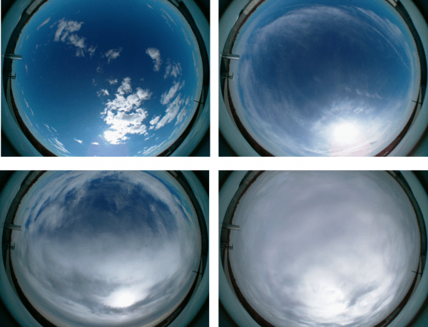
Image caption: Examples of SKYCAM imagery at Goddard Space Flight Center under different cloud cover conditions

Published on Thu, 01/27/2022 - 10:29

College of Behavorial & Social Sciences
  • Facebook
  • Twitter
  • Instagram
  • YouTube
  • LinkedIn
  • Zenfolio

Department of Geographical Sciences

2181 Samuel J. LeFrak Hall, 7251 Preinkert Drive,
University of Maryland, College Park, MD 20742
Phone: 301-405-4050

Join Our Newsletter

Contact Us

Links
  • UMD Land Acknowledgement
  • UMD Staff Directory
  • Give to GEOG
  • UMD Web Accessibility
  • Alumni
© 2025 College of Behavorial & Social Sciences. All Rights Reserved.
Login