UMD College of Behavorial & Social Sciences UMD College of Behavorial & Social Sciences
MENU

Topbar Menu

  • About Us
  • People
  • Alumni and Giving
  • Diversity
  • Undergraduate
    • Prospective Students
    • Courses & Facilities
    • Advising
    • Special Programs
    • Graduation
    • Geography Club
  • Graduate
    • Prospective Ph.D. Students
    • Graduate Courses
    • Graduate Student Publications
    • Graduate Student Awards
    • Graduate Students
    • Master of Science and Graduate Certificate Programs
    • Combined BS/MS Program
  • Research
    • Research Areas
      • Geospatial-Information Science and Remote Sensing
      • Human Dimensions of Global Change
      • Land Cover and Land Use Change
      • Carbon, Vegetation Dynamics and Landscape-Scale Processes
    • Centers
      • Center for Geospatial Information Science
      • International Center for Innovation in Geospatial Analytics & Earth Observation
  • High School Hub
    • Program Overview
    • High School Awards
    • High School Internship Program
    • GIS Day
  • Resources
    • Graduate Student Organization
    • Student Life
    • Graduate School
    • Responsible Conduct of Research
    • Emergency Preparedness
    • Job Opportunities
    • Graduation
Search

Main navigation

  • Undergraduate
    • Prospective Students
    • Courses & Facilities
    • Advising
    • Special Programs
    • Graduation
    • Geography Club
  • Graduate
    • Prospective Ph.D. Students
    • Graduate Courses
    • Graduate Student Publications
    • Graduate Student Awards
    • Graduate Students
    • Master of Science and Graduate Certificate Programs
    • Combined BS/MS Program
  • Research
    • Research Areas
      • Geospatial-Information Science and Remote Sensing
      • Human Dimensions of Global Change
      • Land Cover and Land Use Change
      • Carbon, Vegetation Dynamics and Landscape-Scale Processes
    • Centers
      • Center for Geospatial Information Science
      • International Center for Innovation in Geospatial Analytics & Earth Observation
  • High School Hub
    • Program Overview
    • High School Awards
    • High School Internship Program
    • GIS Day
  • Resources
    • Graduate Student Organization
    • Student Life
    • Graduate School
    • Responsible Conduct of Research
    • Emergency Preparedness
    • Job Opportunities
    • Graduation
  • About Us
  • People
  • Alumni and History
  • Diversity

Search our site:

UMD Satellite Data: Primary Source to Monitor Deforestation

Breadcrumb

  • Home
  • Featured Content
  • UMD Satellite Data: Primary Source To Monitor Deforestation
Primary tree loss in Brazil, Congo and Indonesia. Source: Global Forest Watch in The Economist

Satellite data analyzed by the Global Land Analysis and Discovery (GLAD) laboratory in the Department of Geographical Sciences has revealed insights into ongoing primary forest loss in Brazil, Indonesia and Democratic Republic of the Congo (DRC).

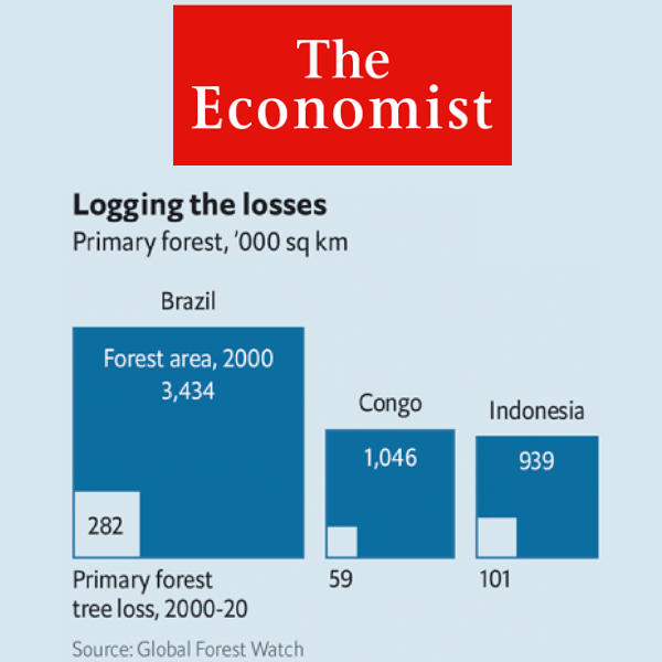
According to GLAD satellite data, Brazil tops the list for most primary forest loss, having lost 28.2Mha of humid primary forest or 45% of its total tree cover loss between 2001 and 2021. Indonesia lost 10.1Mha of humid primary forest, making up 35% of its total tree cover loss during the same period. And.DRC lost 49.5kha of tree cover, equivalent to 11% decrease in tree cover since 2000.

The GLAD findings, which were recently featured in The Economist, highlight the need for urgent action to curb deforestation and protect the world’s major rainforests. The rainforests in Brazil, Indonesia and DRC are giant absorbers of carbon dioxide, making them crucial players in the fight against climate change.

The main drivers of deforestation are ranching, commodity crop production and slash-and-burn agriculture. Millions of people rely on the rainforests for their livelihoods. Despite signing international pacts to curb deforestation, the three countries have struggled to enforce these agreements. Weak rule of law and the elite’s unwillingness to protect the forests are major obstacles, reports The Economist.

Since 2000, GLAD has monitored global forest extent and change as a part of the Global Forest Watch initiative in collaboration with the World Resources Institute (WRI). The Global Forest Watch is an online platform that provides data and tools for monitoring forests.

Matthew Hansen, GLAD co-director
Dr. Matthew Hansen

“The GLAD lab seeks to make timely and accurate maps of our changing planet that can inform how we may balance the maintenance of natural systems with economic development.,” says Dr. Matthew Hansen, GLAD’s co-director. “To date, nature is losing and the outcomes in the form of climate change, habitat loss and other impacts threaten the entire Earth system and our place in it.”

GLAD s is at the forefront of tracking changes in land cover and forest loss worldwide, serving as a primary data source for journalists, governments and nongovernmental organizations. GLAD satellite data is the only regularly updated, high-resolution map of forest change.

Led by Drs. Hansen and Peter Potapov, GLAD has worked with more than 20 countries and partnered with NASA, USAID and others to generate new science insights concerning land resources and changes. See all the lab’s projects here.

GLAD’s global forest monitoring, including interactive maps, is available freely to the public on its website. 

By Renata Johnson

Published on Thu, 03/30/2023 - 09:22

College of Behavorial & Social Sciences
  • Facebook
  • Twitter
  • Instagram
  • YouTube
  • LinkedIn
  • Zenfolio

Department of Geographical Sciences

2181 Samuel J. LeFrak Hall, 7251 Preinkert Drive,
University of Maryland, College Park, MD 20742
Phone: 301-405-4050

Join Our Newsletter

Contact Us

Links
  • UMD Land Acknowledgement
  • UMD Staff Directory
  • Give to GEOG
  • UMD Web Accessibility
  • Alumni
© 2025 College of Behavorial & Social Sciences. All Rights Reserved.
Login