UMD College of Behavorial & Social Sciences UMD College of Behavorial & Social Sciences
MENU

Topbar Menu

  • About Us
  • People
  • Alumni and Giving
  • Diversity
  • Undergraduate
    • Prospective Students
    • Courses & Facilities
    • Advising
    • Special Programs
    • Graduation
    • Geography Club
  • Graduate
    • Prospective Ph.D. Students
    • Graduate Courses
    • Graduate Student Publications
    • Graduate Student Awards
    • Graduate Students
    • Master of Science and Graduate Certificate Programs
    • Combined BS/MS Program
  • Research
    • Research Areas
      • Geospatial-Information Science and Remote Sensing
      • Human Dimensions of Global Change
      • Land Cover and Land Use Change
      • Carbon, Vegetation Dynamics and Landscape-Scale Processes
    • Centers
      • Center for Geospatial Information Science
      • International Center for Innovation in Geospatial Analytics & Earth Observation
  • High School Hub
    • Program Overview
    • High School Awards
    • High School Internship Program
    • GIS Day
  • Resources
    • Graduate Student Organization
    • Student Life
    • Graduate School
    • Responsible Conduct of Research
    • Emergency Preparedness
    • Job Opportunities
    • Graduation
Search

Main navigation

  • Undergraduate
    • Prospective Students
    • Courses & Facilities
    • Advising
    • Special Programs
    • Graduation
    • Geography Club
  • Graduate
    • Prospective Ph.D. Students
    • Graduate Courses
    • Graduate Student Publications
    • Graduate Student Awards
    • Graduate Students
    • Master of Science and Graduate Certificate Programs
    • Combined BS/MS Program
  • Research
    • Research Areas
      • Geospatial-Information Science and Remote Sensing
      • Human Dimensions of Global Change
      • Land Cover and Land Use Change
      • Carbon, Vegetation Dynamics and Landscape-Scale Processes
    • Centers
      • Center for Geospatial Information Science
      • International Center for Innovation in Geospatial Analytics & Earth Observation
  • High School Hub
    • Program Overview
    • High School Awards
    • High School Internship Program
    • GIS Day
  • Resources
    • Graduate Student Organization
    • Student Life
    • Graduate School
    • Responsible Conduct of Research
    • Emergency Preparedness
    • Job Opportunities
    • Graduation
  • About Us
  • People
  • Alumni and History
  • Diversity

Search our site:

UMD Researchers Use Space Laser Technology to Explain Dry Season Growth in Amazon Rainforest

Breadcrumb

  • Home
  • Featured Content
  • UMD Researchers Use Space Laser Technology To Explain Dry Season Growth In Amazon Rainforest
Amazon Manaus Forest

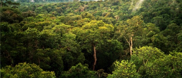
COLLEGE PARK, Md.—For more than a decade, scientists have debated what’s known as the “green up” phenomenon in the Amazon rainforest—when vegetation appears to thrive and grow fuller during the dry season with little or no rainfall. While some researchers have supported hypotheses that drought-induced growth does occur in the Amazon, others have argued it is more likely an optical illusion created by shadows cast from satellite positioning.

New research from the University of Maryland Department of Geographical Sciences published in the Proceedings of the National Academies of Sciences (PNAS) utilizes lidar satellite technology to more accurately measure seasonal changes in leaf area within the Amazon. Research Associate Hao Tang and Professor Ralph Dubayah analyzed data sets collected from NASA’s Geoscience Laser Altimeter System (GLAS) and found strong evidence of green up during the dry season in both the tree canopy and the underbrush; just not at the same time.

“Trees in the Amazon forests not only respond to seasonal environmental changes, but also have active ecological interactions as a community,” Tang said. “Tall trees grow leaves at the early dry season when both water and light are abundant; they then drop leaves during the mid-to-late dry season, not only protecting themselves from drought but also helping understory and small trees grow.”

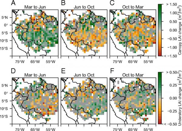
“This pattern is easily missed if you average over the entire Amazon basin because it progresses, almost like a wave, from south to north, with the dry season,” Dubayah added. “There is a plausible, ecological explanation for this: Light is driving the growth of the canopy in the early dry season and light from small gaps in the canopy that form later in the dry season drive the growth of the small shrubs and trees near the forest floor.”

The UMD researchers stress the need for better lidar observations of the Amazon’s canopy structure from space in order to more fully understand how rainforests respond to environmental and climate changes. Dubayah leads UMD’s Global Ecosystem Dynamics Investigation (GEDI), a NASA-funded mission to place a multi-beam laser instrument on the International Space Station in late 2018.

“The GEDI mission is optimized precisely to make these kinds of difficult measurements possible. It will provide more than 15 billion cloud-free observations during its 18-month mission and should greatly enhance our ability to understand canopy dynamics in the Amazon and elsewhere,” Dubayah said. 


Published on Thu, 02/23/2017 - 09:40

College of Behavorial & Social Sciences
  • Facebook
  • Twitter
  • Instagram
  • YouTube
  • LinkedIn
  • Zenfolio

Department of Geographical Sciences

2181 Samuel J. LeFrak Hall, 7251 Preinkert Drive,
University of Maryland, College Park, MD 20742
Phone: 301-405-4050

Join Our Newsletter

Contact Us

Links
  • UMD Land Acknowledgement
  • UMD Staff Directory
  • Give to GEOG
  • UMD Web Accessibility
  • Alumni
© 2025 College of Behavorial & Social Sciences. All Rights Reserved.
Login