UMD College of Behavorial & Social Sciences UMD College of Behavorial & Social Sciences
MENU

Topbar Menu

  • About Us
  • People
  • Alumni and Giving
  • Undergraduate
    • Prospective Students
    • Courses & Facilities
    • Advising
    • Special Programs
    • Graduation
    • Geography Club
  • Graduate
    • Prospective Ph.D. Students
    • Graduate Courses
    • Graduate Student Publications
    • Graduate Student Awards
    • Graduate Students
    • Master of Science and Graduate Certificate Programs
    • Combined BS/MS Program
  • Research
    • Research Areas
      • Geospatial-Information Science and Remote Sensing
      • Human Dimensions of Global Change
      • Land Cover and Land Use Change
      • Carbon, Vegetation Dynamics and Landscape-Scale Processes
    • Centers
      • Center for Geospatial Information Science
      • International Center for Innovation in Geospatial Analytics & Earth Observation
  • High School Hub
    • Program Overview
    • High School Awards
    • High School Internship Program
    • GIS Day
    • Request a Geographer
  • Resources
    • Graduate Student Organization
    • Student Life
    • Graduate School
    • Responsible Conduct of Research
    • Emergency Preparedness
    • Job Opportunities
    • Graduation
Search

Main navigation

  • Undergraduate
    • Prospective Students
    • Courses & Facilities
    • Advising
    • Special Programs
    • Graduation
    • Geography Club
  • Graduate
    • Prospective Ph.D. Students
    • Graduate Courses
    • Graduate Student Publications
    • Graduate Student Awards
    • Graduate Students
    • Master of Science and Graduate Certificate Programs
    • Combined BS/MS Program
  • Research
    • Research Areas
      • Geospatial-Information Science and Remote Sensing
      • Human Dimensions of Global Change
      • Land Cover and Land Use Change
      • Carbon, Vegetation Dynamics and Landscape-Scale Processes
    • Centers
      • Center for Geospatial Information Science
      • International Center for Innovation in Geospatial Analytics & Earth Observation
  • High School Hub
    • Program Overview
    • High School Awards
    • High School Internship Program
    • GIS Day
    • Request a Geographer
  • Resources
    • Graduate Student Organization
    • Student Life
    • Graduate School
    • Responsible Conduct of Research
    • Emergency Preparedness
    • Job Opportunities
    • Graduation
  • About Us
  • People
  • Alumni and History
  • Diversity

Search our site:

UMD Researchers Advance Wildfire Management at NASA FireSense Workshop in Alabama

Breadcrumb

  • Home
  • Featured Content
  • UMD Researchers Advance Wildfire Management At NASA FireSense Workshop In Alabama
A rear view of a white Ford pickup truck belonging to the Alabama Forestry Commission, parked in a lot under a bright sun. The tailgate features a graphic wrap of a wildfire at sunset with the silhouettes of two firefighters and the text, "Protecting Alabama’s forests from Wildfire." Mounted in the truck bed is a large red fire hose reel and specialized firefighting equipment. Similar agency vehicles are visible on either side, and the background shows a building tucked behind lush green trees.

Workshop brings together agencies and researchers to improve operational use of Earth observations

Associate research professor Joanne Hall, also NASA Wildland Fires Program associate program manager, and principal faculty specialist Rob Sohlberg, a FireSense science engagement analyst, joined a NASA FireSense stakeholder workshop April 23–24 at Auburn University’s Solon Dixon Forestry Education Center near Andalusia, Alabama, supporting the use of Earth observation data and NASA technologies in real-world wildfire management.

The workshop was organized in collaboration with the Alabama Forestry Commission (AFC), the University of Alabama at Huntsville (UAH), and the Alabama State Climatologist. It brought together federal and state agencies, the Tall Timbers land conservancy, and academic research partners to strengthen connections between Earth observation science, NASA technology, and operational wildland fire management.

The event convened approximately 40 in-person participants and 20 virtual attendees. Participants also included AFC commissioners, the Alabama Office of the State Climatologist, South Alabama Mesonet, and the Desert Research Institute, along with several academic institutions. Discussions focused on key operational challenges, gaps in current capabilities, and opportunities to improve decision-support tools for wildfire and prescribed fire management.

A three-image collage documenting a forestry workshop in Alabama. The top-left photo shows a group of people gathered outside the Solon Dixon Forestry Education Center, engaged in a discussion near a porch. The bottom-left image shows a person driving a utility vehicle down a dusty dirt path through a dense pine forest. The large photo on the right provides a close-up of an instructor in a tan shirt guiding a woman seated in the operator’s cabin of a yellow John Deere 450J bulldozer.

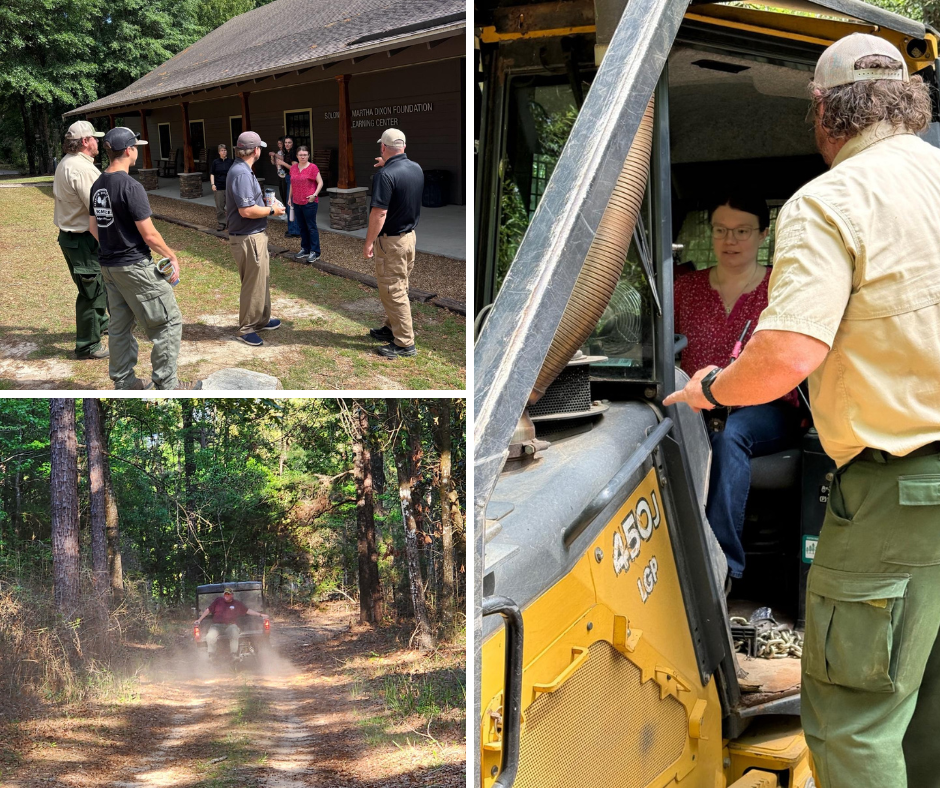
From top left, clockwise: Associate Research Professor Joanne Hall prepares to head into the field with FireSense colleagues and fire behavior analyst Ethan Barrett of the AFC; Hall receives bulldozer operator instruction from AFC forester Jason Berry during an impromptu firebreak test; and FireSense science engagement analyst Rob Sohlberg takes part in field activities across the 5,400-acre Solon Dixon managed forest, a diverse ecosystem dominated by longleaf pine.

Hall and Sohlberg played an active role in both technical discussions and hands-on engagement. Hall shared expertise on satellite-based fire monitoring and led a tutorial on NASA’s Fire Information for Resource Management System (FIRMS). She demonstrated how near real-time satellite data can support situational awareness for fire managers. Sohlberg participated in the workshop, supporting engagement around NASA fire products and their appropriate application in operational contexts.

The workshop built on an ongoing collaboration between NASA FireSense and the AFC, including recent joint field activities conducted in Geneva State Forest. Participants reviewed results from the 2025 field campaign and discussed next steps for integrating airborne and satellite observations into operational workflows. They also saw demonstrations of field-based tools such as UAS ignition systems, meteorological sensors, and heavy equipment operations.

“Direct engagement with fire managers is essential. It helps us understand their needs and ensure the tools we develop are both scientifically robust and operationally relevant,” Hall said.

FireSense is currently co-developing a hardened sensor package for trial on AFC bulldozers. These capabilities will improve situational awareness for the tractor driver, safeguard equipment, and contribute toward firefighter safety.

Images courtesy of Rob Sohlberg and Joanne Hall

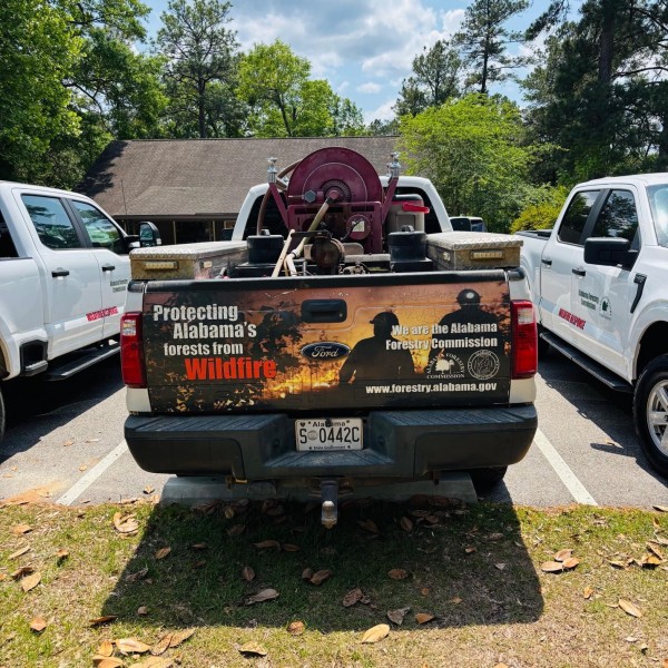
Main image: An Alabama Forestry Commission brush truck, equipped with a specialized hose reel, stands ready as firefighters from across the state gather for the NASA FireSense workshop April 23–24 at Auburn University’s Solon Dixon Forestry Education Center near Andalusia, Alabama.

Published on Fri, 05/01/2026 - 09:24

College of Behavioral & Social Sciences
  • Facebook
  • Twitter
  • Instagram
  • YouTube
  • LinkedIn
  • Zenfolio

Department of Geographical Sciences

2181 Samuel J. LeFrak Hall, 7251 Preinkert Drive,
University of Maryland, College Park, MD 20742
Phone: 301-405-4050

Subscribe to Our Newsletter

Contact Us

Links
  • UMD Land Acknowledgement
  • UMD Staff Directory
  • Give to GEOG
  • UMD Web Accessibility
  • Alumni
© 2026 College of Behavioral & Social Sciences. All Rights Reserved.
Login