UMD College of Behavorial & Social Sciences UMD College of Behavorial & Social Sciences
MENU

Topbar Menu

  • About Us
  • People
  • Alumni and Giving
  • Diversity
  • Undergraduate
    • Prospective Students
    • Courses & Facilities
    • Advising
    • Special Programs
    • Graduation
    • Geography Club
  • Graduate
    • Prospective Ph.D. Students
    • Graduate Courses
    • Graduate Student Publications
    • Graduate Student Awards
    • Graduate Students
    • Master of Science and Graduate Certificate Programs
    • Combined BS/MS Program
  • Research
    • Research Areas
      • Geospatial-Information Science and Remote Sensing
      • Human Dimensions of Global Change
      • Land Cover and Land Use Change
      • Carbon, Vegetation Dynamics and Landscape-Scale Processes
    • Centers
      • Center for Geospatial Information Science
      • International Center for Innovation in Geospatial Analytics & Earth Observation
  • High School Hub
    • Program Overview
    • High School Awards
    • High School Internship Program
    • GIS Day
  • Resources
    • Graduate Student Organization
    • Student Life
    • Graduate School
    • Responsible Conduct of Research
    • Emergency Preparedness
    • Job Opportunities
    • Graduation
Search

Main navigation

  • Undergraduate
    • Prospective Students
    • Courses & Facilities
    • Advising
    • Special Programs
    • Graduation
    • Geography Club
  • Graduate
    • Prospective Ph.D. Students
    • Graduate Courses
    • Graduate Student Publications
    • Graduate Student Awards
    • Graduate Students
    • Master of Science and Graduate Certificate Programs
    • Combined BS/MS Program
  • Research
    • Research Areas
      • Geospatial-Information Science and Remote Sensing
      • Human Dimensions of Global Change
      • Land Cover and Land Use Change
      • Carbon, Vegetation Dynamics and Landscape-Scale Processes
    • Centers
      • Center for Geospatial Information Science
      • International Center for Innovation in Geospatial Analytics & Earth Observation
  • High School Hub
    • Program Overview
    • High School Awards
    • High School Internship Program
    • GIS Day
  • Resources
    • Graduate Student Organization
    • Student Life
    • Graduate School
    • Responsible Conduct of Research
    • Emergency Preparedness
    • Job Opportunities
    • Graduation
  • About Us
  • People
  • Alumni and History
  • Diversity

Search our site:

UMD Research Provides Comprehensive Monitoring of Forest Loss in Brazilian Amazon

Breadcrumb

  • Home
  • Featured Content
  • UMD Research Provides Comprehensive Monitoring of Forest Loss In Brazilian Amazon
*2000-2013 state-level tree cover loss area estimates*

College Park, Md.—New research led by the University of Maryland (UMD) Department of Geographical Sciences employs satellite image time series to better understand the dynamics of forest cover loss in the Brazilian Amazon. While rates of deforestation in the country have slowed significantly over the last decade, Brazil remains the single largest contributor to natural forest loss among tropical countries.

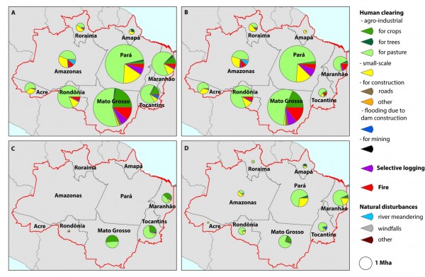
The study uses a statistical sample to produce unbiased (free from map errors) estimates of forest loss area in different types of forests: primary and secondary humid tropical forests; natural and secondary woodlands; and plantations. It also attributes the drivers of forest loss, such as conversion of forests to pastures and croplands, selective logging, mining and fires.
“Brazil’s current national forest monitoring system focuses almost solely on deforestation in primary forests —the process of forest clearing and conversion to nonforest land uses. However, that only tells us part of the story,” said Alexandra Tyukavina, a post-doctoral researcher with the UMD Department of Geographical Sciences. “Our research seeks to dig deeper into the dynamic causes of forest loss in all types of forests so that we can better understand the consequences such as carbon emissions and biodiversity losses.”

One of the major findings of the study is that by the year 2013, all other forest disturbance types surpassed deforestation in primary forests in area, but deforestation in primary forests still remained the major source of aboveground carbon loss. Results of this research were published in Science Advances on April 12.

Researchers are working to expand the current study into the other tropical regions, such as Central Africa and Indonesia, to provide a comprehensive story on forest loss drivers pan-tropically.
Members of the research team from the UMD Department of Geographical Sciences include Tyukavina, Matthew Hansen, Peter Potapov, Kevin Smith-Rodriguez, Chima Okpa and Ricardo Aguilar. Stephen Stehman from the Department of Forest and Natural Resource Management at the State University of New York also contributed.

Source: BSOS press release

Published on Wed, 04/12/2017 - 17:02

College of Behavorial & Social Sciences
  • Facebook
  • Twitter
  • Instagram
  • YouTube
  • LinkedIn
  • Zenfolio

Department of Geographical Sciences

2181 Samuel J. LeFrak Hall, 7251 Preinkert Drive,
University of Maryland, College Park, MD 20742
Phone: 301-405-4050

Join Our Newsletter

Contact Us

Links
  • UMD Land Acknowledgement
  • UMD Staff Directory
  • Give to GEOG
  • UMD Web Accessibility
  • Alumni
© 2025 College of Behavorial & Social Sciences. All Rights Reserved.
Login