
Tracking the Final Wilderness Frontiers
UMD researchers measure global loss of intact forest landscapes
COLLEGE PARK, Md.—Researchers from the University of Maryland utilize satellite imagery to demonstrate that forest wildlands—forests least affected by human activity—are steadily shrinking and pinpoint ways to help preserve these landscapes that are critically important to the health of the planet.
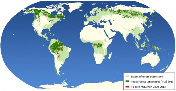
Led by Associate Professor Peter Potapov from the UMD Department of Geographical Sciences, the research team used Landsat satellite images from 2000 and 2013 to map intact forest landscapes (IFL) around the globe. Researchers defined IFLs as areas of forest and associated naturally treeless ecosystems spanning a minimum of 200 square miles with no remotely detected signs of human activity. They found that these forest wildlands decreased globally by 7.2% during this time period—amounting to nearly 355,000 square miles lost—primarily due to industrial logging, agricultural expansion, fire and mining/resource extraction. Their work is featured in a January 13th publication of Science Advances.
“Forest wildlands have an extremely high conservation value and are irreplaceable due to the range of ecosystem services they provide such as harboring biological diversity, stabilizing carbon storage and regulating water flow,” Potapov said. “Furthermore, the size of the wildland matters: the larger the size, the higher the conservation value. That’s why we need to be concerned about losing any portion of these precious forest landscapes.”
Not only did researchers discover an overall reduction in IFLs worldwide, they found that the rate of reduction is increasing: The loss of tropical forest wildland tripled between 2011 and 2013 when compared to the period between 2001 and 2003.
During their analysis, researchers discovered that areas of forest wildland designated as legally protected areas were less likely to suffer a reduction in size and advocate for the adoption of more national and international policies to preserve IFLs and their abundant contributions to the environment.
Co-author Dr. Matt Hansen, Professor of Geographical Sciences at UMD, emphasized the importance of intact forests, stating “The high carbon stocks found within forest wildlands alone illustrate their potential benefit to climate change mitigation strategies. However, their stability can be compromised very rapidly. For example, increased human access through road building reduces forest intactness even without the loss of many trees. Importantly, IFLs only shrink in extent as they are defined as landscapes absent of observable human impacts.”
Along with Potapov and Hansen, the research team included Research Associate Svetlana Turubanova from the UMD Department of Geographical Sciences and partners from organizations around the world, including: Laestadius Consulting in Silver Spring, MD; Greenpeace; Global Forest Watch Canada; World Resources Institute; and NGO Transparent World in Moscow, Russia.
Published on Fri, 01/13/2017 - 16:06