UMD College of Behavorial & Social Sciences UMD College of Behavorial & Social Sciences
MENU

Topbar Menu

  • About Us
  • People
  • Alumni and Giving
  • Diversity
  • Undergraduate
    • Prospective Students
    • Courses & Facilities
    • Advising
    • Special Programs
    • Graduation
    • Geography Club
  • Graduate
    • Prospective Ph.D. Students
    • Graduate Courses
    • Graduate Student Publications
    • Graduate Student Awards
    • Graduate Students
    • Master of Science and Graduate Certificate Programs
    • Combined BS/MS Program
  • Research
    • Research Areas
      • Geospatial-Information Science and Remote Sensing
      • Human Dimensions of Global Change
      • Land Cover and Land Use Change
      • Carbon, Vegetation Dynamics and Landscape-Scale Processes
    • Centers
      • Center for Geospatial Information Science
      • International Center for Innovation in Geospatial Analytics & Earth Observation
  • High School Hub
    • Program Overview
    • High School Awards
    • High School Internship Program
    • GIS Day
  • Resources
    • Graduate Student Organization
    • Student Life
    • Graduate School
    • Responsible Conduct of Research
    • Emergency Preparedness
    • Job Opportunities
    • Graduation
Search

Main navigation

  • Undergraduate
    • Prospective Students
    • Courses & Facilities
    • Advising
    • Special Programs
    • Graduation
    • Geography Club
  • Graduate
    • Prospective Ph.D. Students
    • Graduate Courses
    • Graduate Student Publications
    • Graduate Student Awards
    • Graduate Students
    • Master of Science and Graduate Certificate Programs
    • Combined BS/MS Program
  • Research
    • Research Areas
      • Geospatial-Information Science and Remote Sensing
      • Human Dimensions of Global Change
      • Land Cover and Land Use Change
      • Carbon, Vegetation Dynamics and Landscape-Scale Processes
    • Centers
      • Center for Geospatial Information Science
      • International Center for Innovation in Geospatial Analytics & Earth Observation
  • High School Hub
    • Program Overview
    • High School Awards
    • High School Internship Program
    • GIS Day
  • Resources
    • Graduate Student Organization
    • Student Life
    • Graduate School
    • Responsible Conduct of Research
    • Emergency Preparedness
    • Job Opportunities
    • Graduation
  • About Us
  • People
  • Alumni and History
  • Diversity

Search our site:

Supporting Malaria Elimination in Myanmar

Breadcrumb

  • Home
  • Featured Content
  • Supporting Malaria Elimination In Myanmar
Forecasting malaria load through the early warning system

A recent emergence of drug-resistant malaria parasites in the Greater Mekong region is posed to undermine the World Health Organization’s (WHO) inspiring agenda of global malaria elimination.  Tatiana Loboda (UMD Department of Geographical Sciences) and Mark Carroll (SSAI/NASA Goddard Space Flight Center) have received funding from NASA within the Group on Earth Observations Work Programme to develop a satellite data driven early warning system to support malaria elimination efforts in Myanmar. Myanmar, one of the 5 countries with documented cases of artemisinin resistant malaria, carries a disproportional malaria burden. Despite containing only ~4% of the Great Mekong region’s population, it bears 20% of the region’s malaria. 

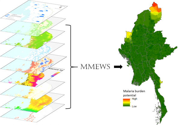
The highly multi-disciplinary team developing the early warning system involves experts in remote sensing, spatial analysis, and malariology, with the goal of supporting medical intervention activities.  Through previous and on-going research and intervention activities, members of the proposing team have established an extensive network and research base in Myanmar and are poised for a strong continuing engagement in malaria elimination work there. This funded project will support these efforts by developing a robust satellite data driven early warning system to forecast malaria hotspots dynamically in space and time.  Myanmar Malaria Early Warning System (MMEWS) will be designed to move the satellite-based malaria forecasting beyond the narrow scope of monitoring and forecasting mosquito habitat suitability and the potential for surges in mosquito prevalence. The Malaria Burden Potential – the primary system output in support of elimination and treatment activities – will present a combination of environmental factors that control mosquito populations and environmental, socio-economic, and political factors that control population exposure and vulnerability.  The proposed system will be deployed in the Yangon office of the Duke Global Health Institute in Myanmar and shared widely with regional partners and the public health community.

Published on Tue, 12/05/2017 - 09:40

College of Behavorial & Social Sciences
  • Facebook
  • Twitter
  • Instagram
  • YouTube
  • LinkedIn
  • Zenfolio

Department of Geographical Sciences

2181 Samuel J. LeFrak Hall, 7251 Preinkert Drive,
University of Maryland, College Park, MD 20742
Phone: 301-405-4050

Join Our Newsletter

Contact Us

Links
  • UMD Land Acknowledgement
  • UMD Staff Directory
  • Give to GEOG
  • UMD Web Accessibility
  • Alumni
© 2025 College of Behavorial & Social Sciences. All Rights Reserved.
Login