
Rachel Lamb Leads Paper on the Economic Potential of Reforestation in Maryland
Researchers in the Department of Geographical Sciences (GEOG) have long been innovating and harnessing advanced NASA Carbon Monitoring System (CMS) science to estimate forest carbon baselines, sequestration potentials and annual fluxes at high spatial resolutions. In partnership with the State of Maryland, this science has become increasingly operationalized in state policy and planning, including the 2030 Greenhouse Gas Reduction Act plan and the 2020 state greenhouse gas inventory.
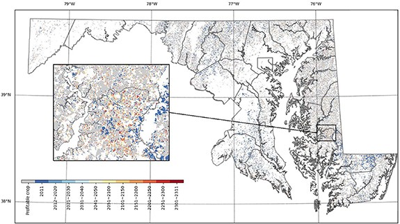
In a recent paper, led by Adjunct Assistant Professor Rachel Lamb, GEOG researchers rely upon but move one step beyond wall-to-wall estimates of forest carbon sequestration potentials to identify strategic reforestation opportunities in the State. By coupling NASA CMS high-resolution remote sensing and ecosystem modeling with novel economic analysis, Lamb et al. identify spatially explicit areas of economic opportunity where the potential revenue from forest carbon outcompetes the expected profit of existing cropland at the hectare scale. They find that under a baseline economic scenario of $20 per ton of carbon (5% rental rate) and decadal average crop profitability, a transition to forest on agricultural land would be more profitable than 23.2% of cropland in Maryland under a 20-year land-use commitment. Accounting for variations in carbon and crop pricing, 5.5%–55.4% of cropland would be immediately outcompeted by expected forest carbon revenue, with the potential for an additional 0.5%–10.6% of outcompeted cropland within 20 years.
Given the economic opportunity for farmers, the authors also considered the cost to fund such a program and the amount of carbon subsequently protected. For example, under the baseline scenario, an annual allocation of $5.8 million towards a carbon rental program could protect 6.93 Tg C (3.4% of the state's total remaining CSPG) on reforested croplands. This moderate yearly cost is equal to 9.7% of Maryland's average annual auction proceeds from participation in the Regional Greenhouse Gas Initiative (between 2014 and 2018), and 19.3% of the average annual subsidy payments for corn, soy, and wheat allocated over the same period.
While outcompeted lands under the baseline scenario represent a small fraction of the remaining CSP, 6.94 Tg C is 16 times the amount of carbon (1.5 MMtCO2e) expected to be sequestered by 2030 via state forest management and reforestation activities listed within the Greenhouse Gas Emissions Reduction Act plan.
This work was supported in part by NASA’s Carbon Monitoring System and co-authored by GEOG researchers, including Lei Ma, George Hurtt,Ritvik Sahajpal, Ralph Dubyah, and Ph.D. candidate Jennifer Kennedy, as well as Jae Edmonds and Nate Hultman from the Joint Global Change Research Institute and School of Public Policy.
Please see the links below to access this paper as well as the related papers on carbon sequestration mapping and modeling in Maryland:
Lamb et al. 2021 - Geospatial assessment of the economic opportunity for reforestation in Maryland, USA -https://iopscience.iop.org/article/10.1088/1748-9326/ac109a/meta
Hurtt et al. 2019 - Beyond MRV: high-resolution forest carbon modeling for climate mitigation planning over Maryland, USA - https://iopscience.iop.org/article/10.1088/1748-9326/ab0bbe
Huang et al. 2019 - High-resolution mapping of aboveground biomass for forest carbon monitoring system in the Tri-State region of Maryland, Pennsylvania, and Delaware, USA - https://iopscience.iop.org/article/10.1088/1748-9326/ab2917
Published on Tue, 09/21/2021 - 13:52