UMD College of Behavorial & Social Sciences UMD College of Behavorial & Social Sciences
MENU

Topbar Menu

  • About Us
  • People
  • Alumni and Giving
  • Diversity
  • Undergraduate
    • Prospective Students
    • Courses & Facilities
    • Advising
    • Special Programs
    • Graduation
    • Geography Club
  • Graduate
    • Prospective Ph.D. Students
    • Graduate Courses
    • Graduate Student Publications
    • Graduate Student Awards
    • Graduate Students
    • Master of Science and Graduate Certificate Programs
    • Combined BS/MS Program
  • Research
    • Research Areas
      • Geospatial-Information Science and Remote Sensing
      • Human Dimensions of Global Change
      • Land Cover and Land Use Change
      • Carbon, Vegetation Dynamics and Landscape-Scale Processes
    • Centers
      • Center for Geospatial Information Science
      • International Center for Innovation in Geospatial Analytics & Earth Observation
  • High School Hub
    • Program Overview
    • High School Awards
    • High School Internship Program
    • GIS Day
  • Resources
    • Graduate Student Organization
    • Student Life
    • Graduate School
    • Responsible Conduct of Research
    • Emergency Preparedness
    • Job Opportunities
    • Graduation
Search

Main navigation

  • Undergraduate
    • Prospective Students
    • Courses & Facilities
    • Advising
    • Special Programs
    • Graduation
    • Geography Club
  • Graduate
    • Prospective Ph.D. Students
    • Graduate Courses
    • Graduate Student Publications
    • Graduate Student Awards
    • Graduate Students
    • Master of Science and Graduate Certificate Programs
    • Combined BS/MS Program
  • Research
    • Research Areas
      • Geospatial-Information Science and Remote Sensing
      • Human Dimensions of Global Change
      • Land Cover and Land Use Change
      • Carbon, Vegetation Dynamics and Landscape-Scale Processes
    • Centers
      • Center for Geospatial Information Science
      • International Center for Innovation in Geospatial Analytics & Earth Observation
  • High School Hub
    • Program Overview
    • High School Awards
    • High School Internship Program
    • GIS Day
  • Resources
    • Graduate Student Organization
    • Student Life
    • Graduate School
    • Responsible Conduct of Research
    • Emergency Preparedness
    • Job Opportunities
    • Graduation
  • About Us
  • People
  • Alumni and History
  • Diversity

Search our site:

PhD Student Donal O'Leary Wins Outstanding Student Paper Award at AGU Fall Meeting

Breadcrumb

  • Home
  • Featured Content
  • PhD Student Donal O'Leary Wins Outstanding Student Paper Award At AGU Fall Meeting
Snowmelt timing

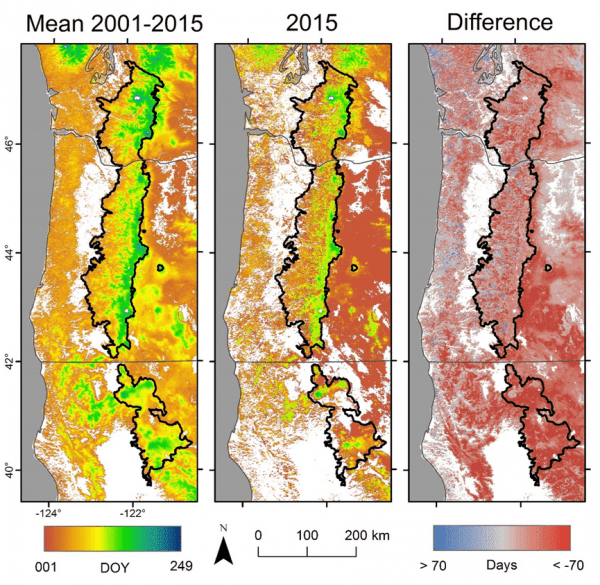
PhD student Donal O'Leary received the American Geophysical Union's (AGU) Outstanding Student Paper Award in the Cryosphere category for his paper titled "Investigating the early snowmelt of 2015 in the Cascade Mountains using new MODIS-based snowmelt timing maps." This award is earned by the top 2-5% of students who present research in geophysical sciences at the AGU Fall Meeting. In his talk, Donal and collaborators developed a method to extract new information from an established MODIS dataset, leading to discoveries about the severity and extent of the alarmingly early snowmelt of 2015 in the mountains of California, Oregon, and Washington State. Their dataset is hosted at the Oak Ridge National Laboratory repository and has been further employed in their recent article comparing snowmelt timing with plant phenology in Crate Lake National Park. The abstract for this article is provided below:

Anthropogenic climate change is having significant impacts on montane and high-elevation areas globally. Warmer winter temperatures are driving reduced snowpack in the western USA with broad potential impacts on ecosystem dynamics of particular concern for protected areas. Vegetation phenology is a sensitive indicator of ecological response to climate change and is associated with snowmelt timing. Human monitoring of climate impacts can be resource prohibitive for land management agencies, whereas remotely sensed phenology observations are freely available at a range of spatiotemporal scales. Little work has been done in regions dominated by evergreen conifer cover, which represents many mountain regions at temperate latitudes. We used moderate resolution imaging spectroradiometer (MODIS) data to assess the influence of snowmelt timing and elevation on five phenology metrics (green up, maximum greenness, senescence, dormancy, and growing season length) within Crater Lake National Park, Oregon, USA from 2001 to 2012. Earlier annual mean snowmelt timing was significantly correlated with earlier onset of green up at the landscape scale. Snowmelt timing and elevation have significant explanatory power for phenology, though with high variability. Elevation has a moderate control on early season indicators such as snowmelt timing and green up and less on late-season variables such as senescence and growing season length. PCA results show that early season indicators and late season indicators vary independently. These results have important implications for ecosystem dynamics, management, and conservation, particularly of species such as whitebark pine (Pinus albicaulis) in alpine and subalpine areas.

More information about the award can be found here.

Congratulations Donal!


Published on Thu, 02/01/2018 - 10:48

College of Behavorial & Social Sciences
  • Facebook
  • Twitter
  • Instagram
  • YouTube
  • LinkedIn
  • Zenfolio

Department of Geographical Sciences

2181 Samuel J. LeFrak Hall, 7251 Preinkert Drive,
University of Maryland, College Park, MD 20742
Phone: 301-405-4050

Join Our Newsletter

Contact Us

Links
  • UMD Land Acknowledgement
  • UMD Staff Directory
  • Give to GEOG
  • UMD Web Accessibility
  • Alumni
© 2025 College of Behavorial & Social Sciences. All Rights Reserved.
Login