UMD College of Behavorial & Social Sciences UMD College of Behavorial & Social Sciences
MENU

Topbar Menu

  • About Us
  • People
  • Alumni and Giving
  • Diversity
  • Undergraduate
    • Prospective Students
    • Courses & Facilities
    • Advising
    • Special Programs
    • Graduation
    • Geography Club
  • Graduate
    • Prospective Ph.D. Students
    • Graduate Courses
    • Graduate Student Publications
    • Graduate Student Awards
    • Graduate Students
    • Master of Science and Graduate Certificate Programs
    • Combined BS/MS Program
  • Research
    • Research Areas
      • Geospatial-Information Science and Remote Sensing
      • Human Dimensions of Global Change
      • Land Cover and Land Use Change
      • Carbon, Vegetation Dynamics and Landscape-Scale Processes
    • Centers
      • Center for Geospatial Information Science
      • International Center for Innovation in Geospatial Analytics & Earth Observation
  • High School Hub
    • Program Overview
    • High School Awards
    • High School Internship Program
    • GIS Day
  • Resources
    • Graduate Student Organization
    • Student Life
    • Graduate School
    • Responsible Conduct of Research
    • Emergency Preparedness
    • Job Opportunities
    • Graduation
Search

Main navigation

  • Undergraduate
    • Prospective Students
    • Courses & Facilities
    • Advising
    • Special Programs
    • Graduation
    • Geography Club
  • Graduate
    • Prospective Ph.D. Students
    • Graduate Courses
    • Graduate Student Publications
    • Graduate Student Awards
    • Graduate Students
    • Master of Science and Graduate Certificate Programs
    • Combined BS/MS Program
  • Research
    • Research Areas
      • Geospatial-Information Science and Remote Sensing
      • Human Dimensions of Global Change
      • Land Cover and Land Use Change
      • Carbon, Vegetation Dynamics and Landscape-Scale Processes
    • Centers
      • Center for Geospatial Information Science
      • International Center for Innovation in Geospatial Analytics & Earth Observation
  • High School Hub
    • Program Overview
    • High School Awards
    • High School Internship Program
    • GIS Day
  • Resources
    • Graduate Student Organization
    • Student Life
    • Graduate School
    • Responsible Conduct of Research
    • Emergency Preparedness
    • Job Opportunities
    • Graduation
  • About Us
  • People
  • Alumni and History
  • Diversity

Search our site:

New Map Shows Decreasing Forest Heights in Europe in Past Two Decades

Breadcrumb

  • Home
  • Featured Content
  • New Map Shows Decreasing Forest Heights In Europe In Past Two Decades
Europe tree cover
A new study led by the Global Land Analysis and Discovery team's Assistant Research Scientist Svetlana Turubanova was just published in Remote Sensing of Environment.
 
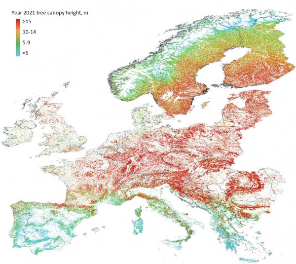
The study provides a comprehensive dataset characterizing annual changes in tree canopy cover across the Europe from 2001 to 2021. The changes in tree canopy cover are modeled using the multidecadal spectral data from the Landsat archive and calibration data from Airborne Laser Scanning (ALS) and spaceborne Global Ecosystem Dynamics Investigation (GEDI) lidars.
 
An interactive web app allows to view and download the map.
 
Analysis of the resulting map revealed that the European tree canopy extent area increased by nearly 1% overall during the past two decades, with the largest increase observed in Eastern Europe, Southern Europe and the British Isles. However, after 2016, the tree canopy extent in Europe declined. Some regions reduced their tree canopy extent between 2001 and 2021, with the highest reduction observed in Fennoscandia (3.5% net decrease). The continental extent of tall tree canopy forests (≥ 15 m height) decreased by 3% from 2001 to 2021.
 
The recent decline in tree canopy extent agrees with the FAO statistics on timber harvesting intensification and with the increasing extent and severity of natural disturbances. The observed decreasing tree canopy height indicates a reduction in forest carbon storage capacity in Europe.
 
Image:The year 2021 tree canopy height (~30 meters per pixel spatial resolution data). Available here.
 

Published on Mon, 09/11/2023 - 11:16

College of Behavorial & Social Sciences
  • Facebook
  • Twitter
  • Instagram
  • YouTube
  • LinkedIn
  • Zenfolio

Department of Geographical Sciences

2181 Samuel J. LeFrak Hall, 7251 Preinkert Drive,
University of Maryland, College Park, MD 20742
Phone: 301-405-4050

Join Our Newsletter

Contact Us

Links
  • UMD Land Acknowledgement
  • UMD Staff Directory
  • Give to GEOG
  • UMD Web Accessibility
  • Alumni
© 2025 College of Behavorial & Social Sciences. All Rights Reserved.
Login