
New GLAD-Led Research Shows 6% Increase in Global Cropland Area Over the Last Decade
Machine-learning approach delivers a sharper global view of cropland change.
A new study from UMD's Global Land Analysis and Discovery (GLAD) team at the University of Maryland finds that global cropland expanded by more than 6% between 2015 and 2024, even as population continues to outpace gains in agricultural land.
Published in Remote Sensing of Environment, the study uses a machine-learning approach and nearly a decade of Landsat Analysis Ready Data to map the annual cropland extent worldwide at 30-meter resolution. Combined with earlier findings from Potapov et al. (2022) in Nature Food, the results show cumulative expansion reaching nearly 14% since 2003.
The analysis reveals stark regional differences. Africa saw the largest increase by adding 24.5 million hectares of cropland. Brazil led all countries with a gain of 16.5 million hectares, while Morocco recorded the largest national decline, losing 0.38 million hectares amid prolonged drought. About one-third of new cropland (33.3%) came from clearing natural vegetation or expanding irrigation into natural drylands.
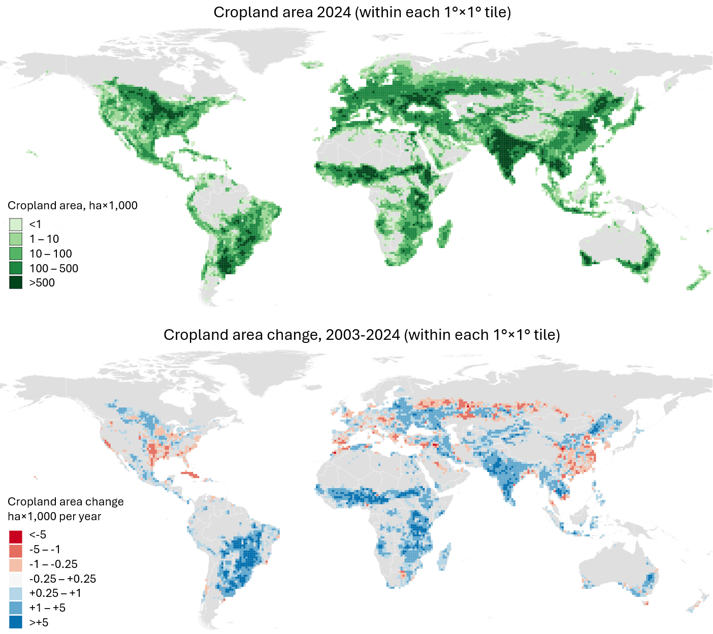
Despite this growth, cropland per person is shrinking. Per-capita cropland declined from 0.166 to 0.161 hectares per person between 2015 and 2024, underscoring increasing pressure on global food systems as climate change, conflicts and shifting diets drive demand.
The team also developed a globally consistent system for annual cropland mapping using GLAD Landsat Analysis Ready Data (ARD). The maps achieved 97.8% overall accuracy in 2015 and 97.3% in 2024, demonstrating strong reliability. With the ability to update annually, the system can support food-security early warning, inform agricultural policy and help track progress toward the UN Sustainable Development Goals.
“This study marks a major step forward in global agricultural monitoring,” said Ahmad Khan, assistant research professor in the Department of Geographical Sciences and lead author of the paper. “The world faces a tightening balance between food production and environmental sustainability. The new Landsat-based system offers a powerful tool to navigate that challenge with clearer, more timely information.”
Paper: Khan, A., Potapov, P., Turubanova, S., Hansen, M. C., Tyukavina, A., Poulson, A., Hernandez-Serna, A., Song, X.-P., Harris, N., & Stolle, F. (2026). Global annual cropland dynamics 2015–2024. Remote Sensing of Environment, 340, 115438. https://doi.org/10.1016/j.rse.2026.115438
Published on Tue, 04/28/2026 - 09:51