UMD College of Behavorial & Social Sciences UMD College of Behavorial & Social Sciences
MENU

Topbar Menu

  • About Us
  • People
  • Alumni and Giving
  • Diversity
  • Undergraduate
    • Prospective Students
    • Courses & Facilities
    • Advising
    • Special Programs
    • Graduation
    • Geography Club
  • Graduate
    • Prospective Ph.D. Students
    • Graduate Courses
    • Graduate Student Publications
    • Graduate Student Awards
    • Graduate Students
    • Master of Science and Graduate Certificate Programs
    • Combined BS/MS Program
  • Research
    • Research Areas
      • Geospatial-Information Science and Remote Sensing
      • Human Dimensions of Global Change
      • Land Cover and Land Use Change
      • Carbon, Vegetation Dynamics and Landscape-Scale Processes
    • Centers
      • Center for Geospatial Information Science
      • International Center for Innovation in Geospatial Analytics & Earth Observation
  • High School Hub
    • Program Overview
    • High School Awards
    • High School Internship Program
    • GIS Day
  • Resources
    • Graduate Student Organization
    • Student Life
    • Graduate School
    • Responsible Conduct of Research
    • Emergency Preparedness
    • Job Opportunities
    • Graduation
Search

Main navigation

  • Undergraduate
    • Prospective Students
    • Courses & Facilities
    • Advising
    • Special Programs
    • Graduation
    • Geography Club
  • Graduate
    • Prospective Ph.D. Students
    • Graduate Courses
    • Graduate Student Publications
    • Graduate Student Awards
    • Graduate Students
    • Master of Science and Graduate Certificate Programs
    • Combined BS/MS Program
  • Research
    • Research Areas
      • Geospatial-Information Science and Remote Sensing
      • Human Dimensions of Global Change
      • Land Cover and Land Use Change
      • Carbon, Vegetation Dynamics and Landscape-Scale Processes
    • Centers
      • Center for Geospatial Information Science
      • International Center for Innovation in Geospatial Analytics & Earth Observation
  • High School Hub
    • Program Overview
    • High School Awards
    • High School Internship Program
    • GIS Day
  • Resources
    • Graduate Student Organization
    • Student Life
    • Graduate School
    • Responsible Conduct of Research
    • Emergency Preparedness
    • Job Opportunities
    • Graduation
  • About Us
  • People
  • Alumni and History
  • Diversity

Search our site:

NASA Harvest at South by Southwest: Understanding Food Insecurity from Space

Breadcrumb

  • Home
  • Featured Content
  • NASA Harvest At South By Southwest: Understanding Food Insecurity From Space
Panel at South by Southwest

How do NASA data and tools help farmers decide when and how much to water their crops? Can humanitarian agencies predict where drought or war will hit hardest?

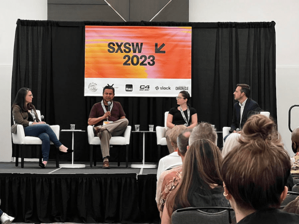
Mary Mitkish, the assistant program manager and communications lead for NASA Harvest, tackled these and other questions on “Tackling Food Insecurity with NASA Satellite Data” at South by Southwest in Austin Texas in March. 

With a passion for using technology to help solve real-world problems, Mitkish shared insights into how NASA satellite data is transforming the way we grow food and making a massive impact on farmers worldwide.

“We are able to compare what’s happening today to what we know to be the averages over time,” said Miktish. “That enables us to flag areas of concern.”

During the discussion, Mitkish and fellow experts delved into how NASA's data and tools are empowering farmers to make informed decisions regarding crop irrigation, as well as providing critical insights for humanitarian organizations to address unexpected conditions. 

With food insecurity becoming an increasingly pressing issue on a global scale, the use of advanced technology and data-driven solutions has become more crucial than ever. 

The NASA Harvest Consortium, led by UMD researchers, brings together partners from different sectors. Besides creating tools and Earth observation-based products, the team also provides training sessions for end-users who are not remote-sensing experts. 

In the next five years, Mitkish hopes to scale the Earth observation-based tools and further develop strong partnerships.

“The ultimate goal is to ensure that anyone who is looking for better information can access it,” she said in an interview for NASA Applied Sciences.

Listen to the panel on SXSW
Read Miktish’s interview on NASA Applied Sciences

Photo courtesy of Jessi Cape, the Austin Chronicle

Published on Thu, 04/20/2023 - 17:54

College of Behavorial & Social Sciences
  • Facebook
  • Twitter
  • Instagram
  • YouTube
  • LinkedIn
  • Zenfolio

Department of Geographical Sciences

2181 Samuel J. LeFrak Hall, 7251 Preinkert Drive,
University of Maryland, College Park, MD 20742
Phone: 301-405-4050

Join Our Newsletter

Contact Us

Links
  • UMD Land Acknowledgement
  • UMD Staff Directory
  • Give to GEOG
  • UMD Web Accessibility
  • Alumni
© 2025 College of Behavorial & Social Sciences. All Rights Reserved.
Login