
UMD College of Behavorial & Social Sciences UMD College of Behavorial & Social Sciences
MENU

Topbar Menu

  • About Us
  • People
  • Alumni and Giving
  • Undergraduate
    • Prospective Students
    • Courses & Facilities
    • Advising
    • Special Programs
    • Graduation
    • Geography Club
  • Graduate
    • Prospective Ph.D. Students
    • Graduate Courses
    • Graduate Student Publications
    • Graduate Student Awards
    • Graduate Students
    • Combined BS/MS Program
    • Master of Science and Graduate Certificate Programs
    • MPS in GeoAI and Healthcare
  • Research
    • Research Areas
      • Geospatial-Information Science and Remote Sensing
      • Human Dimensions of Global Change
      • Land Cover and Land Use Change
      • Carbon, Vegetation Dynamics and Landscape-Scale Processes
    • Centers
      • Center for Geospatial Information Science
      • International Center for Innovation in Geospatial Analytics & Earth Observation
  • High School Hub
    • Program Overview
    • High School Awards
    • High School Internship Program
    • GIS Day
    • Request a Geographer
  • Resources
    • Graduate Student Organization
    • Student Life
    • Graduate School
    • Responsible Conduct of Research
    • Emergency Preparedness
    • Job Opportunities
    • Graduation
Search

Main navigation

  • Undergraduate
    • Prospective Students
    • Courses & Facilities
    • Advising
    • Special Programs
    • Graduation
    • Geography Club
  • Graduate
    • Prospective Ph.D. Students
    • Graduate Courses
    • Graduate Student Publications
    • Graduate Student Awards
    • Graduate Students
    • Combined BS/MS Program
    • Master of Science and Graduate Certificate Programs
    • MPS in GeoAI and Healthcare
  • Research
    • Research Areas
      • Geospatial-Information Science and Remote Sensing
      • Human Dimensions of Global Change
      • Land Cover and Land Use Change
      • Carbon, Vegetation Dynamics and Landscape-Scale Processes
    • Centers
      • Center for Geospatial Information Science
      • International Center for Innovation in Geospatial Analytics & Earth Observation
  • High School Hub
    • Program Overview
    • High School Awards
    • High School Internship Program
    • GIS Day
    • Request a Geographer
  • Resources
    • Graduate Student Organization
    • Student Life
    • Graduate School
    • Responsible Conduct of Research
    • Emergency Preparedness
    • Job Opportunities
    • Graduation
  • About Us
  • People
  • Alumni and History
  • Diversity

Search our site:

NASA Acres: Fighting Drought in Texas Cotton Country
Breadcrumb

  • Home
  • Featured Content
  • NASA Acres: Fighting Drought In Texas Cotton Country
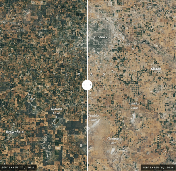
A side-by-side satellite image comparison of a region in Texas, showing conditions on September 22, 2025 (left) and September 9, 2026 (right). The left image displays a patchwork of dark green and brown agricultural fields with noticeable bodies of water, including Rich Lake and Mound Lake. The right image shows a noticeably dryer, more arid landscape dominated by tan and pale brown fields, with significantly reduced vegetation and dried-up or lightened lake beds labeled Double Lakes, Guthrie Lake, Tahoka L

NASA Earth Observatory’s Image of the Day features NASA Acres’ work connecting satellite data, NASA scientists and Texas farmers to better understand drought impacts and address agricultural challenges.

A recent NASA Earth Observatory Image of the Day takes a closer look at drought in the Texas High Plains, what it means for the farmers experiencing it firsthand, and how NASA Acres is engaging with producers to better understand where NASA Earth science can help address these challenges.

“This is the first year that we’ve had cotton completely die.”

That’s how NASA Acres Farm Innovation Ambassador Team (FIAT) member Lacy Cotter Vardeman describes the impact of this year’s drought on her farm.

The Earth Observatory feature, “Fighting Drought in Texas Cotton Country,” uses Landsat imagery to show the stark difference between conditions around Lubbock in September 2025 and September 2026—while telling the story of what those changes mean on the ground for farmers and communities across the region.

The story features perspectives from Lacy and fellow Texas FIAT member Tillery Timmons-Sims, who helps lead the Sandhills Area Research Association, and discusses the growing pressure on the High Plains aquifer, as well as the increasingly urgent need for information and solutions that can help producers adapt.

It also looks back at the NASA Space for Agriculture (Space4Ag) listening tour through Texas this August, when NASA Earth Science leaders and scientists joined NASA Acres, FIAT members and agricultural partners in the field to hear directly from producers about drought, groundwater, playa lakes and the challenges shaping the future of agriculture in the High Plains.

Together, the imagery and firsthand perspectives show why those conversations matter: connecting the view from space with the knowledge and experience of the people managing these landscapes every day.

Read the full NASA Earth Observatory story.

This article was written by Adam Zwerner and originally published on the NASA Acres website. NASA Acres is NASA’s Agriculture Consortium based at the University of Maryland.

Image: Screenshot of NASA Earth Observatory Image of the Day

Published on Thu, 10/29/2026 - 14:26

College of Behavioral & Social Sciences
  • Facebook
  • Twitter
  • Instagram
  • YouTube
  • LinkedIn
  • Zenfolio

Department of Geographical Sciences

2181 Samuel J. LeFrak Hall, 7251 Preinkert Drive,
University of Maryland, College Park, MD 20742
Phone: 301-405-4050

Subscribe to Our Newsletter

Contact Us

Links
  • UMD Land Acknowledgement
  • UMD Staff Directory
  • Give to GEOG
  • UMD Web Accessibility
  • Alumni
© 2026 College of Behavioral & Social Sciences. All Rights Reserved.
Login