UMD College of Behavorial & Social Sciences UMD College of Behavorial & Social Sciences
MENU

Topbar Menu

  • About Us
  • People
  • Alumni and Giving
  • Diversity
  • Undergraduate
    • Prospective Students
    • Courses & Facilities
    • Advising
    • Special Programs
    • Graduation
    • Geography Club
  • Graduate
    • Prospective Ph.D. Students
    • Graduate Courses
    • Graduate Student Publications
    • Graduate Student Awards
    • Graduate Students
    • Master of Science and Graduate Certificate Programs
    • Combined BS/MS Program
  • Research
    • Research Areas
      • Geospatial-Information Science and Remote Sensing
      • Human Dimensions of Global Change
      • Land Cover and Land Use Change
      • Carbon, Vegetation Dynamics and Landscape-Scale Processes
    • Centers
      • Center for Geospatial Information Science
      • International Center for Innovation in Geospatial Analytics & Earth Observation
  • High School Hub
    • Program Overview
    • High School Awards
    • High School Internship Program
    • GIS Day
  • Resources
    • Graduate Student Organization
    • Student Life
    • Graduate School
    • Responsible Conduct of Research
    • Emergency Preparedness
    • Job Opportunities
    • Graduation
Search

Main navigation

  • Undergraduate
    • Prospective Students
    • Courses & Facilities
    • Advising
    • Special Programs
    • Graduation
    • Geography Club
  • Graduate
    • Prospective Ph.D. Students
    • Graduate Courses
    • Graduate Student Publications
    • Graduate Student Awards
    • Graduate Students
    • Master of Science and Graduate Certificate Programs
    • Combined BS/MS Program
  • Research
    • Research Areas
      • Geospatial-Information Science and Remote Sensing
      • Human Dimensions of Global Change
      • Land Cover and Land Use Change
      • Carbon, Vegetation Dynamics and Landscape-Scale Processes
    • Centers
      • Center for Geospatial Information Science
      • International Center for Innovation in Geospatial Analytics & Earth Observation
  • High School Hub
    • Program Overview
    • High School Awards
    • High School Internship Program
    • GIS Day
  • Resources
    • Graduate Student Organization
    • Student Life
    • Graduate School
    • Responsible Conduct of Research
    • Emergency Preparedness
    • Job Opportunities
    • Graduation
  • About Us
  • People
  • Alumni and History
  • Diversity

Search our site:

Mapping Sea Ice Surface Topography in High Fidelity with ICESat-2

Breadcrumb

  • Home
  • Featured Content
  • Mapping Sea Ice Surface Topography In High Fidelity With ICESat-2
Imagery of Sea Ice in the Arctic Ocean

Dr. Sinead Farrell [GEOG Associate Professor] recently published a paper in the Geophysical Research Letters (GRL) - ICESat-2 Special Issue focused on using new technologies to measure the impacts of climate change on the environment.

One of the most striking environmental changes underway in the Earth system is the disappearance of the Arctic sea ice cover. Anomalously warm weather in the Arctic in 2020 caused sea ice to retreat to its second-lowest extent in the modern record, a record derived from over 40 years of satellite observations.

Sea Ice Melt in the Arctic Ocean
Sea ice floes in the Arctic Ocean undergoing melt. Azure blue ponds of meltwater collect atop white ice floes, and eventually drain to the darker, exposed ocean through channels and thaw holes. Researchers are now demonstrating novel ways to measure the depth of these ponds with remote sensing techniques. Image credit: R. Dominguez/NASA/NSIDC

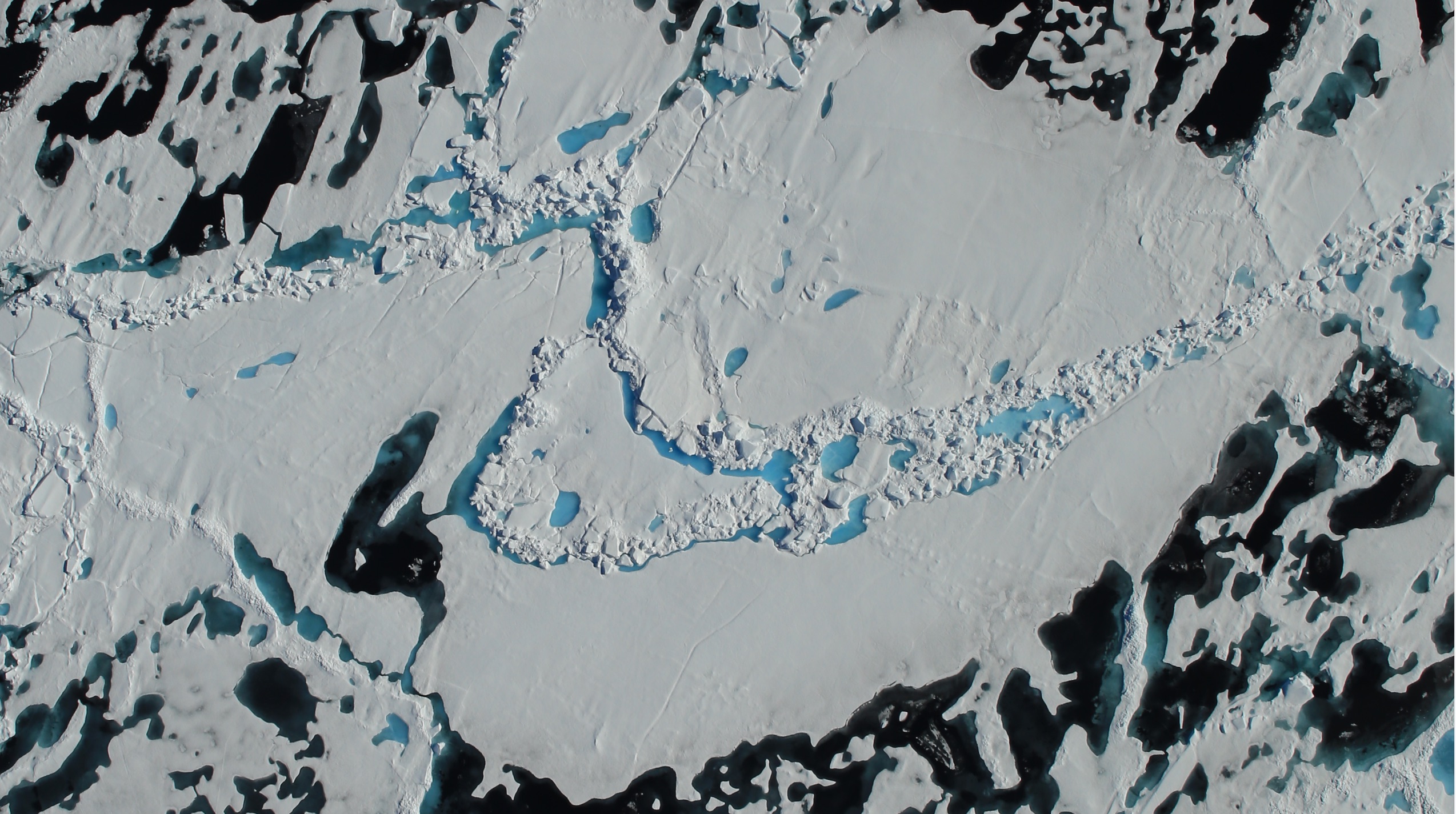
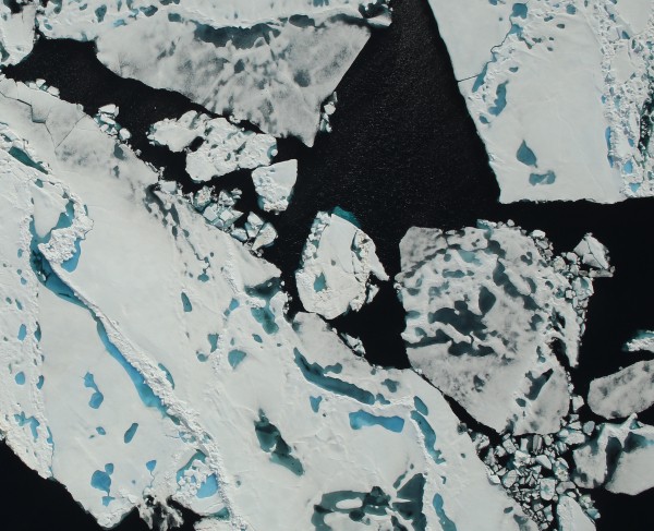
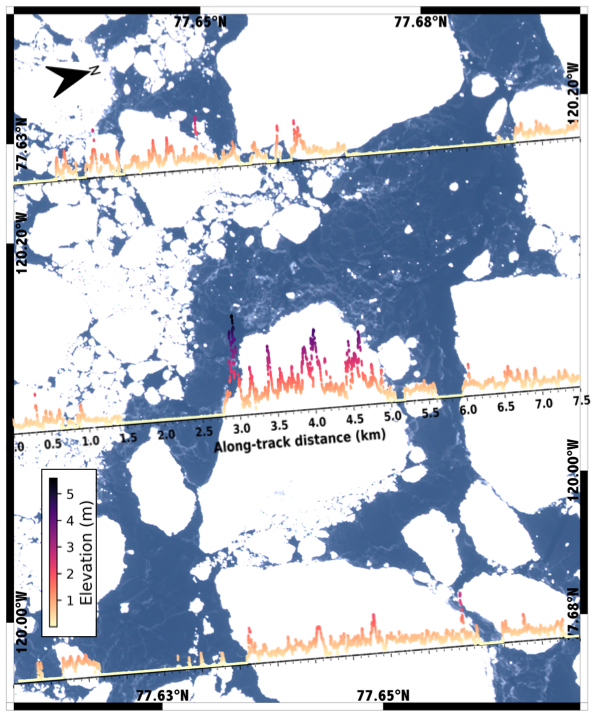
Scientists at the University of Maryland have demonstrated that NASA’s ICESat-2 satellite provides a new remote-sensing capability to measure the complex sea ice surface, at meter-scale resolution. Detailed measurements of the sea ice cover provide us with a better understanding of the physical processes shaping the ice cover and offer insights about its vulnerability to further decline. Researchers, including and graduate students at the University of Maryland, used measurements from ICESat-2 to derive a suite of important sea ice properties related to the drift, melt and growth of the ice cover. They discovered that ICESat-2 is capable of measuring the smallest features on the ice cover, including narrow pressure ridges and cracks in the ice just 10 m wide, and small sea ice floes just 20 m across. The team revealed that ICESat-2 has the ability to identify individual melt ponds on multiyear sea ice in summer, that were less than 1 m deep, on average. This marks the first time that the depth of summer melt ponds on sea ice have been measured using a space-based altimeter instrument.

Next the team hope to use ICESat-2 observations together the field measurements to investigate time-varying sea ice processes. Results from this work will help to improve sea ice models used to predict the future of the Arctic ice cover.

Multi-satellite observations of sea ice floes in the Arctic Ocean
Multi-satellite observations of sea ice floes in the Arctic Ocean. ICESat-2 altimeter measurements of sea ice elevation (graduated, colored lines) are draped over coincident imagery from the Sentinel-2 satellite. The data reveal white sea ice floes, ranging in size from 50 m to over 2 km wide, with rough surface topography. In between the ice floes is a matrix of darker, smooth nilas ice, where the sea surface has just re-frozen at the beginning of winter. Figure credit: Farrell et al., 2020. 


Published on Tue, 10/20/2020 - 13:13

College of Behavorial & Social Sciences
  • Facebook
  • Twitter
  • Instagram
  • YouTube
  • LinkedIn
  • Zenfolio

Department of Geographical Sciences

2181 Samuel J. LeFrak Hall, 7251 Preinkert Drive,
University of Maryland, College Park, MD 20742
Phone: 301-405-4050

Join Our Newsletter

Contact Us

Links
  • UMD Land Acknowledgement
  • UMD Staff Directory
  • Give to GEOG
  • UMD Web Accessibility
  • Alumni
© 2025 College of Behavorial & Social Sciences. All Rights Reserved.
Login