
Mapping Global Land Cover Extent and Change Using Landsat Data
The research team of Matthew Hansen, Peter Potapov, and Svetlana Turubanova has recently been awarded a two-year $1.7 million dollar award to prototype global land cover extent and change mapping capabilities using Landsat data. The award comes from the Gordon and Betty Moore Foundation, which has a history of funding research in support of environmental monitoring and sustainability. Specifically, the proposal seeks to mine the Landsat archive in creating spatially and temporally consistent depictions of global land cover.
The idea is to produce quantifications of land surface dynamics that are meaningful from local to global scales. Dr. Hansen began his global land cover characterization work in the Department of Geographical Sciences at the University of Maryland, College Park, in the 1990’s, helping to develop and implement global maps from AVHRR and MODIS data, including the MODIS Vegetation Continuous Fields layers. These maps have been incorporated in numerous earth system studies as well as popular science venues, including regular use of the VCF layers in National Geographic map inserts and atlases.
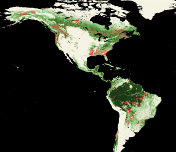
More recently, the team has incorporated Landsat data in global-scale studies of forest extent and change. A recent Proceedings of the National Academy of Sciences article described their work in performing the first global forest cover extent change analysis using both MODIS and Landsat in a sample-based strategy. The figure below illustrates a global MODIS forest cover loss indicator product that can be used to guide the allocation of samples of Landsat or other higher spatial resolution data in estimating area change.
Work with USAID CARPE (Central Africa Regional Program for the Environment), a long-tenured project led by Dr. Chris Justice, enabled Hansen and others to develop a system for mapping national-scale land cover and change by mining all available Landsat imagery over the Democratic Republic of the Congo. A generic processing system has been developed and tested in Brazil, Mexico, the Republic of Congo, Tanzania, Indonesia, Quebec, Canada, and European Russia. For these studies, over 100,000 images have been processed to evaluate all pixels for use in forest characterization. The Moore Foundation activity will involve the processing of over 1,000,000 Landsat images to extend the method globally for the period 1999 to 2011.
The primary partner for the project is the USGS center for Earth Resources Observation and Science (EROS). Dr. Tom Loveland of EROS is leading a Global Land Cover Initiative and the Moore Foundation activity will support methods development for operational global land monitoring systems. GoogleOutreach is also a partner as the team tests methods with the GoogleEarthEngine cloud computing system, led by Dr. Rebecca Moore. Results over the next two years will illustrate the capabilities of Landsat in systematically quantifying land surface dynamics at the global scale, an exciting prospect.
Published on Thu, 02/23/2012 - 15:02