UMD College of Behavorial & Social Sciences UMD College of Behavorial & Social Sciences
MENU

Topbar Menu

  • About Us
  • People
  • Alumni and Giving
  • Diversity
  • Undergraduate
    • Prospective Students
    • Courses & Facilities
    • Advising
    • Special Programs
    • Graduation
    • Geography Club
  • Graduate
    • Prospective Ph.D. Students
    • Graduate Courses
    • Graduate Student Publications
    • Graduate Student Awards
    • Graduate Students
    • Master of Science and Graduate Certificate Programs
    • Combined BS/MS Program
  • Research
    • Research Areas
      • Geospatial-Information Science and Remote Sensing
      • Human Dimensions of Global Change
      • Land Cover and Land Use Change
      • Carbon, Vegetation Dynamics and Landscape-Scale Processes
    • Centers
      • Center for Geospatial Information Science
      • International Center for Innovation in Geospatial Analytics & Earth Observation
  • High School Hub
    • Program Overview
    • High School Awards
    • High School Internship Program
    • GIS Day
  • Resources
    • Graduate Student Organization
    • Student Life
    • Graduate School
    • Responsible Conduct of Research
    • Emergency Preparedness
    • Job Opportunities
    • Graduation
Search

Main navigation

  • Undergraduate
    • Prospective Students
    • Courses & Facilities
    • Advising
    • Special Programs
    • Graduation
    • Geography Club
  • Graduate
    • Prospective Ph.D. Students
    • Graduate Courses
    • Graduate Student Publications
    • Graduate Student Awards
    • Graduate Students
    • Master of Science and Graduate Certificate Programs
    • Combined BS/MS Program
  • Research
    • Research Areas
      • Geospatial-Information Science and Remote Sensing
      • Human Dimensions of Global Change
      • Land Cover and Land Use Change
      • Carbon, Vegetation Dynamics and Landscape-Scale Processes
    • Centers
      • Center for Geospatial Information Science
      • International Center for Innovation in Geospatial Analytics & Earth Observation
  • High School Hub
    • Program Overview
    • High School Awards
    • High School Internship Program
    • GIS Day
  • Resources
    • Graduate Student Organization
    • Student Life
    • Graduate School
    • Responsible Conduct of Research
    • Emergency Preparedness
    • Job Opportunities
    • Graduation
  • About Us
  • People
  • Alumni and History
  • Diversity

Search our site:

GLAD Team’s Collaboration Helps Nepal Achieve Major Milestone in Land Monitoring

Breadcrumb

  • Home
  • Featured Content
  • GLAD Team’s Collaboration Helps Nepal Achieve Major Milestone In Land Monitoring
FRTC Director General Dr. Rajendra KC  launches the National Land Cover Monitoring System on Dec. 20 in Kathmandu, Nepal..

Launch of the National Land Cover Monitoring System marks a new era for Nepal’s environmental sustainability efforts.

The University of Maryland’s Global Land Analysis and Discovery (GLAD) team, led by Research Professor Peter Potapov, has partnered with Nepal’s Ministry of Forests and Environment to co-develop the National Land Cover Monitoring System (NLCMS). This new system will enhance Nepal’s ability to track and manage its land resources. GLAD provided critical support by boosting the Ministry's technical capacity and offering essential hardware and data inputs.

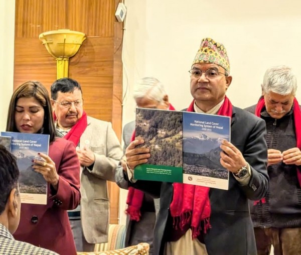
The NLCMS, which is now fully owned and operated by the Ministry, was officially launched on Dec. 20, 2024, marking a major step in Nepal's efforts to monitor environmental changes.

This launch follows the release of a report showing that Nepal's forest cover increased by 0.75% in 2022 compared to 2019. Conducted by the Forest Research and Training Center (FRTC) and the International Centre for Integrated Mountain Development (ICIMOD), the study revealed that in 2022, 46.08% of Nepal’s land area was covered by forests and other wooded lands, a slight increase from 45.33% in 2019.

FRTC Director General Dr. Rajendra KC explained that the increase in forest cover resulted from a transformation of other wooded and cultivable land into forests. The study provides valuable, real-time data on land-cover changes, offering insights that will be useful for national and international organizations, policy development and strategic forest planning.

NLCMS Report
 

Image: FRTC Director General Dr. Rajendra KC  launches the National Land Cover Monitoring System on Dec. 20 in Kathmandu, Nepal. Courtesy of UMD's GLAD.

Published on Mon, 01/13/2025 - 16:17

College of Behavorial & Social Sciences
  • Facebook
  • Twitter
  • Instagram
  • YouTube
  • LinkedIn
  • Zenfolio

Department of Geographical Sciences

2181 Samuel J. LeFrak Hall, 7251 Preinkert Drive,
University of Maryland, College Park, MD 20742
Phone: 301-405-4050

Join Our Newsletter

Contact Us

Links
  • UMD Land Acknowledgement
  • UMD Staff Directory
  • Give to GEOG
  • UMD Web Accessibility
  • Alumni
© 2025 College of Behavorial & Social Sciences. All Rights Reserved.
Login