GEOG Researchers Publish Major New Land Use Dataset for Use In Next Generation Global Climate Change Studies
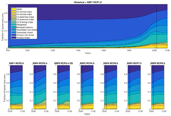
GEOG researchers George Hurtt, Louise Chini, Ritvik Sahajpal, Jennifer Kennedy, Lei Ma, and Ben Poulter led an international team of scientists in the harmonization of global land-use data for use in the next generation of advanced Earth System Models designed to estimate the combined effects human activities (e.g. land use and fossil fuel emissions) on the Earth's coupled carbon-climate system. The datasets are part of the official World Climate Research Program Coupled Model Intercomparison Project (CMIP6) input4MIPs data collection and are required forcing datasets for Diagnostic, Evaluation, and Clarification of Klima (DECK) and historical climate simulations. The data are also required for several of the CMIP6 model intercomparison experiments including ScenarioMIP, LUMIP, PMIP, and others. ScenarioMIP defined the set of future scenarios for consideration and organized the official climate–model experiment to quantify the effects of future scenarios of anthropogenic forcing on climate. LUMIP organized the set of model experiments focused on quantifying the effect of land use forcing per se on climate. PMIP is organized to study the historical climate. The central use of these data in the DECK and across a range of important MIPs enhances consistency across CMIP6 relative to prior assessments. These datasets have also been adopted as required forcing for a range of other international studies including the Inter-Sectoral Impact Model Intercomparison Project (ISIMIP), the Global Carbon Project (GCP), and the Intergovernmental Science-Policy Platform on Biodiversity and Ecosystem Services (IPBES). The paper, published in the journal Geoscientific Model Development, is entitled "Harmonization of global land use change and management for the period 850-2100" (https://doi.org/10.5194/gmd-13-5425-2020). The abstract of the paper is provided below:
Human land use activities have resulted in large changes to the biogeochemical and biophysical properties of the Earth’s surface, with consequences for climate and other ecosystem services. In the future, land use activities are likely to expand and/or intensify further to meet grow- ing demands for food, fiber, and energy. As part of the World Climate Research Program Coupled Model Intercom- parison Project (CMIP6), the international community has developed the next generation of advanced Earth system models (ESMs) to estimate the combined effects of human activities (e.g., land use and fossil fuel emissions) on the carbon–climate system. A new set of historical data based on the History of the Global Environment database (HYDE), and multiple alternative scenarios of the future (2015–2100) from Integrated Assessment Model (IAM) teams, is required as input for these models. With most ESM simulations for CMIP6 now completed, it is important to document the land use patterns used by those simulations. Here we present results from the Land-Use Harmonization 2 (LUH2) project, which smoothly connects updated historical reconstructions of land use with eight new future projections in the format required for ESMs. The harmonization strategy estimates the fractional land use patterns, underlying land use transi- tions, key agricultural management information, and result- ing secondary lands annually, while minimizing the differ- ences between the end of the historical reconstruction and IAM initial conditions and preserving changes depicted by the IAMs in the future. The new approach builds on a similar effort from CMIP5 and is now provided at higher resolution (0.25◦ × 0.25◦) over a longer time domain (850–2100, with extensions to 2300) with more detail (including multiple crop and pasture types and associated management practices) us- ing more input datasets (including Landsat remote sensing data) and updated algorithms (wood harvest and shifting cultivation); it is assessed via a new diagnostic package. The new LUH2 products contain > 50 times the information con- tent of the datasets used in CMIP5 and are designed to enable new and improved estimates of the combined effects of land use on the global carbon–climate system.

Published on Wed, 11/18/2020 - 11:14

