UMD College of Behavorial & Social Sciences UMD College of Behavorial & Social Sciences
MENU

Topbar Menu

  • About Us
  • People
  • Alumni and Giving
  • Diversity
  • Undergraduate
    • Prospective Students
    • Courses & Facilities
    • Advising
    • Special Programs
    • Graduation
    • Geography Club
  • Graduate
    • Prospective Ph.D. Students
    • Graduate Courses
    • Graduate Student Publications
    • Graduate Student Awards
    • Graduate Students
    • Master of Science and Graduate Certificate Programs
    • Combined BS/MS Program
  • Research
    • Research Areas
      • Geospatial-Information Science and Remote Sensing
      • Human Dimensions of Global Change
      • Land Cover and Land Use Change
      • Carbon, Vegetation Dynamics and Landscape-Scale Processes
    • Centers
      • Center for Geospatial Information Science
      • International Center for Innovation in Geospatial Analytics & Earth Observation
  • High School Hub
    • Program Overview
    • High School Awards
    • High School Internship Program
    • GIS Day
  • Resources
    • Graduate Student Organization
    • Student Life
    • Graduate School
    • Responsible Conduct of Research
    • Emergency Preparedness
    • Job Opportunities
    • Graduation
Search

Main navigation

  • Undergraduate
    • Prospective Students
    • Courses & Facilities
    • Advising
    • Special Programs
    • Graduation
    • Geography Club
  • Graduate
    • Prospective Ph.D. Students
    • Graduate Courses
    • Graduate Student Publications
    • Graduate Student Awards
    • Graduate Students
    • Master of Science and Graduate Certificate Programs
    • Combined BS/MS Program
  • Research
    • Research Areas
      • Geospatial-Information Science and Remote Sensing
      • Human Dimensions of Global Change
      • Land Cover and Land Use Change
      • Carbon, Vegetation Dynamics and Landscape-Scale Processes
    • Centers
      • Center for Geospatial Information Science
      • International Center for Innovation in Geospatial Analytics & Earth Observation
  • High School Hub
    • Program Overview
    • High School Awards
    • High School Internship Program
    • GIS Day
  • Resources
    • Graduate Student Organization
    • Student Life
    • Graduate School
    • Responsible Conduct of Research
    • Emergency Preparedness
    • Job Opportunities
    • Graduation

Search our site:

GEOG Researchers Create the First Global 30m GEDI-Based Forest Canopy Height Map

Breadcrumb

  • Home
  • Featured Content
  • GEOG Researchers Create The First Global 30m GEDI-Based Forest Canopy Height Map
Global forest canopy height map

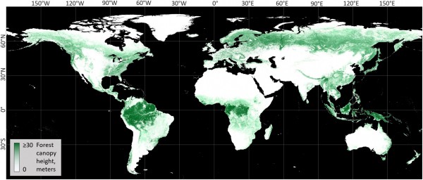
A new, 30-m spatial resolution global forest canopy height map was developed through the integration of the Global Ecosystem Dynamics Investigation (GEDI) lidar forest structure measurements and Landsat analysis-ready data time-series. The NASA GEDI is a spaceborne lidar instrument operating onboard the International Space Station since April 2019. It provides footprint-based measurements of vegetation structure, including forest canopy height between 52°N and 52°S globally. The Global Land Analysis and Discover team at the University of Maryland (UMD GLAD) integrated the GEDI data available to date (April-October 2019) with the year 2019 Landsat analysis-ready time-series data (Landsat ARD). The GEDI RH95 (relative height at 95%) metric was used to calibrate the model. The Landsat multi-temporal metrics that represent the surface phenology serve as the independent variables for global forest height modeling. The “moving window” locally calibrated and applied bagged regression tree ensemble model was implemented to ensure high quality of forest height prediction and global map consistency. The model was extrapolated in the boreal regions (beyond the GLAD data range) to create the global forest height prototype map.

The global forest height map is a prototype product that has known issues related to GEDI data quality and Landsat optical time-series data availability and feasibility of characterizing forest structure. GEDI data overestimate forest height on slopes within temperate and subtropical mountain grasslands, e.g. in New Zealand and Lesotho. Tree height over cities and suburbs may be confounded with building height, as GEDI data do not discriminate between the height of vegetation and man-made objects. The GEDI calibration uncertainties (specifically, geolocation precision and land surface height estimation) may be responsible for some of the map errors. The forest height model saturated above 30m and does not adequately represent the height of the tallest trees. The global product will be updated in the future to address most of the issues. The newly processed GEDI data will include refinements to land surface detection algorithms, an urban mask, and improved geolocation. Planned integration of higher spatial resolution Sentinel-2 data will allow the implementation of texture metrics. Application of advanced machine learning tools (namely, convolution neural networks) will be tested to improve forest height modeling accuracy.

Dataset Reference: P. Potapov, X. Li, A. Hernandez-Serna, A. Tyukavina, M.C. Hansen, A. Kommareddy, A. Pickens, S. Turubanova, H. Tang, C.E. Silva, J. Armston, R. Dubayah, J. B. Blair, M. Hofton (2020) Mapping and monitoring global forest canopy height through integration of GEDI and Landsat data. In review

Interactive map: https://glad.earthengine.app/view/global-forest-canopy-height-2019

Data description and download: https://glad.umd.edu/dataset/gedi/

Global forest canopy height map


Published on Fri, 08/21/2020 - 14:41

College of Behavorial & Social Sciences
  • Facebook
  • Twitter
  • Instagram
  • YouTube
  • LinkedIn
  • Zenfolio

Department of Geographical Sciences

2181 Samuel J. LeFrak Hall, 7251 Preinkert Drive,
University of Maryland, College Park, MD 20742
Phone: 301-405-4050

Join Our Newsletter

Contact Us

Links
  • UMD Land Acknowledgement
  • UMD Staff Directory
  • Give to GEOG
  • UMD Web Accessibility
  • Alumni
© 2025 College of Behavorial & Social Sciences. All Rights Reserved.
Login