UMD College of Behavorial & Social Sciences UMD College of Behavorial & Social Sciences
MENU

Topbar Menu

  • About Us
  • People
  • Alumni and Giving
  • Diversity
  • Undergraduate
    • Prospective Students
    • Courses & Facilities
    • Advising
    • Special Programs
    • Graduation
    • Geography Club
  • Graduate
    • Prospective Ph.D. Students
    • Graduate Courses
    • Graduate Student Publications
    • Graduate Student Awards
    • Graduate Students
    • Master of Science and Graduate Certificate Programs
    • Combined BS/MS Program
  • Research
    • Research Areas
      • Geospatial-Information Science and Remote Sensing
      • Human Dimensions of Global Change
      • Land Cover and Land Use Change
      • Carbon, Vegetation Dynamics and Landscape-Scale Processes
    • Centers
      • Center for Geospatial Information Science
      • International Center for Innovation in Geospatial Analytics & Earth Observation
  • High School Hub
    • Program Overview
    • High School Awards
    • High School Internship Program
    • GIS Day
  • Resources
    • Graduate Student Organization
    • Student Life
    • Graduate School
    • Responsible Conduct of Research
    • Emergency Preparedness
    • Job Opportunities
    • Graduation
Search

Main navigation

  • Undergraduate
    • Prospective Students
    • Courses & Facilities
    • Advising
    • Special Programs
    • Graduation
    • Geography Club
  • Graduate
    • Prospective Ph.D. Students
    • Graduate Courses
    • Graduate Student Publications
    • Graduate Student Awards
    • Graduate Students
    • Master of Science and Graduate Certificate Programs
    • Combined BS/MS Program
  • Research
    • Research Areas
      • Geospatial-Information Science and Remote Sensing
      • Human Dimensions of Global Change
      • Land Cover and Land Use Change
      • Carbon, Vegetation Dynamics and Landscape-Scale Processes
    • Centers
      • Center for Geospatial Information Science
      • International Center for Innovation in Geospatial Analytics & Earth Observation
  • High School Hub
    • Program Overview
    • High School Awards
    • High School Internship Program
    • GIS Day
  • Resources
    • Graduate Student Organization
    • Student Life
    • Graduate School
    • Responsible Conduct of Research
    • Emergency Preparedness
    • Job Opportunities
    • Graduation
  • About Us
  • People
  • Alumni and History
  • Diversity

Search our site:

GEOG Researchers awarded NASA Carbon Monitoring System program grant

Breadcrumb

  • Home
  • Featured Content
  • GEOG Researchers Awarded NASA Carbon Monitoring System Program Grant
US Croplands

A Department of Geographical Sciences research team had a CMS proposal funded to create a prototype of a Cropland Carbon Monitoring System (CCMS) that improves the existing cropland C storage and flux estimates developed under previous NASA CMS activities in terms of spatial and temporal scales as well as completeness.  The University of Maryland's Department of Geographical Sciences research team of Dr. César Izaurralde (PI), Dr. Varaprasad (Prasad) Bandaru (Science PI), Dr. George Hurtt (Co-I), Dr. Chris Justice, Dr. Fernando Sedano (Co-I), Dr. Ritvik Sahajpal (Co-I), Dr. Curtis Jones and Mr. Ashwan Reddy has been awarded a research grant of $1.3 million dollars by NASA’s Carbon Monitoring System program for their project titled “Cropland Carbon Monitoring System (CCMS): A satellite-based system to estimate carbon fluxes on U.S croplands”. Other co-investigators and collaborators are Dr. Prasanna Gowda, USDA-ARS, El Reno, OK; Dr. Jerry L. Hatfield, USDA-ARS, Ames, IA; Dr. Craig Daughtry, USDA-ARS, Beltsville, MD; Dr. Eric Vermote, NASA GSFC, Greenbelt, MD; Dr. Ramakrishna Nemani, NASA Ames, Moffett Field, CA; and Stephen J. Del Grosso, USDA-ARS, Fort Collins, CO.

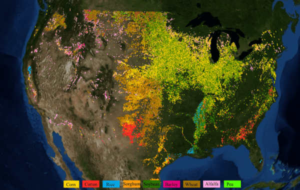
The primary goal of this proposal is to create a prototype of a Cropland Carbon Monitoring System (CCMS) that improves the existing cropland C storage and flux estimates developed under previous NASA CMS activities in terms of spatial and temporal scales as well as completeness. This project will use RS-EPIC developed as part of Global Agricultural Monitoring Program (GEO-GLAM) to estimate, at 500-m resolution, the 2015-2016 seasonal and annual C fluxes of nine major crops (corn, soybean, winter wheat, spring wheat sorghum, cotton, alfalfa, barley, rice, and peas) grown over ~96% of the cropland area in the conterminous United States. The product developed under this project will provide the knowledge base at required spatial and temporal scale to understand complex carbon cycling outcomes under various land use and land management practices and develop joint policies to meet objectives of food and energy security while stabilizing atmospheric CO2. Further, the data product will help improve national inventories and carbon budget reporting.

Published on Fri, 08/12/2016 - 16:51

College of Behavorial & Social Sciences
  • Facebook
  • Twitter
  • Instagram
  • YouTube
  • LinkedIn
  • Zenfolio

Department of Geographical Sciences

2181 Samuel J. LeFrak Hall, 7251 Preinkert Drive,
University of Maryland, College Park, MD 20742
Phone: 301-405-4050

Join Our Newsletter

Contact Us

Links
  • UMD Land Acknowledgement
  • UMD Staff Directory
  • Give to GEOG
  • UMD Web Accessibility
  • Alumni
© 2025 College of Behavorial & Social Sciences. All Rights Reserved.
Login