UMD College of Behavorial & Social Sciences UMD College of Behavorial & Social Sciences
MENU

Topbar Menu

  • About Us
  • People
  • Alumni and Giving
  • Diversity
  • Undergraduate
    • Prospective Students
    • Courses & Facilities
    • Advising
    • Special Programs
    • Graduation
    • Geography Club
  • Graduate
    • Prospective Ph.D. Students
    • Graduate Courses
    • Graduate Student Publications
    • Graduate Student Awards
    • Graduate Students
    • Master of Science and Graduate Certificate Programs
    • Combined BS/MS Program
  • Research
    • Research Areas
      • Geospatial-Information Science and Remote Sensing
      • Human Dimensions of Global Change
      • Land Cover and Land Use Change
      • Carbon, Vegetation Dynamics and Landscape-Scale Processes
    • Centers
      • Center for Geospatial Information Science
      • International Center for Innovation in Geospatial Analytics & Earth Observation
  • High School Hub
    • Program Overview
    • High School Awards
    • High School Internship Program
    • GIS Day
  • Resources
    • Graduate Student Organization
    • Student Life
    • Graduate School
    • Responsible Conduct of Research
    • Emergency Preparedness
    • Job Opportunities
    • Graduation
Search

Main navigation

  • Undergraduate
    • Prospective Students
    • Courses & Facilities
    • Advising
    • Special Programs
    • Graduation
    • Geography Club
  • Graduate
    • Prospective Ph.D. Students
    • Graduate Courses
    • Graduate Student Publications
    • Graduate Student Awards
    • Graduate Students
    • Master of Science and Graduate Certificate Programs
    • Combined BS/MS Program
  • Research
    • Research Areas
      • Geospatial-Information Science and Remote Sensing
      • Human Dimensions of Global Change
      • Land Cover and Land Use Change
      • Carbon, Vegetation Dynamics and Landscape-Scale Processes
    • Centers
      • Center for Geospatial Information Science
      • International Center for Innovation in Geospatial Analytics & Earth Observation
  • High School Hub
    • Program Overview
    • High School Awards
    • High School Internship Program
    • GIS Day
  • Resources
    • Graduate Student Organization
    • Student Life
    • Graduate School
    • Responsible Conduct of Research
    • Emergency Preparedness
    • Job Opportunities
    • Graduation
  • About Us
  • People
  • Alumni and History
  • Diversity

Search our site:

GEOG Professor Co-Authors New Paper Calling for an Integrative Approach to Remote Sensing, Biodiversity Conservation

Breadcrumb

  • Home
  • Featured Content
  • GEOG Professor Co-Authors New Paper Calling For An Integrative Approach To Remote Sensing, Biodiversity Conservation
Underwater view of coral reef with mountains and sky above

In a new Nature Ecology and Evolution perspective paper co-authored by George Hurtt, a professor in the Department of Geographical Sciences, experts argue that pairing remote sensing—which involves the collection of aerial imagery and other data from instruments such as drones, planes, and satellites—with on-the-ground observations and other biodiversity knowledge can provide a powerful framework for understanding, monitoring, and protecting biodiversity. 

The paper specifically addresses 2050 targets set by the international Convention on Biodiversity, including reducing the rate of extinction tenfold, reducing the risk of extinction by 50%, and maintaining at least 90% of genetic diversity within all species. It also discusses the challenges associated with effectively addressing those targets, plus the ways that they can be overcome—solutions largely drawn from the experts’ participation in the February 2020 Inaugural World Biodiversity Forum held in Davos, Switzerland.

“While remote sensing can contribute in fundamental ways to monitoring biodiversity change, it cannot meet the monitoring needs for the goals and milestones of the Convention on Biodiversity post-2020 framework,” said lead author Jeannine Cavender-Bares, a Distinguished McKnight University Professor of ecology, evolution and behavior at the University of Minnesota.

Echoing Cavender-Bares’ thoughts, Hurtt said, “Many important aspects of biodiversity are not directly observable through remote sensors alone. From genetics, to on-the-ground calibration and validation, to socioeconomic considerations, to future dynamics, understanding requires integration across a broad set of approaches.” 

Figure illustrating integration of remote sensing and other tools to understand Earth biodiversity
The integration of remote sensing and in situ observations, experiments and models as tools to understand biodiversity in the Earth system (Cavender-Bares et al. 2022)

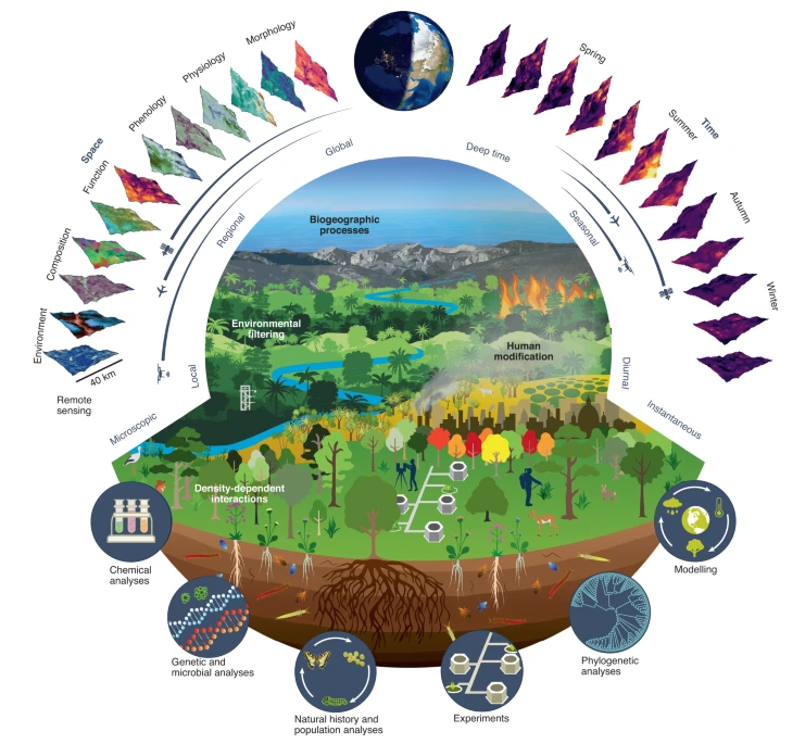
It also requires global collaboration amongst scientists, organizations, and communities, the paper’s authors note. Regarding the latter, the experts call for greater consideration of the knowledge, needs and perspectives of Indigenous Peoples, who manage a substantial fraction of protected lands globally.

Fortunately, collaborative models already exist, the authors citing the Group on Earth Observations Biodiversity Observation Network (GEO BON) as an example of what this work can look like. 

“Protecting biodiversity is one of society's grand challenges,” said Hurtt. “Scientists from multiple disciplines and diverse technical expertises, policymakers, and stakeholders need to be involved and coordinated. This needs to be an all-hands effort.”

For more information and to read the full article, click here. Main photo provided by iStock.

Published on Fri, 03/25/2022 - 11:57

College of Behavorial & Social Sciences
  • Facebook
  • Twitter
  • Instagram
  • YouTube
  • LinkedIn
  • Zenfolio

Department of Geographical Sciences

2181 Samuel J. LeFrak Hall, 7251 Preinkert Drive,
University of Maryland, College Park, MD 20742
Phone: 301-405-4050

Join Our Newsletter

Contact Us

Links
  • UMD Land Acknowledgement
  • UMD Staff Directory
  • Give to GEOG
  • UMD Web Accessibility
  • Alumni
© 2025 College of Behavorial & Social Sciences. All Rights Reserved.
Login