UMD College of Behavorial & Social Sciences UMD College of Behavorial & Social Sciences
MENU

Topbar Menu

  • About Us
  • People
  • Alumni and Giving
  • Diversity
  • Undergraduate
    • Prospective Students
    • Courses & Facilities
    • Advising
    • Special Programs
    • Graduation
    • Geography Club
  • Graduate
    • Prospective Ph.D. Students
    • Graduate Courses
    • Graduate Student Publications
    • Graduate Student Awards
    • Graduate Students
    • Master of Science and Graduate Certificate Programs
    • Combined BS/MS Program
  • Research
    • Research Areas
      • Geospatial-Information Science and Remote Sensing
      • Human Dimensions of Global Change
      • Land Cover and Land Use Change
      • Carbon, Vegetation Dynamics and Landscape-Scale Processes
    • Centers
      • Center for Geospatial Information Science
      • International Center for Innovation in Geospatial Analytics & Earth Observation
  • High School Hub
    • Program Overview
    • High School Awards
    • High School Internship Program
    • GIS Day
  • Resources
    • Graduate Student Organization
    • Student Life
    • Graduate School
    • Responsible Conduct of Research
    • Emergency Preparedness
    • Job Opportunities
    • Graduation
Search

Main navigation

  • Undergraduate
    • Prospective Students
    • Courses & Facilities
    • Advising
    • Special Programs
    • Graduation
    • Geography Club
  • Graduate
    • Prospective Ph.D. Students
    • Graduate Courses
    • Graduate Student Publications
    • Graduate Student Awards
    • Graduate Students
    • Master of Science and Graduate Certificate Programs
    • Combined BS/MS Program
  • Research
    • Research Areas
      • Geospatial-Information Science and Remote Sensing
      • Human Dimensions of Global Change
      • Land Cover and Land Use Change
      • Carbon, Vegetation Dynamics and Landscape-Scale Processes
    • Centers
      • Center for Geospatial Information Science
      • International Center for Innovation in Geospatial Analytics & Earth Observation
  • High School Hub
    • Program Overview
    • High School Awards
    • High School Internship Program
    • GIS Day
  • Resources
    • Graduate Student Organization
    • Student Life
    • Graduate School
    • Responsible Conduct of Research
    • Emergency Preparedness
    • Job Opportunities
    • Graduation
  • About Us
  • People
  • Alumni and History
  • Diversity

Search our site:

GEOG-Led NASA Harvest Team Responds to Ukraine Crisis with New Supply Chains Dashboard

Breadcrumb

  • Home
  • Featured Content
  • GEOG-Led NASA Harvest Team Responds To Ukraine Crisis With New Supply Chains Dashboard
Harvest2Market dashboard

Ukraine is a major exporter of grains to the world, and especially main commodity crops such as wheat and maize. Its wheat exports are estimated to account for 12% of the world's total, and the country exported about 16% of the world's corn in 2021. Considering that together Russia and Ukraine export around a third of the world's wheat supply, this raises great concerns regarding impacts on global food security.


In response to the Russian incursion of Ukraine that began on February 24, 2022, the NASA Harvest consortium led by GEOG's Dr. Inbal Becker-Reshef and under Dr. Michael Humber's guidance is investigating: 1) the dimension of the threat to the globe’s wheat and maize supply chain, due to a disruption of Ukraine’s grain exports; 2) food insecure countries who might feel these impacts more than others; 3) the knock-on impacts on food security that could occur if grain exports do not move for many months. As regions of conflict may become difficult to reach and food availability more complicated to evaluate, remotely sensed satellite data can help to fill data gaps and better paint the overall picture of potential food supply chain issues.


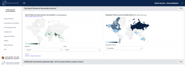
As a first step to providing openly accessible data and information on the anticipated widespread impacts on agricultural commodity supplies worldwide, the team has released a beta version of Harvest2Market. Originally planned for development over the course of 3 years, Harvest2Market was released in direct response to the immediate need for additional information on supply chain disruptions. It is an interactive online dashboard where analysts can explore the multi-faceted agrifood supply chain and glean insight on potential impacts of conflict disruptions to normal shipping routes, planted area, commodity stocks, and more.

Published on Wed, 03/23/2022 - 14:06

College of Behavorial & Social Sciences
  • Facebook
  • Twitter
  • Instagram
  • YouTube
  • LinkedIn
  • Zenfolio

Department of Geographical Sciences

2181 Samuel J. LeFrak Hall, 7251 Preinkert Drive,
University of Maryland, College Park, MD 20742
Phone: 301-405-4050

Join Our Newsletter

Contact Us

Links
  • UMD Land Acknowledgement
  • UMD Staff Directory
  • Give to GEOG
  • UMD Web Accessibility
  • Alumni
© 2025 College of Behavorial & Social Sciences. All Rights Reserved.
Login