UMD College of Behavorial & Social Sciences UMD College of Behavorial & Social Sciences
MENU

Topbar Menu

  • About Us
  • People
  • Alumni and Giving
  • Diversity
  • Undergraduate
    • Prospective Students
    • Courses & Facilities
    • Advising
    • Special Programs
    • Graduation
    • Geography Club
  • Graduate
    • Prospective Ph.D. Students
    • Graduate Courses
    • Graduate Student Publications
    • Graduate Student Awards
    • Graduate Students
    • Master of Science and Graduate Certificate Programs
    • Combined BS/MS Program
  • Research
    • Research Areas
      • Geospatial-Information Science and Remote Sensing
      • Human Dimensions of Global Change
      • Land Cover and Land Use Change
      • Carbon, Vegetation Dynamics and Landscape-Scale Processes
    • Centers
      • Center for Geospatial Information Science
      • International Center for Innovation in Geospatial Analytics & Earth Observation
  • High School Hub
    • Program Overview
    • High School Awards
    • High School Internship Program
    • GIS Day
  • Resources
    • Graduate Student Organization
    • Student Life
    • Graduate School
    • Responsible Conduct of Research
    • Emergency Preparedness
    • Job Opportunities
    • Graduation
Search

Main navigation

  • Undergraduate
    • Prospective Students
    • Courses & Facilities
    • Advising
    • Special Programs
    • Graduation
    • Geography Club
  • Graduate
    • Prospective Ph.D. Students
    • Graduate Courses
    • Graduate Student Publications
    • Graduate Student Awards
    • Graduate Students
    • Master of Science and Graduate Certificate Programs
    • Combined BS/MS Program
  • Research
    • Research Areas
      • Geospatial-Information Science and Remote Sensing
      • Human Dimensions of Global Change
      • Land Cover and Land Use Change
      • Carbon, Vegetation Dynamics and Landscape-Scale Processes
    • Centers
      • Center for Geospatial Information Science
      • International Center for Innovation in Geospatial Analytics & Earth Observation
  • High School Hub
    • Program Overview
    • High School Awards
    • High School Internship Program
    • GIS Day
  • Resources
    • Graduate Student Organization
    • Student Life
    • Graduate School
    • Responsible Conduct of Research
    • Emergency Preparedness
    • Job Opportunities
    • Graduation

Search our site:

Eyes on the Arctic

Breadcrumb

  • Home
  • Featured Content
  • Eyes On The Arctic
Sentinel-2

With Arctic sea ice fast approaching its minimum extent for the year, all eyes are once again on the region. The ice cover of the Arctic Ocean naturally waxes and wanes throughout the year, and by mid-September, it will reach its lowest areal extent. At the end of August 2020, the ice covered about 4.4 million km2 of the Arctic Ocean, down ~0.25 million km2 from this time last year. That’s a loss of ice area equivalent in size to about twice the Commonwealth of Virginia! The lowest ice extent in the 40-year satellite record was set in 2012, and this year we’re unlikely to see that record broken, due to the persistence of ice in the eastern Beaufort Sea this month. Nevertheless, the 2020 ice cover is still well below the climatological average.

Geographical Sciences Associate Professor, Dr. Sinead L. Farrell, is using data from NASA’s ICESat-2 satellite to monitor Arctic sea ice. Her findings were reported in a recent news article in Science magazine. Dr. Farrell and her team have discovered that ICESat-2 is capable of measuring the smallest features on the ice cover, including narrow pressure ridges and shallow melt ponds. Their analysis also shows that the older ice gets, the rougher it becomes. Meanwhile the German icebreaking research vessel, Polarstern, is frozen into the ice at the North Pole. On board, scientists from around the world are making measurements of the ice, ocean and atmosphere around the clock, as part of the “Multidisciplinary drifting Observatory for the Study of Arctic Climate” (MOSAiC) expedition. Together the field measurements and the satellite data from ICESat-2 will give us a better understanding of the health of the ice and its vulnerability to further decline. This information is needed to predict if the Arctic might become completely ice-free in summer sometime in the future. 

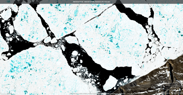
Image: Satellite image of azure blue melt ponds on sea ice floes in the Arctic Ocean, off the coast of northern Greenland in June 2020.


Image Credit: European Union, contains modified Copernicus Sentinel data 2020, processed with EO Browser

Published on Tue, 09/08/2020 - 06:53

College of Behavorial & Social Sciences
  • Facebook
  • Twitter
  • Instagram
  • YouTube
  • LinkedIn
  • Zenfolio

Department of Geographical Sciences

2181 Samuel J. LeFrak Hall, 7251 Preinkert Drive,
University of Maryland, College Park, MD 20742
Phone: 301-405-4050

Join Our Newsletter

Contact Us

Links
  • UMD Land Acknowledgement
  • UMD Staff Directory
  • Give to GEOG
  • UMD Web Accessibility
  • Alumni
© 2025 College of Behavorial & Social Sciences. All Rights Reserved.
Login