UMD College of Behavorial & Social Sciences UMD College of Behavorial & Social Sciences
MENU

Topbar Menu

  • About Us
  • People
  • Alumni and Giving
  • Diversity
  • Undergraduate
    • Prospective Students
    • Courses & Facilities
    • Advising
    • Special Programs
    • Graduation
    • Geography Club
  • Graduate
    • Prospective Ph.D. Students
    • Graduate Courses
    • Graduate Student Publications
    • Graduate Student Awards
    • Graduate Students
    • Master of Science and Graduate Certificate Programs
    • Combined BS/MS Program
  • Research
    • Research Areas
      • Geospatial-Information Science and Remote Sensing
      • Human Dimensions of Global Change
      • Land Cover and Land Use Change
      • Carbon, Vegetation Dynamics and Landscape-Scale Processes
    • Centers
      • Center for Geospatial Information Science
      • International Center for Innovation in Geospatial Analytics & Earth Observation
  • High School Hub
    • Program Overview
    • High School Awards
    • High School Internship Program
    • GIS Day
  • Resources
    • Graduate Student Organization
    • Student Life
    • Graduate School
    • Responsible Conduct of Research
    • Emergency Preparedness
    • Job Opportunities
    • Graduation
Search

Main navigation

  • Undergraduate
    • Prospective Students
    • Courses & Facilities
    • Advising
    • Special Programs
    • Graduation
    • Geography Club
  • Graduate
    • Prospective Ph.D. Students
    • Graduate Courses
    • Graduate Student Publications
    • Graduate Student Awards
    • Graduate Students
    • Master of Science and Graduate Certificate Programs
    • Combined BS/MS Program
  • Research
    • Research Areas
      • Geospatial-Information Science and Remote Sensing
      • Human Dimensions of Global Change
      • Land Cover and Land Use Change
      • Carbon, Vegetation Dynamics and Landscape-Scale Processes
    • Centers
      • Center for Geospatial Information Science
      • International Center for Innovation in Geospatial Analytics & Earth Observation
  • High School Hub
    • Program Overview
    • High School Awards
    • High School Internship Program
    • GIS Day
  • Resources
    • Graduate Student Organization
    • Student Life
    • Graduate School
    • Responsible Conduct of Research
    • Emergency Preparedness
    • Job Opportunities
    • Graduation
  • About Us
  • People
  • Alumni and History
  • Diversity

Search our site:

Esri and UMD Honor Top Talent with 2024 Geographical Sciences Scholarships

Breadcrumb

  • Home
  • Featured Content
  • Esri and UMD Honor Top Talent With 2024 Geographical Sciences Scholarships
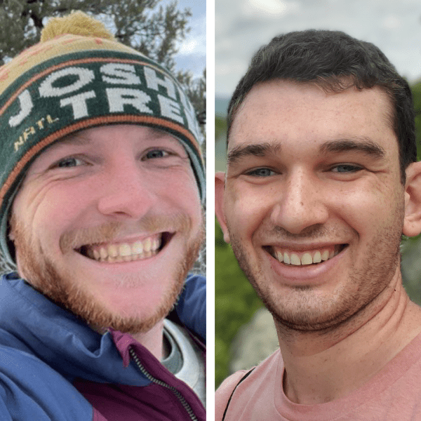
headshot of Esri scholarship winners

We are thrilled to announce the winners of the 2024 Geographical Sciences MS Qualified Tuition Scholarships!

This prestigious scholarship is a result of a collaboration between Esri and our Master of Science program. It is awarded to one exceptional Esri employee admitted to the MS GIS and MS GEOINT programs. Both the Department of Geographical Sciences and Esri each sponsor a student.

Charlie Lott headshotEsri-Sponsored Recipient - Charlie Lott (MS GIS)

Charlie Lott works in Esri’s Digital Experience Marketing Department, where he combines ArcGIS Pro with content creation software like Adobe Creative Cloud, Maxon Cinema 4D and Blender to produce animated maps for Esri’s website, marketing materials and Maps.com.

Why pursue an MS in GIS at UMD?

“I’m interested in obtaining my MS GIS at UMD because I want to improve my technical cartographic and GIS skills to better uncover and communicate patterns in data, making it more understandable, interactive and visually compelling.”


Thomas Brynn headshotGEOG-Sponsored Recipient - Thomas Bryn (MS GEOINT)

Thomas Bryn is a solution engineer with Esri, supporting users within the U.S. Federal Government and Geospatial Intelligence community. He has extensive experience in applied analysis within the National Government domain and holds a B.S. from James Madison University in Intelligence Analysis, with concentrations in Geospatial Intelligence, Geographic Science, and Interdisciplinary Studies. Thomas specializes in integrating spatial analysis, intelligence analysis, graph analysis and text analysis. He is a subject matter expert (SME) in ArcGIS Knowledge, helping staff and users learn advanced analysis of relationships and connections within data.

Why pursue an MS in GEOINT at UMD?

“I was most attracted to this program for the opportunity to dive deeper into applications of geospatial technology in the context of intelligence to support my passion for helping users advance the analysis discipline.”

Images courtesy of Lott and Bryn

Published on Mon, 08/05/2024 - 15:40

College of Behavorial & Social Sciences
  • Facebook
  • Twitter
  • Instagram
  • YouTube
  • LinkedIn
  • Zenfolio

Department of Geographical Sciences

2181 Samuel J. LeFrak Hall, 7251 Preinkert Drive,
University of Maryland, College Park, MD 20742
Phone: 301-405-4050

Join Our Newsletter

Contact Us

Links
  • UMD Land Acknowledgement
  • UMD Staff Directory
  • Give to GEOG
  • UMD Web Accessibility
  • Alumni
© 2025 College of Behavorial & Social Sciences. All Rights Reserved.
Login