UMD College of Behavorial & Social Sciences UMD College of Behavorial & Social Sciences
MENU

Topbar Menu

  • About Us
  • People
  • Alumni and Giving
  • Diversity
  • Undergraduate
    • Prospective Students
    • Courses & Facilities
    • Advising
    • Special Programs
    • Graduation
    • Geography Club
  • Graduate
    • Prospective Ph.D. Students
    • Graduate Courses
    • Graduate Student Publications
    • Graduate Student Awards
    • Graduate Students
    • Master of Science and Graduate Certificate Programs
    • Combined BS/MS Program
  • Research
    • Research Areas
      • Geospatial-Information Science and Remote Sensing
      • Human Dimensions of Global Change
      • Land Cover and Land Use Change
      • Carbon, Vegetation Dynamics and Landscape-Scale Processes
    • Centers
      • Center for Geospatial Information Science
      • International Center for Innovation in Geospatial Analytics & Earth Observation
  • High School Hub
    • Program Overview
    • High School Awards
    • High School Internship Program
    • GIS Day
  • Resources
    • Graduate Student Organization
    • Student Life
    • Graduate School
    • Responsible Conduct of Research
    • Emergency Preparedness
    • Job Opportunities
    • Graduation
Search

Main navigation

  • Undergraduate
    • Prospective Students
    • Courses & Facilities
    • Advising
    • Special Programs
    • Graduation
    • Geography Club
  • Graduate
    • Prospective Ph.D. Students
    • Graduate Courses
    • Graduate Student Publications
    • Graduate Student Awards
    • Graduate Students
    • Master of Science and Graduate Certificate Programs
    • Combined BS/MS Program
  • Research
    • Research Areas
      • Geospatial-Information Science and Remote Sensing
      • Human Dimensions of Global Change
      • Land Cover and Land Use Change
      • Carbon, Vegetation Dynamics and Landscape-Scale Processes
    • Centers
      • Center for Geospatial Information Science
      • International Center for Innovation in Geospatial Analytics & Earth Observation
  • High School Hub
    • Program Overview
    • High School Awards
    • High School Internship Program
    • GIS Day
  • Resources
    • Graduate Student Organization
    • Student Life
    • Graduate School
    • Responsible Conduct of Research
    • Emergency Preparedness
    • Job Opportunities
    • Graduation
  • About Us
  • People
  • Alumni and History
  • Diversity

Search our site:

Enroll Now: Summer Graduate Courses in GIS and Geospatial Intelligence

Breadcrumb

  • Home
  • Featured Content
  • Enroll Now: Summer Graduate Courses In GIS and Geospatial Intelligence
List of Geographical Sciences Summer 2025 Courses

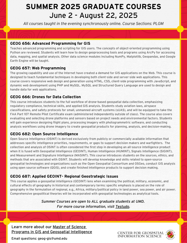
The Department of Geographical Sciences is offering a range of graduate-level courses this summer. All courses are open to graduate students across the university and are taught synchronously online in the evening. 

Here are the courses for Summer 2025:

GEOG 656: Advanced Programming for GIS

Covers advanced programming and scripting for GIS using Python. Topics include object-oriented programming, designing geoprocessing tools with ArcPy, and working with data science modules such as NumPy, Matplotlib, Geopandas, and Google Earth Engine.

GEOG 657: Web Programming

Introduces the development of web-based GIS applications. Students will learn responsive web design using HTML and CSS, client-side programming with JavaScript, and server-side development using PHP and MySQL.

GEOG 666: Drones for Data Collection

Covers the complete workflow for drone-based data collection, from aviation laws and safety protocols to flight planning, imagery processing, and GIS analysis. Prepares students for the FAA Part 107 Remote Pilot Certificate exam (exam taken independently).

GEOG 682: Open Source Intelligence

Focuses on collecting and analyzing publicly available data to support intelligence and decision-making. Includes training in open-source geospatial tools such as QGIS, and introduces key concepts related to OSINT ethics, methods, and applications.

GEOG 687: Applied GEOINT – Regional Geostrategic Issues

Explores how geography influences political, military, economic, and cultural dynamics in different regions. The course combines geopolitical theory with geospatial analysis.

The deadline to enroll is June 2. Please select course section PLGM.

Details and Enroll via Testudo


Published on Tue, 05/27/2025 - 11:23

College of Behavorial & Social Sciences
  • Facebook
  • Twitter
  • Instagram
  • YouTube
  • LinkedIn
  • Zenfolio

Department of Geographical Sciences

2181 Samuel J. LeFrak Hall, 7251 Preinkert Drive,
University of Maryland, College Park, MD 20742
Phone: 301-405-4050

Join Our Newsletter

Contact Us

Links
  • UMD Land Acknowledgement
  • UMD Staff Directory
  • Give to GEOG
  • UMD Web Accessibility
  • Alumni
© 2025 College of Behavorial & Social Sciences. All Rights Reserved.
Login