UMD College of Behavorial & Social Sciences UMD College of Behavorial & Social Sciences
MENU

Topbar Menu

  • About Us
  • People
  • Alumni and Giving
  • Diversity
  • Undergraduate
    • Prospective Students
    • Courses & Facilities
    • Advising
    • Special Programs
    • Graduation
    • Geography Club
  • Graduate
    • Prospective Ph.D. Students
    • Graduate Courses
    • Graduate Student Publications
    • Graduate Student Awards
    • Graduate Students
    • Master of Science and Graduate Certificate Programs
    • Combined BS/MS Program
  • Research
    • Research Areas
      • Geospatial-Information Science and Remote Sensing
      • Human Dimensions of Global Change
      • Land Cover and Land Use Change
      • Carbon, Vegetation Dynamics and Landscape-Scale Processes
    • Centers
      • Center for Geospatial Information Science
      • International Center for Innovation in Geospatial Analytics & Earth Observation
  • High School Hub
    • Program Overview
    • High School Awards
    • High School Internship Program
    • GIS Day
  • Resources
    • Graduate Student Organization
    • Student Life
    • Graduate School
    • Responsible Conduct of Research
    • Emergency Preparedness
    • Job Opportunities
    • Graduation
Search

Main navigation

  • Undergraduate
    • Prospective Students
    • Courses & Facilities
    • Advising
    • Special Programs
    • Graduation
    • Geography Club
  • Graduate
    • Prospective Ph.D. Students
    • Graduate Courses
    • Graduate Student Publications
    • Graduate Student Awards
    • Graduate Students
    • Master of Science and Graduate Certificate Programs
    • Combined BS/MS Program
  • Research
    • Research Areas
      • Geospatial-Information Science and Remote Sensing
      • Human Dimensions of Global Change
      • Land Cover and Land Use Change
      • Carbon, Vegetation Dynamics and Landscape-Scale Processes
    • Centers
      • Center for Geospatial Information Science
      • International Center for Innovation in Geospatial Analytics & Earth Observation
  • High School Hub
    • Program Overview
    • High School Awards
    • High School Internship Program
    • GIS Day
  • Resources
    • Graduate Student Organization
    • Student Life
    • Graduate School
    • Responsible Conduct of Research
    • Emergency Preparedness
    • Job Opportunities
    • Graduation
  • About Us
  • People
  • Alumni and History
  • Diversity

Search our site:

Dr. Chengquan Huang Quoted by New York Times Article, Emphasizing Importance of Spy Satellite Data for Better Prediction of Future Changes

Breadcrumb

  • Home
  • Featured Content
  • Dr. Chengquan Huang Quoted By New York Times Article, Emphasizing Importance of Spy Satellite Data For Better Prediction of Future Changes
Figure shows 4 Landsat images comparing

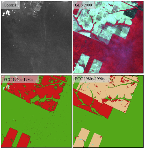
Forest change records derived using modern satellites (e.g., Landsat) can only go back to the 1980s (at 30 m resolution) or 1970s (at 60 m resolution). However, large changes might have occurred in the previous decades in many regions of the world. Back in 2015, Geographical Sciences student Danxia Song (supervised by Drs. John Townshend and Chengquan Huang) published one of the earliest studies demonstrating the usefulness of declassified spy satellite data for extending forest change records from modern satellite data back to the 1960s. Due to technological limitations at that time, the spy satellite data lacked the high geometric and radiometric qualities of modern data; hence it is still not widely used in land change studies. A recent New York Times article provided a review of the spy satellite program and highlighted some of the uses of the collected data in recent studies. In that article, Dr. Huang pointed out the importance of a longer record from the declassified satellite data for studying future changes.

The New York Times article is available from https://www.nytimes.com/2021/01/05/science/corona-satellites-environment.html. Below is a citation to the paper published by Danxia Song:

Song, D.-X., Huang, C., Sexton, J.O., Channan, S., Feng, M., & Townshend, J.R. (2015). Use of Landsat and Corona data for mapping forest cover change from the mid-1960s to 2000s: Case studies from the Eastern United States and Central Brazil. ISPRS Journal of Photogrammetry and Remote Sensing, 103, 81-92.

Published on Mon, 01/25/2021 - 12:08

College of Behavorial & Social Sciences
  • Facebook
  • Twitter
  • Instagram
  • YouTube
  • LinkedIn
  • Zenfolio

Department of Geographical Sciences

2181 Samuel J. LeFrak Hall, 7251 Preinkert Drive,
University of Maryland, College Park, MD 20742
Phone: 301-405-4050

Join Our Newsletter

Contact Us

Links
  • UMD Land Acknowledgement
  • UMD Staff Directory
  • Give to GEOG
  • UMD Web Accessibility
  • Alumni
© 2025 College of Behavorial & Social Sciences. All Rights Reserved.
Login