UMD College of Behavorial & Social Sciences UMD College of Behavorial & Social Sciences
MENU

Topbar Menu

  • About Us
  • People
  • Alumni and Giving
  • Diversity
  • Undergraduate
    • Prospective Students
    • Courses & Facilities
    • Advising
    • Special Programs
    • Graduation
    • Geography Club
  • Graduate
    • Prospective Ph.D. Students
    • Graduate Courses
    • Graduate Student Publications
    • Graduate Student Awards
    • Graduate Students
    • Master of Science and Graduate Certificate Programs
    • Combined BS/MS Program
  • Research
    • Research Areas
      • Geospatial-Information Science and Remote Sensing
      • Human Dimensions of Global Change
      • Land Cover and Land Use Change
      • Carbon, Vegetation Dynamics and Landscape-Scale Processes
    • Centers
      • Center for Geospatial Information Science
      • International Center for Innovation in Geospatial Analytics & Earth Observation
  • High School Hub
    • Program Overview
    • High School Awards
    • High School Internship Program
    • GIS Day
  • Resources
    • Graduate Student Organization
    • Student Life
    • Graduate School
    • Responsible Conduct of Research
    • Emergency Preparedness
    • Job Opportunities
    • Graduation
Search

Main navigation

  • Undergraduate
    • Prospective Students
    • Courses & Facilities
    • Advising
    • Special Programs
    • Graduation
    • Geography Club
  • Graduate
    • Prospective Ph.D. Students
    • Graduate Courses
    • Graduate Student Publications
    • Graduate Student Awards
    • Graduate Students
    • Master of Science and Graduate Certificate Programs
    • Combined BS/MS Program
  • Research
    • Research Areas
      • Geospatial-Information Science and Remote Sensing
      • Human Dimensions of Global Change
      • Land Cover and Land Use Change
      • Carbon, Vegetation Dynamics and Landscape-Scale Processes
    • Centers
      • Center for Geospatial Information Science
      • International Center for Innovation in Geospatial Analytics & Earth Observation
  • High School Hub
    • Program Overview
    • High School Awards
    • High School Internship Program
    • GIS Day
  • Resources
    • Graduate Student Organization
    • Student Life
    • Graduate School
    • Responsible Conduct of Research
    • Emergency Preparedness
    • Job Opportunities
    • Graduation
  • About Us
  • People
  • Alumni and History
  • Diversity

Search our site:

Disturbance Distance: Researchers Employ a New Framework to Measure Forest Vulnerability to Increases in Disturbance Rates in New ERL Study

Breadcrumb

  • Home
  • Featured Content
  • Disturbance Distance: Researchers Employ a New Framework To Measure Forest Vulnerability To Increases In Disturbance Rates In New ERL Study
Geographic variation in estimated threshold disturbance rates

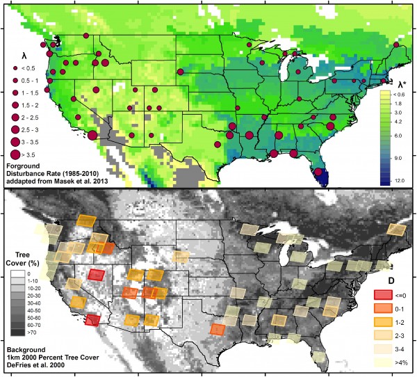
In a recent paper published in Environmental Research Letters (ERL), a team of researchers led by Department of Geographical science’s Post-doc Katelyn Dolan introduce a new framework to assess forest vulnerability to increased disturbance rates.  By comparing modeled estimates of ecosystem growth under various disturbance rates with annual satellite observations of forest disturbances, researchers estimated the increases in observed disturbance rates that may push forested ecosystems across the US into non-forest states, terming the metric of vulnerability a sites ‘Disturbance Distance’.   

The abstract of the article follows:

“Disturbances, both natural and anthropogenic, are critical determinants of forest structure, function, and distribution. The vulnerability of forests to potential changes in disturbance rates remains largely unknown. Here, we developed a framework for quantifying and mapping the vulnerability of forests to changes in disturbance rates. By comparing recent estimates of observed forest disturbance rates over a sample of contiguous US forests to modeled rates of disturbance resulting in forest loss, a novel index of vulnerability, Disturbance Distance, was produced. Sample results indicate that 20% of current US forestland could be lost if disturbance rates were to double, with southwestern forests showing highest vulnerability. Under a future climate scenario, the majority of US forests showed capabilities of withstanding higher rates of disturbance then under the current climate scenario, which may buffer some impacts of intensified forest disturbance.”


Members of the research team include:

Katelyn A Dolan 1, George C Hurtt 1, Steve A Flanagan 1, Justin P Fisk 1,2, Ritvik Sahajpal 1, Chengquan Huang1, Yannik Le Page1,3, Ralph Dubayah 1, and Jeffrey G Masek 4

1. Department of Geographical Sciences, University of Maryland, College Park, MD 2. Applied Geosolutions, 87 Packers Falls Road, Durham, NH 3.Centro de Estudos Florestais, Instituto Superior de Agronomia, Universidade de Lisboa, Tapada da Ajuda, 1349-017 Lisbon, Portugal  4. Biospheric Sciences Laboratory NASA Goddard Space Flight Center, Greenbelt MD

Published on Thu, 11/02/2017 - 15:20

College of Behavorial & Social Sciences
  • Facebook
  • Twitter
  • Instagram
  • YouTube
  • LinkedIn
  • Zenfolio

Department of Geographical Sciences

2181 Samuel J. LeFrak Hall, 7251 Preinkert Drive,
University of Maryland, College Park, MD 20742
Phone: 301-405-4050

Join Our Newsletter

Contact Us

Links
  • UMD Land Acknowledgement
  • UMD Staff Directory
  • Give to GEOG
  • UMD Web Accessibility
  • Alumni
© 2025 College of Behavorial & Social Sciences. All Rights Reserved.
Login