
Cold Coverage: Scientist Examines Sea Ice Via Satellite, Plane and Snowmobile
THE BEST SNACK TO BRING on an Arctic mission, Associate Professor Sinead Farrell declares, is chocolate. A banana or sandwich will be as chewable as a backyard paver after a few miles on a snowmobile. That bar, however, will melt right in your mouth, even if it’s 5 degrees Fahrenheit outside.
That’s the kind of surprising tidbit Farrell has learned over nearly a dozen trips to the North and South poles for research on sea ice. A faculty member in the departments of Geographical Sciences and Atmospheric and Oceanic Science, she has used remote sensing to determine long-term changes and year-over-year fluctuations in ice cover for nearly two decades. To validate satellite data, her team takes measurements from aircraft and on the ground.

In December, she authored part of the annual Arctic Report Card, which found that sea ice cover in March 2025 was the smallest winter maximum recorded in 47 years, 8% lower than the long-term average.
She explains why sea ice is so important, how she once saw five sunsets in one day and why she only uses mechanical pencils in the field.
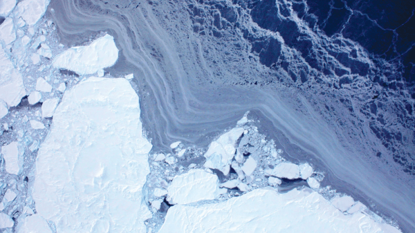
Why does the Earth need sea ice?
It regulates the global temperature and helps keep the planet cool, which is what we all need to survive. If less of the Arctic Ocean is insulated with ice, this allows more heat from the sun to be absorbed by the ocean each summer, which melts more sea ice, exposing more of the ocean and so on.
It’s also important for biodiversity. The marine food web depends on it, everything from birds to seals to orca. People also use it for transportation between villages and hunting.
Why do we need to know how it fluctuates?
Many livelihoods depend on knowledge of conditions. Summer is the busiest time in the Arctic for tourists, wildlife and industry. For example, the Bering Sea is the crab and lobster fishery capital of the world, and the shipping trade in the polar regions is growing rapidly.
How do you survey by plane?
The majority of my field research has been on NASA aircraft, over places like Greenland and Alaska. I’ve also flown from southern Chile over Antarctica and back. We use lots of instruments to take infrared, visible and radar measurements to get a much more complete picture of the total thickness of the snow and ice. From a satellite image, taken from 600 kilometers away (roughly the distance from D.C. to Boston), there’s no context: Is this long ice ridge 1 foot tall? Five feet tall? We’re using new techniques to measure the ice from space to get a handle on the volume of ice not just the area; if you lose area but thicken the ice so it’s more dense, that could be harder to melt. But if there’s less area and it’s thinner, it will melt quicker.
Over the 14-hour flight, we crossed multiple time zones, so the sun set again and again as we crossed time zones. It was really fascinating!
Read the Full Interview in TERP Magazine
Published on Fri, 02/06/2026 - 12:20