UMD College of Behavorial & Social Sciences UMD College of Behavorial & Social Sciences
MENU

Topbar Menu

  • About Us
  • People
  • Alumni and Giving
  • Diversity
  • Undergraduate
    • Prospective Students
    • Courses & Facilities
    • Advising
    • Special Programs
    • Graduation
    • Geography Club
  • Graduate
    • Prospective Ph.D. Students
    • Graduate Courses
    • Graduate Student Publications
    • Graduate Student Awards
    • Graduate Students
    • Master of Science and Graduate Certificate Programs
    • Combined BS/MS Program
  • Research
    • Research Areas
      • Geospatial-Information Science and Remote Sensing
      • Human Dimensions of Global Change
      • Land Cover and Land Use Change
      • Carbon, Vegetation Dynamics and Landscape-Scale Processes
    • Centers
      • Center for Geospatial Information Science
      • International Center for Innovation in Geospatial Analytics & Earth Observation
  • High School Hub
    • Program Overview
    • High School Awards
    • High School Internship Program
    • GIS Day
  • Resources
    • Graduate Student Organization
    • Student Life
    • Graduate School
    • Responsible Conduct of Research
    • Emergency Preparedness
    • Job Opportunities
    • Graduation
Search

Main navigation

  • Undergraduate
    • Prospective Students
    • Courses & Facilities
    • Advising
    • Special Programs
    • Graduation
    • Geography Club
  • Graduate
    • Prospective Ph.D. Students
    • Graduate Courses
    • Graduate Student Publications
    • Graduate Student Awards
    • Graduate Students
    • Master of Science and Graduate Certificate Programs
    • Combined BS/MS Program
  • Research
    • Research Areas
      • Geospatial-Information Science and Remote Sensing
      • Human Dimensions of Global Change
      • Land Cover and Land Use Change
      • Carbon, Vegetation Dynamics and Landscape-Scale Processes
    • Centers
      • Center for Geospatial Information Science
      • International Center for Innovation in Geospatial Analytics & Earth Observation
  • High School Hub
    • Program Overview
    • High School Awards
    • High School Internship Program
    • GIS Day
  • Resources
    • Graduate Student Organization
    • Student Life
    • Graduate School
    • Responsible Conduct of Research
    • Emergency Preparedness
    • Job Opportunities
    • Graduation
  • About Us
  • People
  • Alumni and History
  • Diversity

Search our site:

The Best Places to Plant Trees in Maryland

Breadcrumb

  • Home
  • Featured Content
  • The Best Places To Plant Trees In Maryland
Maryland maps

Nature has provided an effective tool for removing some climate-warming carbon from the atmosphere—trees. Through photosynthesis, trees pull carbon dioxide out of the air and can store it for hundreds of years. But knowing the best places to plant them—to get the most environmental and economic benefits—can be a challenge.

Using high-resolution lidar data, satellite imagery, and modeling, a team of researchers supported by the NASA Carbon Monitoring System (CMS) has developed a method to help the state of Maryland assess the best places to grow trees. The method considers both the carbon storage potential and economic opportunity of the land.

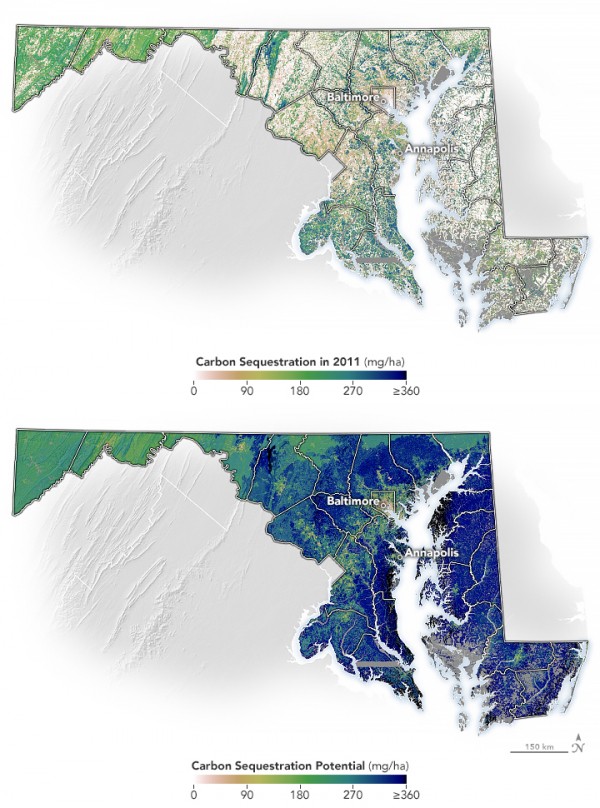
First, the researchers mapped how much carbon could be captured (or sequestered) by trees and other plants based on local environmental conditions. The map above (top) shows the amount of carbon stored in trees and other vegetation (also known as above-ground biomass) across Maryland as of 2011. The other map (bottom) shows the amount of carbon that could potentially be stored in vegetation, based on climate, soil type, and land use across the state. For example, Eastern Maryland has a warmer and longer growing season than western parts of the state, allowing for more tree growth and more carbon storage.

Statewide, there is potential to soak up nearly three times as much carbon in vegetation compared to what was sequestered in 2011. The data behind the map rely on Landsat satellite imagery and high-resolution airborne lidar measurements of tree height and canopy extent.

Read the full article by Emily Cassidy on NASA's Earth Observatory

Images by Michala Garrison, based on data from Hurtt et al. (2019).

Contributions to this research came from members of the Department of Geographical Sciences at the University of Maryland, including Professor and Associate Chair George Hurtt, Alum and Adunct Assistant Professor Rachel Lamb, and Alum  Marie Panday, Assistant Research Professor Lei Ma, Professor Ralph Dubayah and Associate Research Professor Ritvik Sahajpal, in addition to M. Zhao, A. Armstrong, R. Birdsey, E. Campbell, K. Dolan,  J.P. Fisk, S. Flanagan, C. Huang, W. Huang, K. Johnson, R. Marks, D. O'Leary III, J. O'Neil-Dunne, A. Swatantran and H. Tang; also noting NASA contributions of the NASA Carbon Monitoring System.

Published on Thu, 09/07/2023 - 11:33

College of Behavorial & Social Sciences
  • Facebook
  • Twitter
  • Instagram
  • YouTube
  • LinkedIn
  • Zenfolio

Department of Geographical Sciences

2181 Samuel J. LeFrak Hall, 7251 Preinkert Drive,
University of Maryland, College Park, MD 20742
Phone: 301-405-4050

Join Our Newsletter

Contact Us

Links
  • UMD Land Acknowledgement
  • UMD Staff Directory
  • Give to GEOG
  • UMD Web Accessibility
  • Alumni
© 2025 College of Behavorial & Social Sciences. All Rights Reserved.
Login